
Heavy Rain, Flooding, and Chance of Severe Weather Staring Down the Southern U.S.
January 22, 2024
Posted: March 13, 2023 3:54 pm


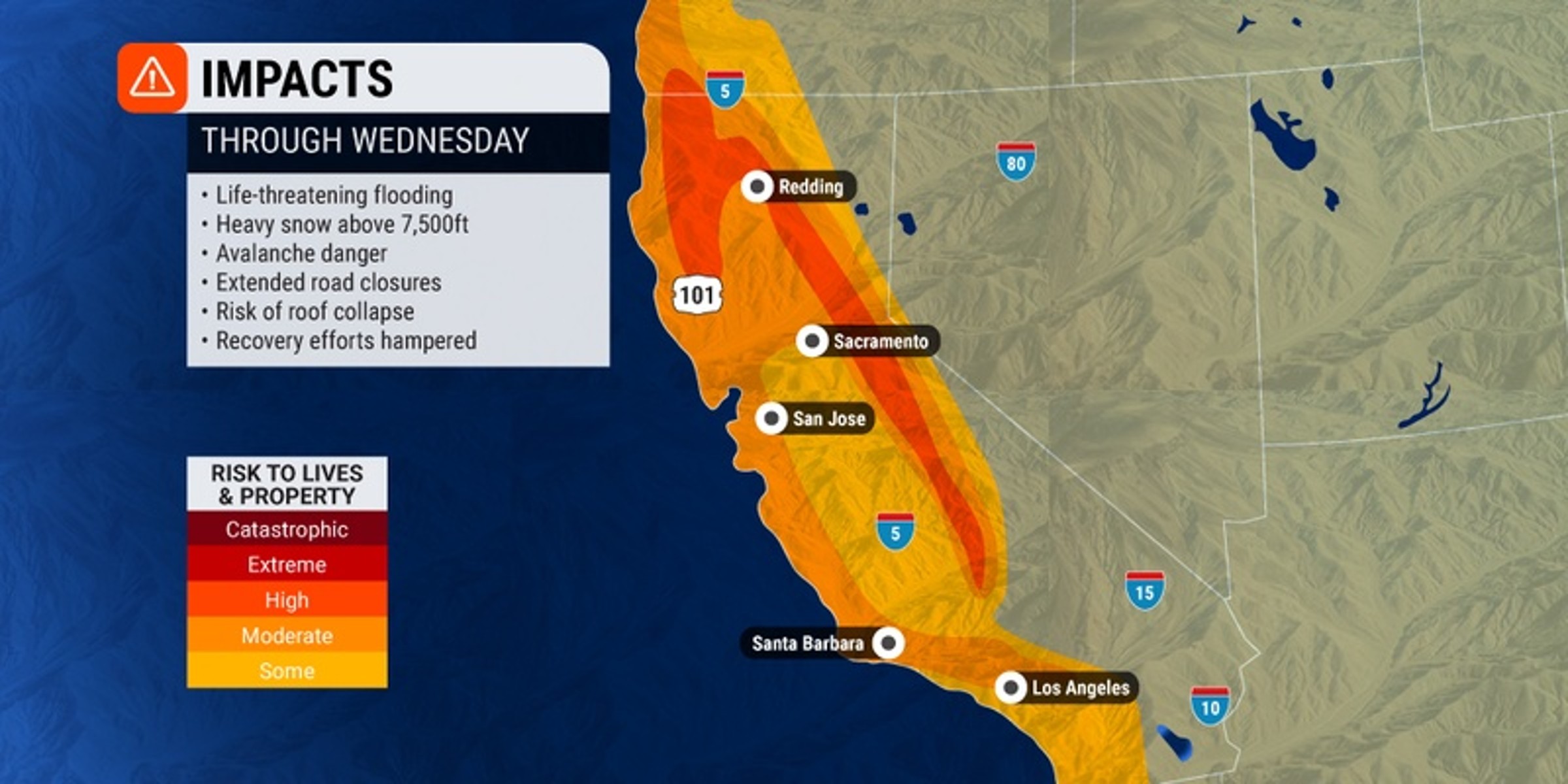
After periods of slightly drier weather, another atmospheric river is forecast to set up across California to start the week. This firehose of moisture will bring another round of torrential rain to the lower elevations and heavy snow to the higher terrain in the coming days.
It will be a rocky start to the week when more energy moves into the Golden State and creates multiple rounds of snow throughout the Sierra Nevada, the Klamath Mountains, and the southern Cascade Range. The most significant accumulation will occur over 6,000 feet with snowfall measured in feet possible at these elevations.
This amount of snow will undoubtedly trigger the risk of avalanches and disrupt travel with road closures. The snow will also be enough to raise the chances of roof collapses and other structural damage to buildings as a result of the heavy snow.
The snow will pair with gusty southerly winds that whip up to 45 mph across some parts of Northern California on Monday. Reduced visibility will be an issue as these winds meet up with the snow.
In addition to the snow, rain showers will continue to pound the northern and central parts of the state in the lower elevations. Flooding may be an issue late Monday and into Tuesday in the San Francisco area. Although Monday afternoon may see some breaks in the precipitation, residents should not let their guard down.
Rainfall totals will hover around 2 inches in San Francisco on Monday night through Tuesday. The rain will finally begin to let up in the Bay Area late Tuesday after the sun goes down.
Areas in California that have already seen significant amounts of rain over the last week will be at the greatest risk of flooding and road washouts. This is because these locations will be dealing with a low water threshold because of the already saturated ground from the previous rounds of storms.
The first three days of the work week are forecast to bring widespread rain totals of 2 – 4 inches in a zone north of San Francisco stretching from the town of Santa Rosa through Redding. This heavy rain will extend as far north as coastal southwest Oregon. The greatest amount of rain is likely to fall in the western facing slopes of the Klamath Mountains and the Sierra Nevada at the lower elevations.
As far as timing, the bulk of the rain will fall late Monday and through Tuesday. This is when the center of the storm will move onshore from the Pacific Ocean.
Forecasters expect snow levels to rise throughout the day Monday to about 8,000 feet as warmer temperatures come in with the storm. Also worrisome is the fact that the mid-elevation snow from the past week will be in danger of melting rapidly as the mercury climbs. This could result in a major flooding threat as the snow turns to water quickly.
Once again, the Sierra Nevada will see the highest amount of accumulation. However, snow will be limited to elevations of 8,000 feet or greater. The worst of the snow for this region is forecast to start flying Tuesday morning and let up by the overnight hours.
This is the state’s tenth atmospheric river that it has seen this winter season. At least two fatalities have been blamed on the latest event. U.S. President Joe Biden approved a request for an emergency declaration for the state as storms continue to ravage the West Coast.
When will the state finally get a break from this weather? Dry conditions are in the forecast by the middle of the week. Some parts of northern and central California will even see some sunshine by Thursday as the moisture and clouds move out of the region.
This dry weather will hang on through late week and into the weekend for California. The next weather maker is set to take aim at Oregon and Washington by late Thursday and into Friday. This will bring an active weather pattern for cities such as Portland and Seattle heading into the weekend.
Did you find this content useful? Feel free to bookmark or to post to your timeline for reference later.

January 21, 2024

January 19, 2024

January 18, 2024
