
Heavy Rain, Flooding, and Chance of Severe Weather Staring Down the Southern U.S.
January 22, 2024
Posted: February 7, 2023 4:12 pm


Central U.S. Forecast to See Snow Late Wednesday Into Thursday
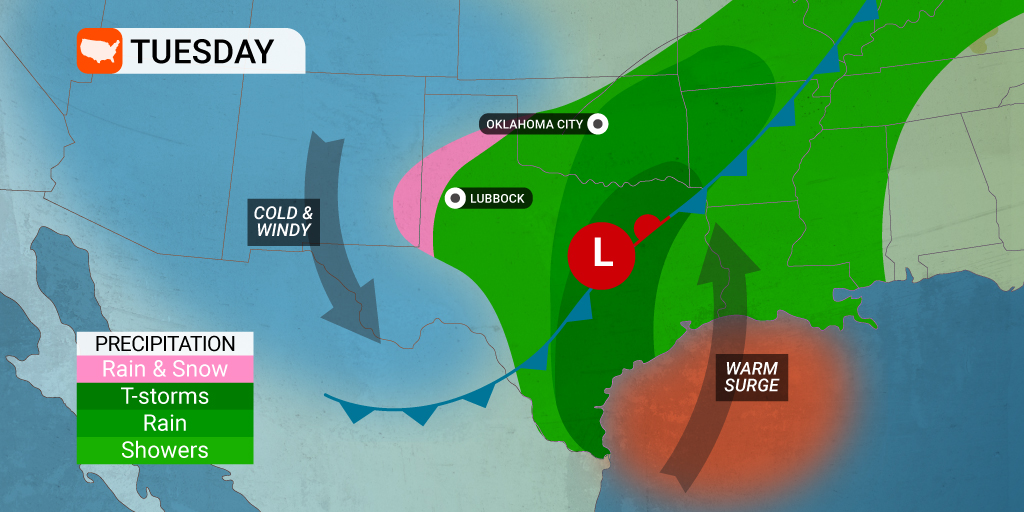
A dynamic storm system swinging down from the Rockies into the Mississippi Valley will bring a number of severe weather impacts to the south-central U.S. on Wednesday. This system will come with the possibility of tornadoes along with the more typical severe weather offerings. Meanwhile, the northern edge of the system will produce snow for those in its path. Here is what you need to be aware of if you live in the potential impact zone.
The severe weather risks will increase as the jet stream pushes to the south into the lower Mississippi Valley. This movement will usher in strong southerly winds that have the strength to bring up moisture from the Gulf of Mexico. This moisture will serve as the backbone for thunderstorm development during the afternoon and evening on Wednesday.
According to the National Weather Service (NWS) Storm Prediction Center (SPC), over 26 million Americans will be in the potential impact area of severe weather on Wednesday. The biggest risks for severe weather will spread across Louisiana, Mississippi, and southeastern Arkansas. Travelers using interstates 10, 20, 40, and 55 will want to be aware of any developing storm cells.
Severe thunderstorms will possibly hamper the afternoon commutes for people in cities such as Little Rock, Memphis, and Shreveport. Isolated tornadoes are also a threat for cities such as New Orleans and Jackson. The peak of the severe weather will happen in the late afternoon through evening hours with the greatest risk of twisters coming on the early end of that time frame.
As is typical for tornadic activity, the most likely area of development will be ahead of the strongest storm cells. This is because these storm cells boast the strongest area of rotation that is able to pull in the warm and moist air to fuel the tornadoes.
The risk of tornadoes will dwindle after the sun goes down, however, this is the time of the day that the winds are expected to increase. Forecasters are also warning that you cannot rule out an isolated tornado that spins up under the cover of darkness. It is also possible that tornadic activity may be hidden by the heavy rain in the area. This makes it important to enable all smartphone alerts.
This part of the country has seen its fair share of tornadoes already this year. Water temperatures in the Gulf of Mexico have been registering about 5 – 10 degrees above normal, serving as the impetus for a large number of severe weather outbreaks. These outbreaks have produced tornadoes as far north as the Great Lakes.
The jet stream energy is not forecast to stick around past Thursday. This means that this rash of severe weather will likely be confined to the Gulf Coast and south-central U.S., sparing those locations to the north and the east.
In addition to the thunderstorms and isolated tornadoes, this weather maker will also deliver a soaking rain to the region. You can expect a general 1 – 3 inches of rain to fall in an area stretching from the northwestern and central Gulf Coast area up into the lower Ohio Valley and the mid-Mississippi Valley.
This heavy rain may trigger flooding across small streams and in urban areas without proper drainage. Although the rain is good news for the Mississippi River as it tries to replenish its water levels, some of the region’s secondary rivers are already hovering at minor flood levels. In addition, Mississippi’s Pearl River and Big Black River are already at moderate flood stage heading into the spring.
The north side of this storm system will produce snow for a large part of the central U.S. Colder temperatures in place will turn any moisture associated with the large system to fall as snow rather than rain. Accumulating snow will be the story of the day Wednesday and Thursday in an area of northeastern Kansas moving up into northern Michigan.
This impact area includes long stretches of interstates 35, 80, 90, and 94 across Iowa, Wisconsin, and Missouri. Snowfall will total a few inches in most areas with up to a foot of new accumulation in central Wisconsin. Cities that are likely to pick up at least a few inches include Des Moines and Green Bay starting late Wednesday and continuing through Thursday.
Areas that will likely dodge the flakes are Omaha, Kansas City, Chicago, and Milwaukee. However, a slight shift in the front could bring a few isolated flurries to these areas.
Did you find this content useful? Feel free to bookmark or to post to your timeline for reference later.

January 21, 2024

January 19, 2024

January 18, 2024
