Heavy Rain, Flooding, and Chance of Severe Weather Staring Down the Southern U.S.
January 22, 2024
Posted: May 10, 2022 2:46 pm


The recent dreary weather that has been plaguing the Northeast over the last few weeks is coming to an end thanks to a ridge of high pressure that is setting up over this corner of the U.S.
This high pressure will usher in a warmer and drier pattern to both the Northeast and the mid-Atlantic throughout the week. This pattern will be a sharp contrast to the consistent precipitation, gray skies, and cooler temperatures that have characterized May so far.
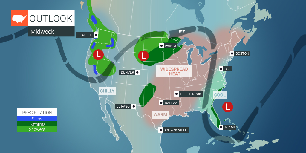
Many areas of Pennsylvania, Maryland, Virginia, and West Virginia recorded heavy rain over the weekend. At least one fatality was attributed to rising flood waters in West Virginia. The jet stream is retreating to the north now that this storm has moved offshore. This northward bulge in the jet stream will provide the necessary atmospheric conditions for the bulk of the region to enjoy a string of dry days as the storm track shifts up.
The record-breaking heat that is now in the southern Plains and the Midwest will continue its jaunt to the north and east, bringing this warmth to the eastern tier of the nation. The heat will migrate into New England this week with high temperature readings climbing into the 80s as far north as New Hampshire, Vermont, and Maine. Average highs for the month of May in northern New England are typically in the 50s and 60s, making this weather pattern a far departure from normal.
Although the temperatures will only be slightly above normal for Tuesday, the warmth will really start to set in by Thursday. Cities through New England are expected to see their first 80-degree days of the year by the time that the work week comes to a close. Just like the heat that is currently gripping the southern Plains and the Midwest, some daily records are expected to be challenged this week in the Northeast.
The heat will reach its peak on Saturday throughout this corner of the U.S., making it feel more like the middle of the summer than the middle of May. Temperatures are expected to hit nearly 80 degrees in the far reaches of Maine, an anomaly for this time of the year.
There will also be stark difference in temperatures along the coastal areas when compared to places located farther inland. The cool ocean breezes of this time of the year will keep readings immediately along the coast up to 20 degrees cooler than the more inland areas.
While the surge of summerlike temperatures is good news for people planning outdoor graduation parties this weekend, it is important to take the necessary precautions when outdoors in the heat. Many people forget how easy it is to become dehydrated or to overheat when they are not accustomed to this type of weather this early in the season. Taking precautions is especially important when engaging in strenuous activity.
It is also important to exercise care if heading to the beach. Although it is tempting to take advantage of the first hot days of the year and head to the coast, remember that the water temperatures have not had the opportunity to warm to usual summer readings. This raises the risk of cold water shock if you do not exercise caution.
In another shift from normal, the temperatures will actually be cooler in the mid-Atlantic states than in the Northeast. This is because of the heavy cloud cover that is expected to hover over this region. A lingering storm off the coast of the southeastern U.S. will keep temperatures suppressed.
Highs in the coastal cities of the mid-Atlantic may only hit the 70s though the weekend, putting the readings in normal ranges. Areas that saw a significant amount of rain over the last few days will also be slower to warm up. Places with saturated grounds need a bigger surge of warm air in the atmosphere to substantially increase the temperatures.
In contrast, because much of the Northeast stayed dry over the last push of moisture, the grounds will be able to take on the heat and boost the air temperature as this high pressure builds.
Did you find this content useful? Feel free to bookmark or to post to your timeline for reference later!

January 21, 2024

January 19, 2024

January 18, 2024