
Heavy Rain, Flooding, and Chance of Severe Weather Staring Down the Southern U.S.
January 22, 2024
Posted: February 17, 2023 10:32 am


A much colder weather pattern is bearing down on the Midwest and the Northeast with the mercury expected to plummet on Friday. While readings had been unseasonably warm for the Northeast over the last few days, this is all about to change as a mass of cold air rushes in from the Midwest. The weather pattern will also bring back the chance of snow and ice for the last few weeks of February. Here is what you need to expect.
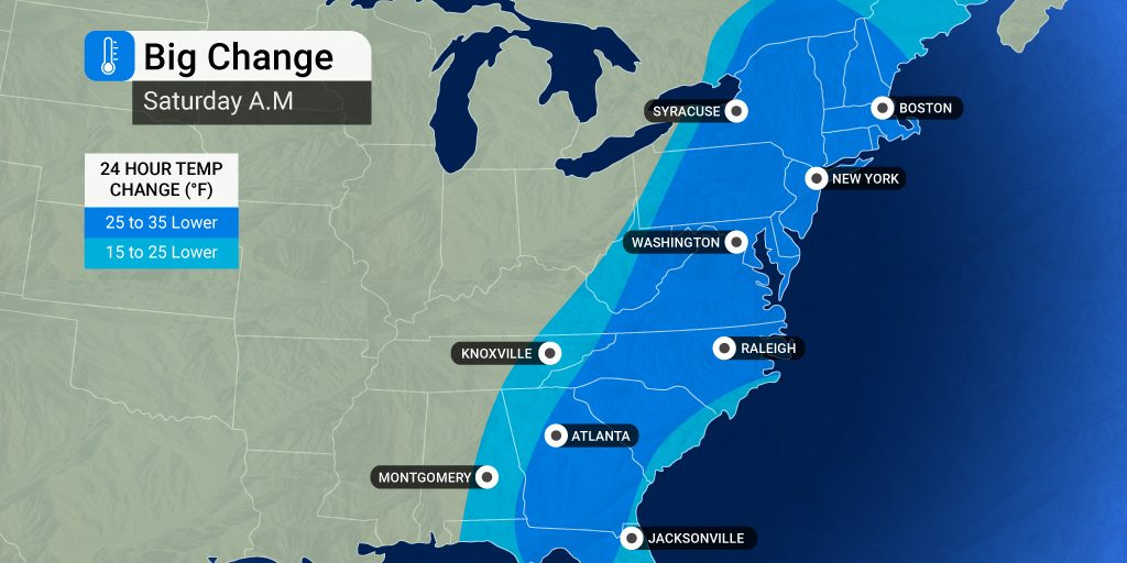
The drastic shift in temperatures will begin when a cold air mass moves to the east from the central U.S. at the end of the week, reaching the East Coast by late Friday and early Saturday. What will make it feel even colder is that the change will come on the heels of record-challenging warmth in the Northeast. For instance, the mercury will fall as much as 30 degrees for a large portion of the Appalachians to the coast, reminding residents that winter is not quite over yet.
Those in New York City should be ready for the temperature drop to take place over a period of just 24 hours, falling throughout the day Friday. While it may feel mild in the morning with temperatures in the 60s, these readings will quickly be replaced with temperatures in the 40s by the time the sun goes down. The mercury will land in the upper 20s by Saturday morning.
The current cold snap will not hold on for long, however, a series of weak storms are on the horizon beginning this weekend. This will bring more cold air back into the northern half of the country. These storms will move from the Midwest into the Northeast to start the work week.
These weather systems may generate snow or a wintry mix across parts of the Ohio Valley, the Great Lakes, and the central Appalachians starting Monday, eventually moving into the Northeast. The impacts of these small weather makers may stick around through Wednesday.
Another bigger storm will get its start in the Pacific Northwest by the middle of the week. This storm will first deliver the chance of snow in the lower elevations of Washington and Oregon before pushing to the east. This system is forecast to track into the Midwest and the Northeast by the end of next week.
The presence of cold air already in place across the central U.S. will make it more likely that snow fires up as this energy tracks from west to east. This system has the potential of creating a number of travel headaches in the air and on the roads. The chances of this coming to fruition will largely depend on how far south the mass of cold air dips.
The long-range forecast is starting to indicate that Punxsutawney Phil may have been right when we predicted another six weeks of winter a few weeks ago. Weather experts are forecasting that more vulnerabilities in the polar vortex may allow bitterly cold air to escape and head to the south. This would translate to unseasonably cold weather for the northern portions of the U.S.
For now, forecasters are predicting that the current area of high pressure anchored over the Gulf of Mexico may be strong enough to thwart the migration of the polar vortex into the U.S. However, this high pressure may not be enough in the coming weeks to prevent the Arctic air from breaking loose. As a result, the cold air may stick around in cycles in March and as late as April.
The same area of high pressure over the Gulf and the Southeast may prevent snow from igniting across the Interstate 95 corridor in the Northeast. But if this pressure weakens, the region may be at risk for spring snow storms. The timing of the cold air and the precipitation will need to be just right for the wintry weather to hang around into March and April.
It has certainly been a mild winter for the bulk of the Northeast. Only a trace of snow has been reported in cities such as Philadelphia, Washington, D.C., and New York City. Even cities that have seen their share of the white stuff are still trending well below historical averages. For instance, Boston has only recorded 7.9 inches of snow this winter, translating to over two feet below normal for this point in the season.
You will want to stay tuned to your local forecast as more details come into clearer focus about the upcoming weather makers. The bottom line is that the colder temperatures this weekend may be a harbinger of more severe winter weather on tap for later next week.
Did you find this content useful? Feel free to bookmark or to post to your timeline for reference later.

January 21, 2024

January 19, 2024

January 18, 2024
