
Heavy Rain, Flooding, and Chance of Severe Weather Staring Down the Southern U.S.
January 22, 2024
Posted: October 23, 2022 8:04 am


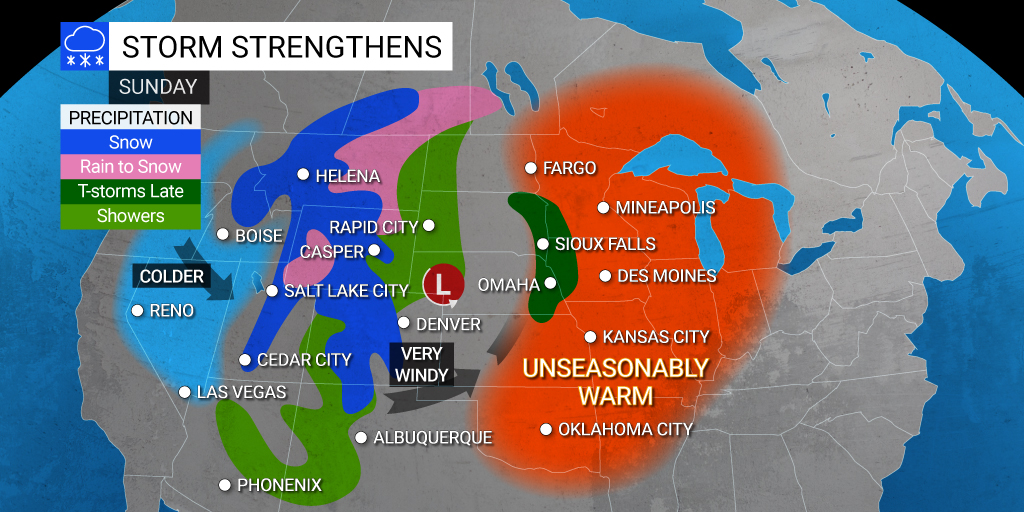
The western and central portions of the country are already seeing the impacts from a potent storm system that is sweeping through this region.
After a brief cooldown last week, the temperatures are on the upswing once again across the Plains and the Midwest. Areas such as Omaha and Kansas City saw near record breaking temperatures early last week, reminding residents that winter is indeed on the way.
However, the weekend brought readings that were as much as 20 degrees above normal for the region, making it feel more like summer again. In fact, some areas may break new records on Sunday as the mercury soars. For instance, Lincoln, Nebraska is forecast to reach 86 degrees on Sunday during the peak afternoon heating hours. This would break the 1915 record of 84 degrees. Other cities that may see records fall include Des Moines and Sioux City. This yo-yo pattern has left many people wondering what happened to fall?
While the warmer weather may feel nice to those holding on to summer, the dramatic shift will also trigger the potential of severe weather late Sunday and heading into Monday. Cities under the gun for thunderstorm activity include Kansas City and Minneapolis.
The storms will take root along a frontal boundary as a storm that is bringing significant snowfall to the Intermountain West merges with the warm air in place over the Plains and the Midwest. Those in the path for severe weather can expect strong winds, flash flooding, and hail. There is even the potential for tornadic activity.
Forecasters warn that the bulk of the severe weather could happen after the sun goes down Sunday and Monday. This means that it is even more important to enable the weather warnings on your smartphone before going to bed.
Thunderstorms are not the only threat with this storm system. The high winds associated with the system will combine with the unseasonably warm temperatures to raise the wildfire risk across the central and southern Plains. Gusts may hit as high as 90 mph as the system rolls through. Cities such as Topeka, Kansas are under a wind advisory through Sunday.
In addition to raising the fire risk, the winds will also pose a danger to motorists traveling in high-profile vehicles. This is a good time to secure all outdoor furniture or other items that may become projectiles when the wind picks up.
Monday will dawn with another threat of severe weather. However, the general impact zone will move farther to the south on this day, bringing the potentially stormy conditions to Texas, Oklahoma, and the eastern half of Kansas. This will put cities such as Oklahoma City, Dallas, Wichita, and Austin in the crosshairs of hazardous weather throughout the day. Like most storm systems of this nature, the worst of the conditions are likely to occur in the afternoon and evening hours.
For example, it will be a soggy start to the week in Kansas City on Monday with rainfall totaling about one inch. The high of about 70 degrees will hit in the morning hours before the mercury plummets rapidly as the day goes on, dropping into the 40s by the overnight hours.
It will be a stormy day in Dallas with heavy rainfall up to an inch in the forecast. The high will settle in the low 70s with breezy conditions on tap.
While the storms may disrupt travel plans and outdoor activities, this corner of the U.S. can definitely use the rain. This area has been grappling with extremely dry conditions lately.
The storm system is forecast to move to the east by Tuesday, ushering in calmer conditions to the Plains in the process. Although the threat of severe weather will dissipate with its departure, much cooler temperatures will follow behind. For example, Tulsa will see a shift of about 20 degrees for forecast highs between Sunday and Tuesday.
Did you find this content useful? Feel free to bookmark or to post to your timeline for reference later.

January 21, 2024

January 19, 2024

January 18, 2024
