
Heavy Rain, Flooding, and Chance of Severe Weather Staring Down the Southern U.S.
January 22, 2024
Posted: July 11, 2023 10:58 am


A series of storms will continue to impact the central portions of the U.S. this week, putting millions at risk of severe weather impacts. Here is a look at this developing forecast.
A large swath of the central Plains and into the Mississippi Valley is under the gun for damaging winds and heavy rainfall in the coming days as these complexes of thunderstorms take root. It has already been an unusually active severe weather season for this part of the country.
The time period from June 1 through July 4 saw over 6,400 incidents of various severe weather elements, including high winds, hail, and tornadoes. This number equates to about 34% of the yearly average over 34 days. The bulk of the activity happened in the zone west of the Appalachians and east of the Rockies.
The higher than usual amount of severe weather events is being blamed on a combination of an active jet stream over the northern tier of the U.S. along with a dome of high pressure anchored over Texas in recent weeks. The jet stream is expected to remain a hotbed of activity this week, keeping the thunderstorm threat around as heat builds in the South and the Southwest.
The storms will be most likely to ignite on the top of the heat dome. While the risk of derechos is not as high this week as it was at the end of June, there will still be a slight chance that these strong storms could develop.
Tuesday’s severe weather risk will first get going in the central and eastern portions of Nebraska before moving into South Dakota, northeastern Kansas, northern Missouri, and southern Minnesota in the evening hours. Cities in the crosshairs of the storms include Kansas City, Omaha, and Des Moines.
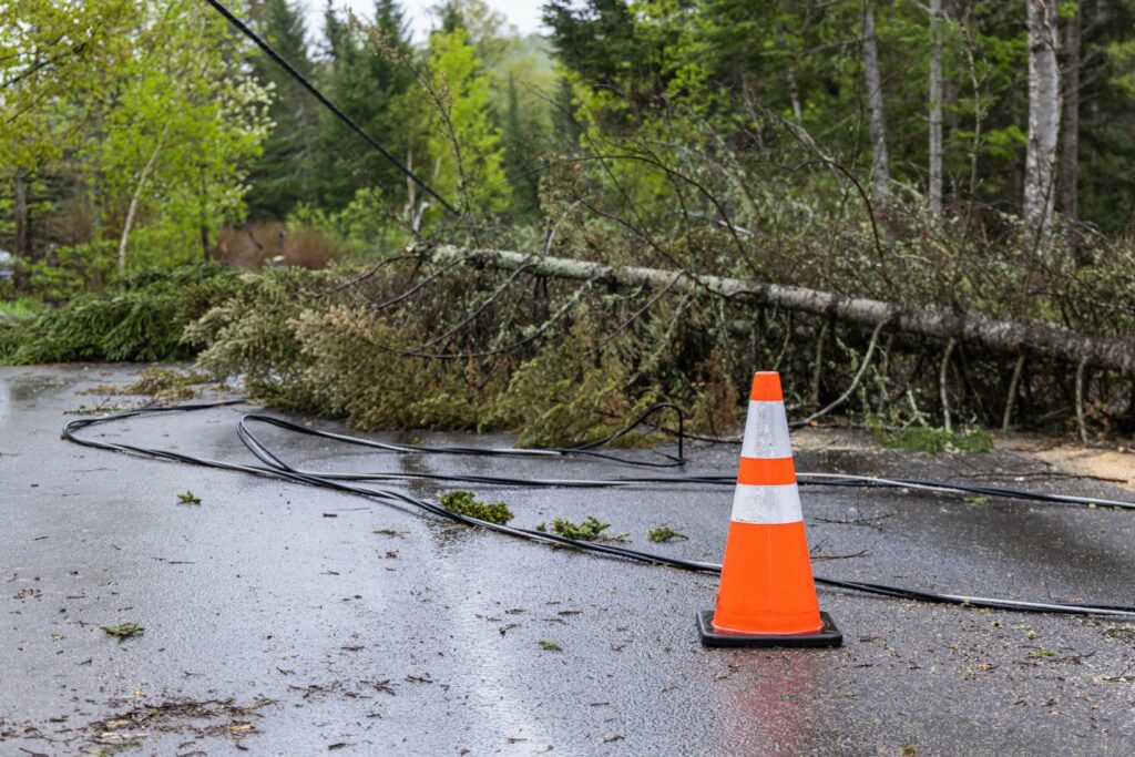
Potential impacts of Tuesday’s storm complexes include wind gusts up to 80 mph. Winds of this high speed are capable of damaging trees and bringing down power lines.
The line of storms is forecast to turn to the south on Wednesday, bringing a larger part of Missouri into the impact zone. These storms could travel into western Illinois before moving into eastern Arkansas, western Tennessee, and the northern half of Mississippi before nightfall.
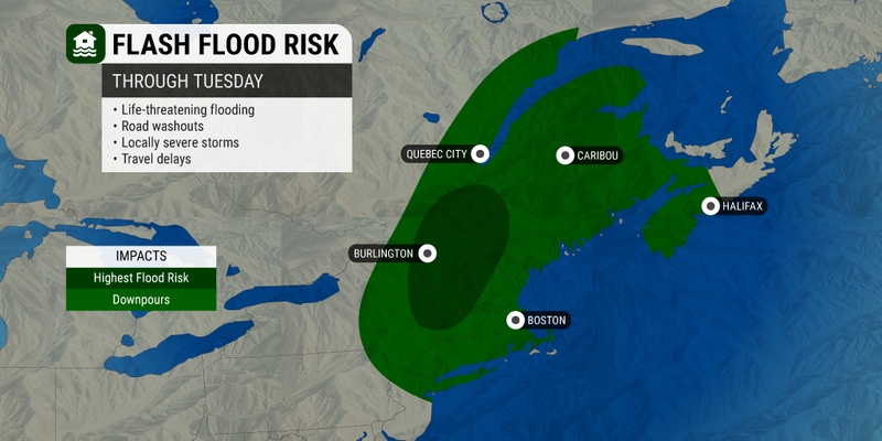
Wednesday’s storms will also deliver a good shot of torrential rain that could trigger flash flooding. Forecasters are warning that up to a half of a foot of rain could inundate this region. Rainfall amounts could hit as high as a few inches of rain in just an hour.
Major metropolitan areas at risk of Wednesday’s action include Kansas City, St. Louis, and Memphis. Motorists need to be aware of the possibility of travel delays and road closures. The significant amount of moisture associated with these storms could produce heavy rain that disrupts travel by reducing visibility and washing out roads.
Cities such as Indianapolis and Chicago will be on the edge of the storm cells. This means that while they will likely avoid the worst of the impacts, you cannot rule out the chance of a stray shower or storm impacting some outdoor activities.
The Northeast is still dealing with the aftermath of an intense rain event that started on Sunday afternoon and lingered through Monday. At least one death is being blamed on the rapidly rising floodwaters in New York state.
A drier weather pattern is on the horizon for the next few days, however, the storms are expected to return to this corner of the country by later in the week and into the weekend.
Storms may pop up in the Northeast starting Thursday and continuing at sporadic intervals through Sunday. For instance, a good chance of thunderstorms is in the forecast for places such as New York City and Boston as the work week comes to an end.
The activity will get going when the ripples in the jet stream meet up with the warm and humid air coming up from the South. Locally heavy rain may serve as a deja vu event from the prior weekend. Stay tuned for this forecast as meteorologists fine-tune their predictions in the coming days.
The lower Mississippi Valley will also be in the danger zone of thunderstorm activity by the end of the week. This threat includes the chance of a derecho.
The line of storms will shift to the east by Thursday, impacting big cities such as Atlanta. You can expect the chance of storms to linger in the Southeast through the weekend and into the early parts of next week.
While the storms are not predicted to be widespread or persistent, it may also be challenging to find blocks of time to plan outdoor activities. Checking your local hourly forecast will be your best bet when trying to plan for the weekend.
Did you find this content useful? Feel free to bookmark or to post to your timeline for reference later.

January 21, 2024

January 19, 2024

January 18, 2024
