
Heavy Rain, Flooding, and Chance of Severe Weather Staring Down the Southern U.S.
January 22, 2024
Posted: March 29, 2022 1:40 am


Residents of the southern and central U.S. are bracing for the potential of more severe weather this week. After last week brought a series of storms to the region, many Americans may find themselves at the mercy of Mother Nature once more.
The storms are predicted to ignite from an active weather pattern that brought rain to the West Coast over the weekend before dumping snow in the Rockies to start the week. This system is set to funnel down from the Rocky Mountains on Tuesday where it will clash with warm and moist air coming up from the Gulf of Mexico. The presence of unseasonably warm temperatures along the South Central region will provide the impetus needed for severe weather to take root.
Mercury readings will climb to about 10 – 20 degrees above normal for the end of March in the southern Plains states. This uptick in temperatures will create the necessary conditions for storms to fire up later in the day. The region will be ripe for severe weather outbreaks as the warm air mixes with moisture from the Gulf and the gusty winds located in the upper levels of the atmosphere.
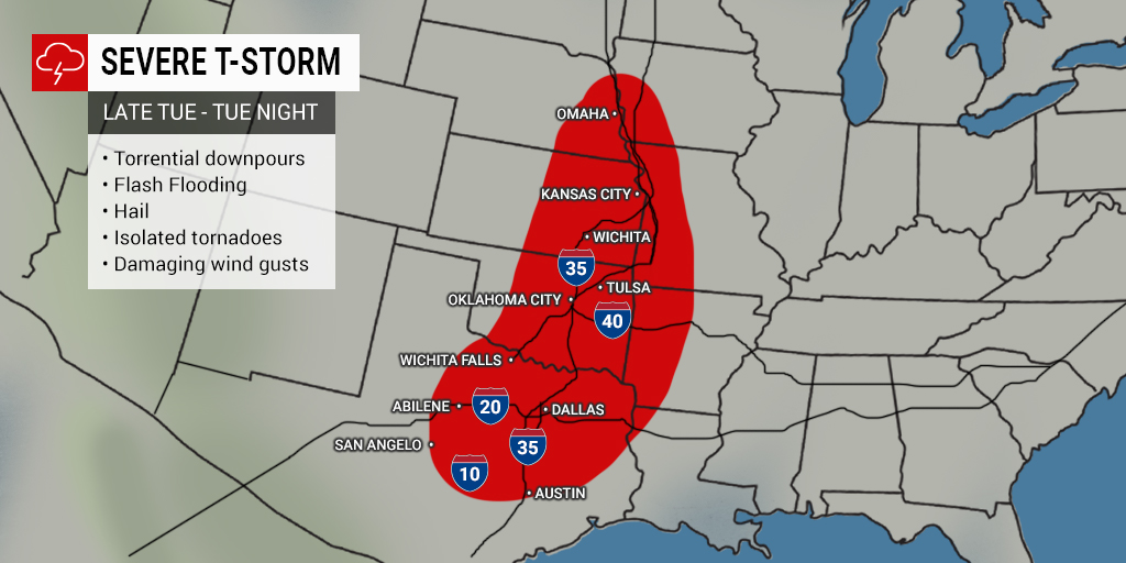
The biggest threat for severe weather on Tuesday evening and into the overnight hours will be throughout the central U.S. in Texas, up through Nebraska, and expanding into Missouri and Arkansas. This outbreak will bring the potential of a variety of conditions, including large hail, strong wind gusts up to 80 mph, and a slight chance of isolated tornadoes. The heavy rain associated with these types of storms may also lead to flash flooding concerns.
The worst of the weather is forecast to happen in the evening and overnight hours. This makes it particularly important that residents in the impacted areas set up weather alerts on their smartphones or weather radios before they go to bed. In addition to being ready for the threat of tornadoes, it is important to take care when traveling by road in the darkness of the night when severe weather is present.
By Wednesday, the threat of the severe weather will move to the east, impacting the Mississippi Valley and beyond, including some areas of the Ohio River Valley. Gulf Coast communities in Louisiana and Mississippi will feel a sense of deja vu if storms fire up in the same areas that were hit last week.
Other areas that may see strong storms fire up on Wednesday include some parts of Alabama, Arkansas, Missouri, Kentucky, Tennessee, and Illinois. The storms may ignite as early as Wednesday afternoon for metropolitan areas such as New Orleans and Nashville.
Wednesday’s severe weather events will also bring the threat of dangerous winds, hail, and isolated tornadoes. By the time the sun sets on Wednesday, the risk of storms will expand into central Alabama and the Florida Panhandle. Because the storm system is forecast to move at a fast pace, it raises the odds that many people may not be provided with a safe amount of advance warning. This makes it more important than ever to stay abreast of changing weather conditions in your area.
The bulk of the severe weather is expected to wane on Thursday. However, the system will continue its track to the east, bringing the chance of drenching rain to a large section of the Eastern Seaboard. The biggest threat of severe storms on Thursday will be positioned over the mid-Atlantic with high winds being of particular concern.
The system is predicted to move off into the Atlantic Ocean by the end of the week, bringing calmer weather in behind it.

January 21, 2024

January 19, 2024

January 18, 2024
