
Heavy Rain, Flooding, and Chance of Severe Weather Staring Down the Southern U.S.
January 22, 2024
Posted: March 29, 2023 3:37 pm


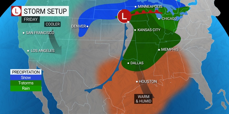
Friday is setting up to be a stormy day for over 65 million Americans in the nation’s heartland. Are you in the danger zone? Read on for all of the details.
A number of major cities will be at risk of these thunderstorms to end the work week, including Indianapolis, Chicago, St. Louis, Memphis, and Des Moines. In total, at least 15 states will likely see some form of severe weather on Friday, ranging from heavy rain, hail, strong winds, and tornadoes. The impact area will stretch as far as the Deep South into the Upper Midwest.
While forecasters had been looking at Friday as a potential area of concern since the beginning of the week, the experts have become more certain in their prediction for severe weather as the elements come into clearer focus. This includes a higher certainty that several tornadoes will form over the course of the day. The highest risk areas include portions of eastern Iowa and northern Illinois down into northern Arkansas and the western edge of Tennessee.
Tornadoes will not be the only weather risk to contend with on Friday. Strong winds may also cause damage to a large swath of the central U.S. Lastly, air travelers can expect periodic ground stops flights as severe weather rolls through.
Those in Chicago can expect the disruptions to come just in time for the evening commute. This will be the same timing for St. Louis. Areas farther east and south may not see the storms fire up until after the sun goes down.
The groundwork for these storms will be laid on Thursday as the remnants from the storm that has been impacting California come together with moisture flowing up from the Gulf of Mexico. The system will continue to grow in size and intensity overnight Thursday, making its way to the east by Friday.
Unfortunately, the threat of tornadoes will remain well after dark on Friday. Areas most at risk of seeing nocturnal storms include the lower Great Lakes and the Ohio and Tennessee valleys. These storm cells may extend as far east as the western Appalachians.
It was just one week ago that a twister tore through Rolling Fork, Mississippi under the cover of darkness, killing a few dozen people. This area will once again be in the potential impact zone this Friday. Enabling smartphone weather alerts will help you to stay informed about any developing situation.
While some parts of the country have seen their fair share of thunderstorms and tornadoes already this spring, other areas may be caught off guard by the first real severe weather of the season. This includes portions of Iowa, Minnesota, Wisconsin, and Michigan. Because of the high winds predicted with this storm system, now is a good time to secure all outdoor furniture and other potential projectiles.
Unlike previous storm systems that have stalled out over the South this March, this upcoming weather maker is forecast to move at a fast clip. This means that it is unlikely to bring significant amounts of rain. While brief torrential downpours are possible, flash flooding is not going to be a primary concern this week.
The exception to this risk will be across central and southern Wisconsin, southeastern Minnesota, and Michigan’s Lower Peninsula. Heavy snow that fell during the winter has left the grounds in this area saturated beyond what is typical, increasing the risk of flooding.
The northern edge of this system will bring the risk of snow and potential blizzard conditions to the central Plains and across the upper Great Lakes starting Friday and continuing through Saturday. Snow squalls are a possibility as the snow interacts with the strong winds.
By late Saturday, the line of severe storms will cross over the Appalachians and reach the Eastern Seaboard. Areas that can expect to see the risk of thunderstorms include upstate New York, southern New England, the mid-Atlantic, and into the Carolinas. While the odds of severe weather is not extremely high, the potential impact area covers a widespread zone.
Did you find this content useful? Feel free to bookmark or to post to your timeline for reference later.

January 21, 2024

January 19, 2024

January 18, 2024
