Heavy Rain, Flooding, and Chance of Severe Weather Staring Down the Southern U.S.
January 22, 2024
Posted: August 5, 2023 5:59 am


Over 60 million Americans are at risk of experiencing severe weather this weekend as storms are forecast to fire up across much of the Midwest and the Plains states. Here is what you need to know heading into the weekend.
It is not typical for the month of August to see widespread severe weather but forecasters are predicting that may happen this weekend as a potent storm system moves across from the northern Rockies. The areas at risk include the central Plains states, the Great Lakes, and the Ohio Valley.
The energy coming down from the Rockies will pull up moisture from the Gulf of Mexico and merge with a strong jet stream to fuel the development of storms on both Saturday and Sunday.
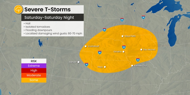
While Friday’s storm threats focused on the High Plains, Saturday’s risks will move farther to the east. This potential area of impact includes an area stretching from southeastern South Dakota and across to western Iowa, encompassing north-central Kansas, southwestern Minnesota, and southeastern Nebraska.
Cities that could see the formation of storm cells throughout the day and night Saturday include Omaha, Kansas City, and Des Moines.
The most likely threats with this line of storms include strong winds and large hail. Winds could hit as high as 70 mph during the height of the activity.
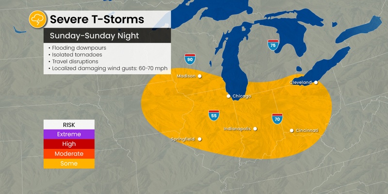
By Sunday, the threat of storms will push farther east, impacting cities such as Chicago, Nashville, St. Louis, Indianapolis, and Detroit. Sunday’s threat of severe weather will be more likely than the risk on Saturday. In addition, Sunday’s weather maker is more likely to spawn more tornadoes when compared to Saturday.
Like Saturday, Sunday’s high winds could reach speeds as high as 70 mph. Winds of this magnitude combined with the heavy rain will trigger potential travel delays across a large portion of the north-central U.S.
Flash flooding may also be an issue for parts of Nebraska, Missouri, Illinois, Kentucky, and Tennessee. These are the same areas that were hit with torrential downpours earlier in the week, making the ground more susceptible to flooding issues.

Sunday’s severe weather could create a host of travel difficulties both on the road and in the skies. Flight delays and cancellations could derail some travel plans for several major airport hubs across the Midwest, including in Chicago and Detroit. Keep in mind that travel plans could be impacted for the entire country as these are busy hubs.
As the weather shifts eastward on Monday, travelers in the Northeast should also anticipate these potential air travel disruptions. Travelers using the hubs of Pittsburgh, Philadelphia, Newark, New York City, Boston, and more could experience these impacts as the day goes on and the severe weather concerns mount.
The weekend’s weather maker will bring significant amounts of moisture for the northern Plains and the Upper Midwest as the heaviest precipitation falls along the northern fringe of the storm track. Widespread rainfall amounts of 1 – 2 inches are possible in an area from northern South Dakota through Minnesota, including Fargo and Minneapolis.
Localized amounts of up to 3 inches are also a possibility. A large part of this area is still in the midst of some level of drought. The rain will then move through a slice of the Great Lakes on Sunday night and into Monday.
While tornado outbreaks are rare in August due to the position of the jet stream, forecasters are cautioning that Sunday’s weather system could produce some isolated tornadic activity. According to the latest National Oceanic and Atmospheric (NOAA) update, Illinois currently leads the nation in the most tornado reports thus far this year.
The state will once again be caught in the crosshairs of potential tornadic activity as the weekend comes to a close.
The average number of tornadoes in a given year in Illinois is about 54, according to the National Weather Service (NWS) Storm Prediction Center (SPC). This year’s number of 125 confirmed tornadoes is the highest since 2006 when there were 144 reports.
Following Illinois this year on the list of states with the most tornadic activity is Alabama sitting at 93 reports and Texas at 78.
Did you find this content useful? Feel free to bookmark or to post to your timeline for reference later.

January 21, 2024

January 19, 2024

January 18, 2024