Heavy Rain, Flooding, and Chance of Severe Weather Staring Down the Southern U.S.
January 22, 2024
Posted: February 25, 2023 11:03 am


Rocky Start to Week for Portions of Midwest With Severe Weather on Tap
The same storm system that is hammering Southern California and much of the West this week will bring its same energy and moisture to the southern Plains and beyond by the end of the weekend. Is your community at risk of seeing severe weather out of this system? Read on for all of the details of this developing forecast.
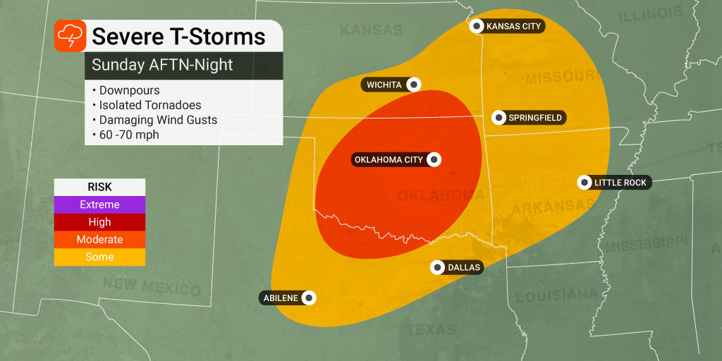
The West Coast storm is forecast to gather up more strength as it emerges over the Plains late Sunday and into Monday. The weather maker will bring a number of risks, including strong winds, large hail, torrential rain, and isolated tornadoes. Unfortunately, the time most likely to see this severe weather will fall under the cover of darkness in the overnight hours Sunday into Monday. Forecasters are urging people in the potential impact zone to enable all smartphone notifications so that they do not miss any important storm alerts.
The winds coming in from the south are forecast to intensify on Sunday, helping to draw in warm and moist air from the Gulf of Mexico. All of this will fuel the development of thunderstorms on Sunday afternoon in an area stretching from the Texas panhandle and into Oklahoma, Kansas, and the western portions of Missouri and Arkansas.
Cities that are at risk of seeing hail, tornadoes, and damaging winds include Dallas, Oklahoma City, Wichita, and Kansas City. The line of storms will intensify as it moves to the east and the northeast late Sunday night.
The risk of tornadoes will be the greatest in the overnight hours in a zone from north-central Texas into the middle of Oklahoma. The storm cells will stick around into the predawn hours on Monday, potentially giving residents of Dallas, Tulsa, Little Rock, and Kansas City an early wakeup call for the start of the work week.
This same weather maker will continue to strengthen on Monday and Tuesday, churning farther into the Midwest and the middle portions of the Mississippi Valley. By the end of Monday, you can expect some of these storm cells to reach as far as the Great Lakes and the Ohio Valley. This developing weather system will bring the possibility of localized flooding to the areas that were hit with snow and ice last week. The incoming rain mixed with the melting snow will trigger the chance of this flooding.
Cities that may see severe weather on Monday include St. Louis, Indianapolis, Louisville, and Nashville. Forecasters are cautioning that these early week storms will usher in strong wind gusts of 60 to 70 mph as well as hail and isolated tornadoes. All of these weather impacts are typical of this time of the year when winter and spring are fighting for supremacy.
Did you find this content useful? Feel free to bookmark or to post to your timeline for reference later.

January 21, 2024

January 19, 2024

January 18, 2024