
Heavy Rain, Flooding, and Chance of Severe Weather Staring Down the Southern U.S.
January 22, 2024
Posted: March 8, 2023 9:50 am


It looks as if Punxsutawney Phil was right when he predicted six more weeks of winter on February 2. At least that has held true for the north-central portion of the U.S. With another snow event on the horizon, it is shaping up to be one of snowiest seasons on the record books for this part of the country. Here is the latest on the next round of snow.
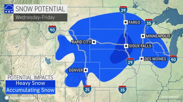
The snow is already falling in some parts of the northern Plains with more of the white stuff on the way for the end of the week. Although this snow maker is not going to approach record levels, it will be enough of a mess to trigger some travel disruptions for the region.
The greatest amount of snow is forecast to fall in western South Dakota where up to 2 feet of accumulation is a possibility. A widespread zone stretching from the northeastern corner of Wyoming through southern Wisconsin will see about 6 inches of new snow out of this late-week system.
A southward track in the storm system would bring more snow to areas of Nebraska and into central Iowa and northern Illinois. Should this track happen, travel along portions of Interstate 80 could become dicey.
There is also a chance that the major metropolitan areas of Detroit and Chicago may pick up a few inches of snow should the system track to the south. The likely timing of the snow would happen on Thursday night into Friday. A difference of just a few degrees in temperature will likely determine if the moisture falls as snow, sleet, or rain in these two cities.
Significant airline disruptions will be a possibility if the moisture falls as snow. Because Chicago’s O’Hare International Airport and Detroit Metropolitan Airport are both major hubs, the ripple effects of flight delays and cancellations could be immense.
Motorists heading out along portions of interstates 29, 35, 80, 90, and 94 should be ready for slippery or snow-covered roads by Thursday or Friday. You will want to check road conditions in this region if you have a trip planned.
Carrying on with the theme of this winter season, Minneapolis is expecting another 6 inches of snow out of this week’s system. The Minneapolis-Saint Paul International Airport has recorded 74.5 inches of snow dating back to October 1, 2022. The Twin Cities need just a few more inches to leap past the impressive total of 78.3 inches, set during the winter of 2017 – 2018. The snowiest winter in the city’s history came during the season of 1983 – 1984 when 98.6 inches fell.
By late Friday, the snow will reach into Pennsylvania, New York state, New Jersey, and the southern tier of New England. The snow may be enough to create disruptions for weekend plans.
Yet another snow storm is a possibility for early next week for the Interstate 95 corridor. Forecasters are closely monitoring two pieces of energy that could develop off the Eastern Seaboard and hug the coastal areas, ushering in more wet snow.
The weather situation will be quite different in the South. The same storm system ushering in more wintry precipitation to the northern Plains, Upper Midwest, and Northeast will bring the risks of severe thunderstorms to the southern flank of the weather maker.
Warmer temperatures will keep the moisture falling as rain in an area south of Omaha and beyond. Forecasters are not expecting widespread severe weather, however, you cannot rule out the possibility of stray storms that raise the risk of flooding. A number of major cities may experience torrential rain beginning Wednesday and lasting through Friday. These cities include Dallas, Little Rock, Nashville, and Atlanta.
A widespread 1 – 2 inches of rain is on tap with some isolated areas picking up to 4 inches by the end of the weekend. In addition to the heavy rain, these storm cells will bring the threat of damaging wind and hail.
Did you find this content useful? Feel free to bookmark or to post to your timeline for reference later.

January 21, 2024

January 19, 2024

January 18, 2024
