
Heavy Rain, Flooding, and Chance of Severe Weather Staring Down the Southern U.S.
January 22, 2024
Posted: March 10, 2023 4:18 pm


Just like what is expected in the U.S., the impacts of the current La Niña climate pattern will start to diminish in the coming months for Canada. How will this translate to what Canadians can expect for their spring weather forecast? The start of astronomical spring will happen at 5:24 pm EDT on March 20, signaling the arrival of milder conditions for the Northern Hemisphere. However, Mother Nature does not always follow the calendar’s lead. Here are all of the details of what you can expect for overall weather trends this spring for Canada.
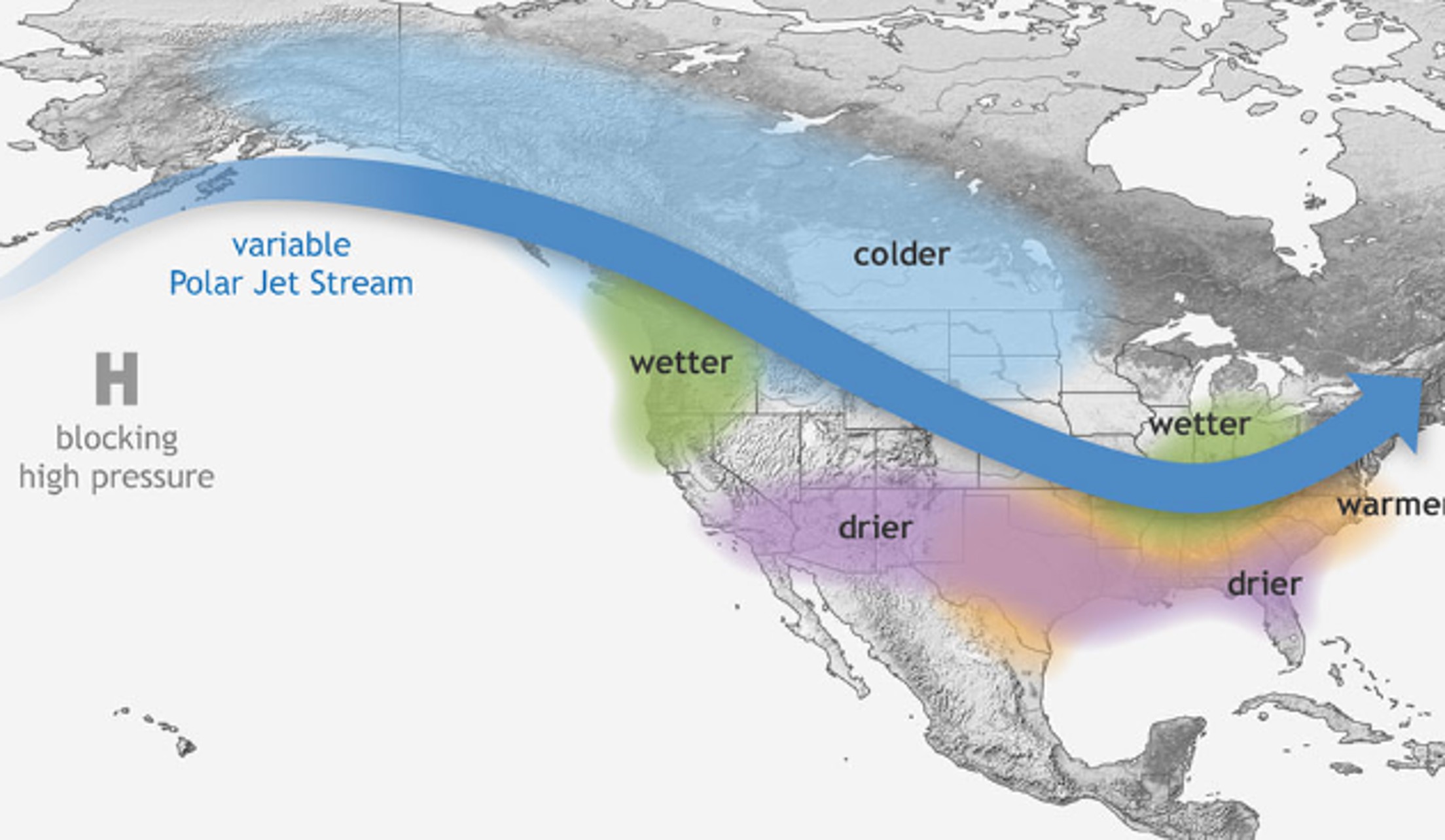
The current La Niña phase will translate to a consistent dip in the jet stream throughout western portions of Canada and into the Pacific Northwest. This position typically favors cooler air and a lingering winter season.
Although this is not welcome news for those ready to put away the coats and snow shovels, winter sports enthusiasts will appreciate the chance for a longer ski season. Temperatures are expected to average 2 to 4 degrees Fahrenheit below the historical norm for this part of Canada. This means that high temperatures of less than 60 degrees will prevail for Vancouver, British Columbia well into May.
The cold temperatures will pair with more frequent rounds of moisture for those communities closer to the jet stream. While this is the time of the year when the precipitation tends to change to rain, the transition from snow may take a bit longer. Likewise, the coastal areas of British Columbia are forecast to see more fog than is typical in the spring.
The influx of more moisture is also good news for drought conditions impacting the central and southern parts of British Columbia. Much of this part of Canada is under the designation of an abnormally dry or extreme drought.
Moving eastward, it will be dry conditions as the pervasive weather pattern for the Canadian Prairies. The mercury will hover around historical averages for the bulk of Alberta, Saskatchewan, and Manitoba. The exception to this will be the southwestern corner of Alberta, including the city of Calgary, where the temperature is predicted to remain a few degrees below normal.
It will be even colder in its neighbor to the north up in Edmonton, Alberta. This city may not be able to count on averages of 60 degrees until early June.
Areas to the east will see the temperature begin to increase right on schedule. For instance, temperatures in Winnipeg, Manitoba will come in within normal ranges for the spring months.
The biggest story in the Canadian Prairies will be the lack of precipitation. According to the North American Drought Monitor, much of this region is still in the midst of either a moderate or severe drought. Although the drought situation has improved since early last year, lower than normal rainfall in the coming months could spell trouble once again.
The one part of this region that is not under widespread drought is the province of Manitoba. Heavy snow during the past several months will likely trigger spring flooding as the snowpack begins to melt. This will be particularly worrisome for the southern tier of the province.
Spring will kick into high gear earlier than usual in the eastern half of the country. Just as the southward dip in the jet stream will bring an active weather pattern to British Columbia, it will be a similar situation for areas of Ontario. The major city of Toronto has already seen higher than average levels of moisture over the last few months.
Warmer temperatures in Toronto and beyond will keep the precipitation as rain. However, you cannot rule out the chance of snow sneaking its way back into the picture.
The warmer temperature readings have also prevented the formation of widespread ice across the Great Lakes in both Canada and the U.S. As a result, communities along these lakes will be more at risk of seeing flooding and high waves heading into the spring months. This is because the presence of ice generally inhibits the ability of high tides to create flooding along the shorelines of the lakes.
Lastly, the absence of widespread ice will also make the region more susceptible to late season lake effect snowfall. This is because cold air moving over the warmer and unprotected water on the lakes will lead to the creation of snow.
The southern and eastern portions of Ontario will also be under the gun for a higher risk of springtime flooding. Soil that is already saturated beyond normal levels may not be able to take on additional moisture.
Like Ontario, Atlantic Canada is also expected to see warmer temperatures more quickly this spring. Water temperatures in the northwest Atlantic Ocean have been trending above normal this winter. This will translate to warmer temperatures along the coastal areas of Atlantic Canada.
It has already been a mild winter for areas such as Halifax, Nova Scotia. This city will continue to enjoy the moderate temperatures. However, there is still the possibility of a late snow storm or brief influx of cold air.
Did you find this content useful? Feel free to bookmark or to post to your timeline for reference later.

January 21, 2024

January 19, 2024

January 18, 2024
