
Heavy Rain, Flooding, and Chance of Severe Weather Staring Down the Southern U.S.
January 22, 2024
Posted: November 28, 2022 10:58 am


Temperatures Will Plummet in Central and Eastern U.S. With Arrival of Storm System
Significantly colder air and high winds are in store for parts of the Midwest and Northeast on Tuesday and Wednesday as a result of the storm system currently moving over the southern U.S. The winds are forecast to be strong enough to lead to poor outages and substantial travel delays in addition to the chance of snow and bitterly cold temperatures. Here is what you need to know.
This storm system could bring damaging winds to over 125 million people as it moves down from the Colorado Rockies on Monday night on its way to the Great Lakes. The barometric pressure is forecast to plunge as the storm tracks eastward, creating gusty winds ahead of the cold front as well as behind it.
The first impacts to the central portions of the U.S. will be southerly winds that get going on Tuesday throughout the Mississippi Valley and into the coastal areas of the mid-Atlantic and New England. These winds will likely be enough to raise concerns of minor coastal flooding during high tide throughout much of the Northeast. The powerful winds from the south will also serve as the fuel for thunderstorm development in the south central U.S. on Tuesday and into the southeastern corner of the U.S. on Wednesday.
You can expect the highest winds to happen on the leading edge of the cold front and once again behind it. Winds gusting up to 60 mph are predicted on Wednesday in a large area stretching from Minnesota and into Iowa, Missouri, and up through New England and the Northeast. These damaging winds may stretch as far south as Virginia, making it likely that many Americans will be dealing with regional power outages by the middle of the week.
Residents in the line of fire should also be prepared for travel disruptions, including flight delays and turbulence. Lakeshore flooding may happen along the shores of Lakes Erie, Ontario, and Michigan.
Cities that are likely to experience strong wind gusts include St. Louis, Chicago, and Pittsburgh with the time frame happening between Tuesday night and Wednesday afternoon. The winds are forecast to begin to pick up in New York City, Philadelphia, Washington, D.C., and Boston by Wednesday night.
The storm system is predicted to pull down much colder air from Canada, bringing temperatures more reminiscent of the middle of winter than late fall. You can expect the mercury to fall between 20 and 40 degrees in the middle of the country on Wednesday when compared to Tuesday’s highs. The temperature change will go into effect on Thursday in the Northeast.
For instance, Kansas City will fall from a high in the low 60s on Tuesday into the upper 30s on Wednesday. Out East, New York City will go from a high of about 60 degrees on Wednesday to readings in the low 40s on Thursday.
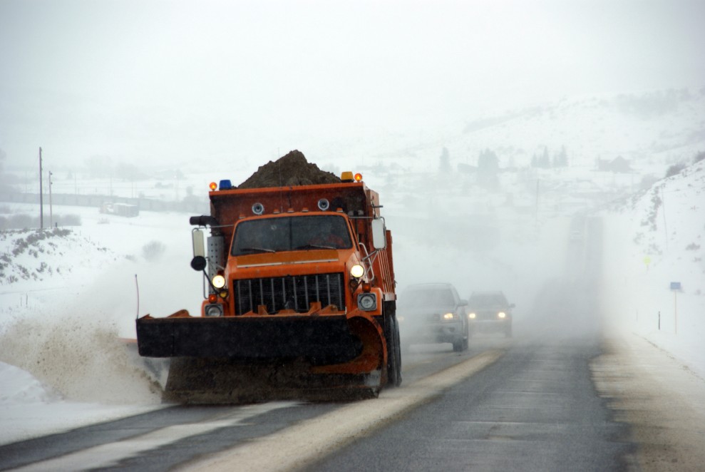
While there is not expected to be widespread snow associated with this weather, a band of wintry precipitation is forecast for the Rockies and into the Midwest late Monday through Tuesday on the system’s cold side. The Colorado Rockies will bear the brunt of the snow dump with up to 20 inches possible in the highest elevations.
The Denver area should expect at least 1 – 2 inches of snow in the city and up to 6 inches in the surrounding foothills west of the city. This threat of snow will set up late Monday and last throughout much of Tuesday. Falling temperatures in the overnight hours Monday will create icy roads and sidewalks for the Tuesday morning commute.

This snow will push to the northeast, hitting parts of the northern and central Plains on Tuesday before moving into the upper Great Lakes. This could complicate travel across Interstate 90 in South Dakota and Minnesota.
The Rockies will not be the only area that measures snowfall up to one foot. Some portions of Minnesota, Wisconsin, and the Upper Peninsula of Michigan are also forecast to see 6 – 12 inches of new accumulation. At this point, Chicago and Detroit are predicted to miss out on anything more than a few isolated flurries.
The week will also bring a good chance of lake-effect snow across the Great Lakes and into the central and northern Appalachians on the back end of the system. The interior Northeast could also experience a small amount of accumulating snow on Wednesday night. Be sure to check the road conditions if you are heading out across parts of interstates 80, 81, 87, 90, and 99 on Wednesday night.
Did you find this content useful? Feel free to bookmark or to post to your timeline for reference later.

January 21, 2024

January 19, 2024

January 18, 2024
