
Heavy Rain, Flooding, and Chance of Severe Weather Staring Down the Southern U.S.
January 22, 2024
Posted: January 4, 2023 11:20 am


The pattern of unsettled weather will continue throughout the Gulf Coast and the Southeast on Wednesday, eventually moving up into the Northeast. Here is a look back at what the region has been seeing to start 2023 and what is still yet to come this week.
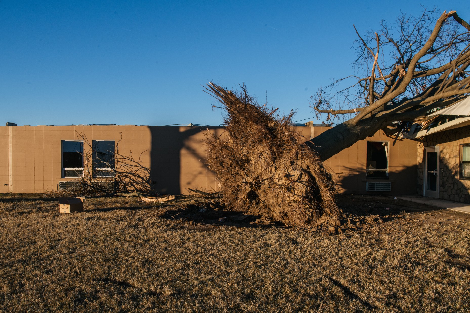
The new year got off with a bang with three confirmed reports of tornadoes throughout the South. A twister near Jessieville, Arkansas damaged at least 14 homes as well as a high school and various commercial structures. According to the Garland County Sheriff’s Office, two minor injuries were reported when trees and power lines fell on a school when students were inside.
Another tornado that evening in Montrose, Arkansas also caused a host of structural damage and left people trapped in their homes. In addition to the tornadoes, the region experienced heavy rain and flash flooding that triggered a number of vehicular accidents.
After battering the south-central U.S. and Gulf Coast on Tuesday, the storms are forecast to move farther to the east on Wednesday. This will bring the risk of storms up into southeastern Virginia and through the Northeast and down into the northern edge of Florida. Cities in the bullseye for this severe weather include Savannah, Georgia, Tallahassee, Florida, and Raleigh, North Carolina.
The line of storms will bring a host of impacts, including strong winds, the risk of flash flooding, and isolated tornadoes. It is a good idea to enable your smartphone notifications to allow weather alerts if you live in the potential impact zone.
It will be a stormy day up the Atlantic coast as well. The storms forecast to hit this part of the nation on Wednesday are still a part of the powerful system that hit the northern half of the U.S. on Sunday and Monday with snow and severe thunderstorms to the southern Plains on Monday and Tuesday. The system then tracked into the Tennessee Valley and the Mississippi Gulf Coast.
Wednesday’s threat of storms will stretch from the Florida Gulf Coast up through the central Appalachians to start the day. By the afternoon hours, you can expect storms to fire up in the Florida Panhandle and into central Virginia.
While the storms on Wednesday will not be as widespread as Tuesday’s action, the damage can be just as severe with torrential downpours and top wind gusts of up to 75 mph a possibility. Some of the storms may be strong enough to spin up a tornado or two in the afternoon and evening hours.
Motorists will want to take care when traveling on stretches of interstates 10, 20, 75, and 95. In addition to heavy rain, motorists may also be dealing with reduced visibility.
The moisture will be paired with a surge of warm air that has moved into the eastern half of the U.S. Temperatures will remain as much as 20 degrees above average for the first week of January in this part of the country. In fact, some record highs may fall on Wednesday as the mercury continues its upward trajectory before cooling off again on Thursday.
While the bulk of the severe weather will be concentrated in the mid-Atlantic on Wednesday, the storms may creep as far north as New Jersey and Pennsylvania, putting cities including Philadelphia and Baltimore in the line of fire. This will be atypical weather for a part of the country not used to seeing thunderstorms to start the year.
The end of the week will bring more seasonable temperatures to the eastern half of the country. More rain may be on tap for the weekend with some temperatures falling low enough to generate snow. Be sure to stay abreast of the local forecast in the coming days.
Did you find this content useful? Feel free to bookmark or to post to your timeline for reference later.

January 21, 2024

January 19, 2024

January 18, 2024
