Heavy Rain, Flooding, and Chance of Severe Weather Staring Down the Southern U.S.
January 22, 2024
Posted: August 23, 2023 3:00 pm


A series of severe storms are erupting across the edge of the heat dome that has been entrenched across the Midwest and into the mid-Atlantic, continuing a familiar pattern that has been in place nearly all summer. Who will be under the gun for the latest round of thunderstorms? Here are all the details for this week’s stormy forecast.
As has been the case for much of the summer, locally severe storms are predicted to ignite across the northern edge of the worst of the heat this week across the U.S. This is a typical pattern as storms are fueled by the clash of the heat and the cooler air to the north.
This week’s impacts will cover a large part of the central and eastern U.S., stretching from the Midwest and into the northern Great Lakes, the Ohio Valley, and the central Appalachians. The area directly under the heat dome is not expected to see any storm activity this week. This includes a large part of the central Plains and into the Mississippi Valley.
Instead, the greatest amount of activity will be focused on the northern fringes of the hot weather. It is important to note that this weather pattern will not yield a steady rain. The storms are more likely to be short-lived but intense, packing the potential of high winds, hail, and heavy rain at times.
The storm activity got started late Tuesday and is expected to continue at periodic times through at least Thursday. The western portions of Lake Superior and up through the northern edge of Michigan’s Lower Peninsula will be ground zero for some of these storm cells, expecting winds between 50 and 60 mph. Boaters will want to exercise caution while out on the Great Lakes with winds of this magnitude.

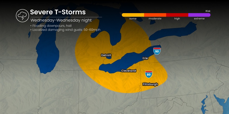
The storms are forecast to continue to move to the south and the east on Wednesday and Thursday, encompassing northern and eastern Ohio, western and central Pennsylvania, and western New York state. This means that air travel could be impacted through the busy hubs in Cleveland, Detroit, and Pittsburgh. Ground stops are possible at times as the storms push through.
Motorists in this region may also encounter difficulties heading out on the roads thanks to heavy rain that could affect visibility. You will want to pay attention to the hourly forecast if your day calls for travel on Wednesday or Thursday.
Thursday’s severe weather impacts are forecast to move farther south and back west. This will put areas such as southern Michigan, Indiana, West Virginia, western Maryland, northwestern Virginia, southwestern Pennsylvania, and the northeastern corner of Kentucky under the threat of thunderstorms. Major metropolitan areas in this potential impact zone include Columbus, Cincinnati, and Indianapolis.
Forecasters are also warning that storms could fire up across parts of the northern Plains on Thursday as a new disturbance sets up along the top of the heat dome. The Dakotas, Minnesota, and northern Nebraska could see the worst of these impacts.
In addition to these primary impact zones, parts of the mid-Atlantic and New England may also see a slight risk of storm development through Friday. These storms are not as likely to bring the same level of severe impacts when compared to the action in the Ohio Valley.
The heat dome is finally forecast to fall part by the weekend, bringing cooler air into the Midwest and beyond. Temperatures will fall to more tolerable levels throughout the central Plains and the Midwest as the result of a major pattern shift in the atmosphere.
Did you find this content useful? Feel free to bookmark or to post to your timeline for reference later.

January 21, 2024

January 19, 2024

January 18, 2024