Heavy Rain, Flooding, and Chance of Severe Weather Staring Down the Southern U.S.
January 22, 2024
Posted: March 2, 2023 3:22 pm


The work week will end with another round of severe weather in store for the South and the Ohio Valley, encompassing the Gulf Coast up through the Great Lakes. Here is what you need to know about this upcoming weather event.
The threat of severe weather has been in place through much of the southern and central U.S. over the past few days. While Friday’s outbreak is not likely to be as potent as what the region saw on Thursday, it will still produce storms that could present serious risks.
Friday’s zone of impact will center on the Southeast and the Ohio Valley. These stormy conditions are part of the same weather maker that is bringing snow to the Great Lakes. Those in the southern and central U.S. may see strong winds, heavy rain, and isolated tornadoes as the work week comes to an end.
This storm system got its start earlier in the week as it moved in from the Pacific Ocean and unleashed torrential rain and heavy snow across much of California. As it continues its track to the east, the system will dump snow on cities such as Chicago and Boston while ushering in rain and storms for areas to the south.
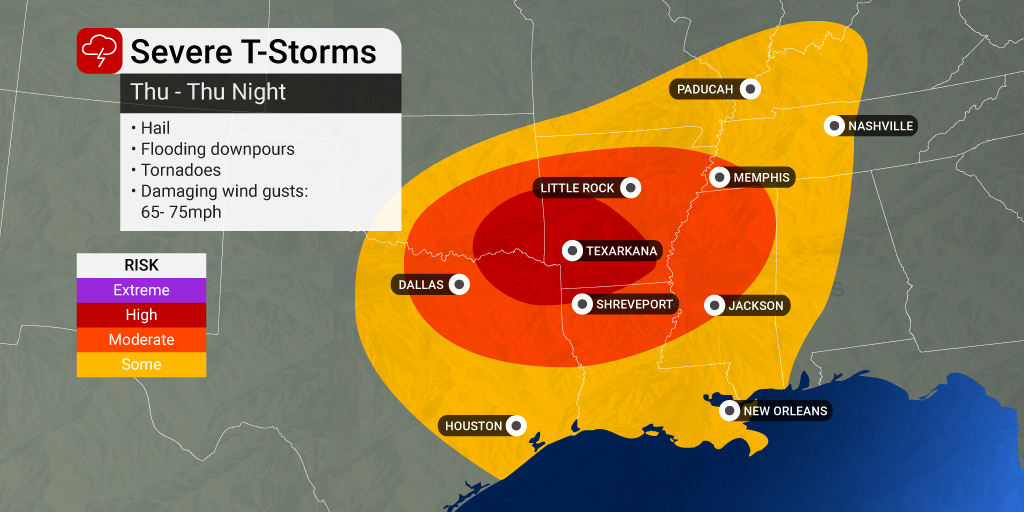
While Thursday will start on a quiet note for most of the region, the storms will fire up in the afternoon and evening hours in Texas, Arkansas, Louisiana, and into the lower Mississippi Valley. Forecasters believe that this will be the worst of the severe weather for the week, taking aim at major cities such as Dallas and Little Rock. In addition to hail as large as tennis balls, the storms may also spawn a few tornadoes.
About a dozen states will be under the threat of storm activity by the time the sun goes down on Thursday. The threat will hang on into the overnight hours, making it important to enable all smartphone notifications before going to bed. There are a number of apps that you can download on your phone that will alert you if severe weather is approaching your area.
The last day of the severe weather threat this week will bring the greatest risks to the Gulf Coast and the Ohio Valley. Unlike Thursday that started calm, Friday could get off to a stormy start thanks to the lingering weather impacts from the night before. These impacts will shift eastward, moving into Alabama and portions of Kentucky and Tennessee.
The morning commute could bring torrential rain and strong winds that clock in over 40 mph. The threat will move near the Interstate 65 corridor by noon, sending the impacts into the cities of Nashville, Louisville, and Birmingham.
As more warm and moist air comes up from the Gulf of Mexico, the threat will set up farther to the east in the afternoon hours. The storms will eventually move into the Carolinas and Georgia. The strong winds will move as far north as Ohio and West Virginia, helping to fuel more storm development through the evening commute.
Cities that may see a potentially messy commute home include Atlanta, Charlotte, and Columbus. A large portion of interstates 20, 40, 75, and 85 may experience pooling water and reduced visibility due to the storms in the region.
It will be a quieter weekend as the storms push off into the Atlantic Ocean. Be sure to get out and enjoy the weather over the weekend as a colder pattern is forecast to set up by next week. While these colder temperatures will likely tame some of the severe weather risks, it may feel like winter again for much of the eastern U.S.
Did you find this content useful? Feel free to bookmark or to post to your timeline for reference later.

January 21, 2024

January 19, 2024

January 18, 2024