Heavy Rain, Flooding, and Chance of Severe Weather Staring Down the Southern U.S.
January 22, 2024
Posted: June 6, 2022 2:56 pm


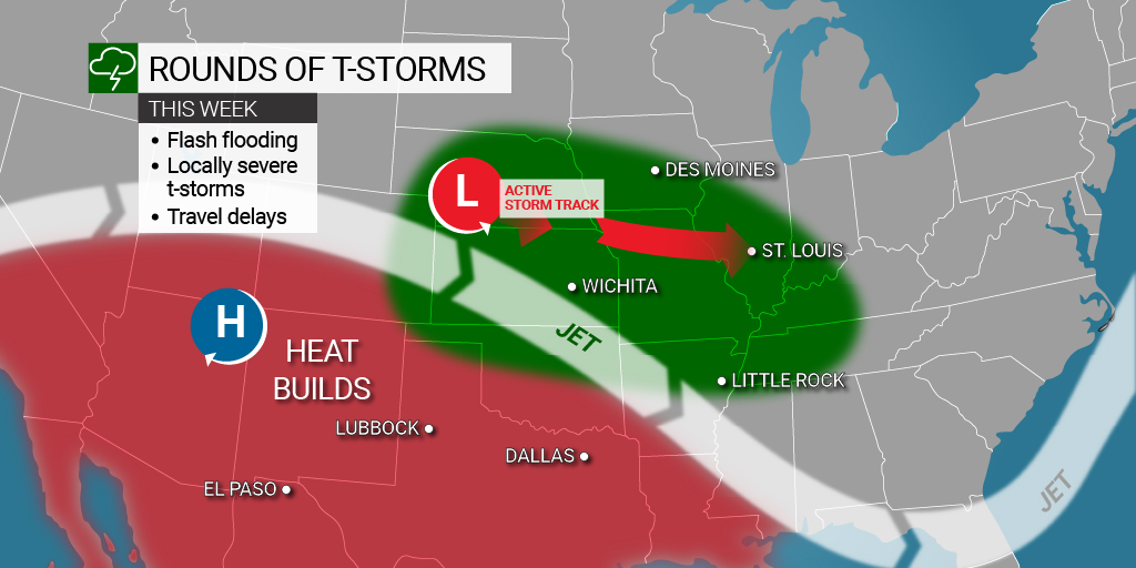
Multiple rounds of stormy weather are predicted to fire up to begin the week in a zone stretching from the Plains into the Northeast. Is your area at risk?
The calm weather conditions in the Northeast are set to come to a halt in the coming days as the stormy weather over the Plains expands to the east, bringing the chance of heavy rain and thunderstorms.
It was a weekend of unsettled weather over much of the Plains states. The Storm Prediction Center (SPC) said that it recorded almost 40 reports of severe weather on Saturday. This included two tornadoes whipping up near the border of Colorado and Kansas. Hail the size of softballs was reported in Nebraska on Sunday with more than 90 additional reports of severe weather recorded on this day.
Kansas and Oklahoma bore the brunt of the severe conditions over the weekend. This same area will see the most significant threat of weather on Monday with the storms firing up to the east of the Rocky Mountains during the evening and overnight hours. What is most worrisome to weather experts is that many of the storms this week are expected to occur in the nighttime hours. Storms that occur under the shroud of darkness are more difficult to spot, often catching people off guard, especially if they are sleeping.
Severe storms may hamper travel on Monday and Tuesday on stretches of interstates 35, 70, and 80. Winds that suddenly whip up can cause drivers of high-profile vehicles to lose control. Large hail is also a potential for these types of storm cells.
In addition to the severe weather popping up in areas such as western Kansas and eastern Colorado on Monday, another pocket of storm is expected to form across some areas of the Ohio Valley. This particular impact zone includes cities such as Memphis and Louisville. The storms will develop as a front moving to the east meets up with a mass of moisture coming from the Gulf of Mexico, triggering the development of rain showers and thunderstorms.
While this line of storms in the Ohio Valley will not likely produce large hail or tornadoes like their counterparts to the west, the area will still be under the threat of heavy rain and thunderstorms. These storms are also predicted to usher in strong winds with some gusts of up to 70 mph possible.
Parts of the Midwest will also be under the gun for persistent rain to start the week, including major metropolitan areas of Chicago and Detroit. Although there is also the chance of stormy conditions, these weather makers are not likely to deliver any significant risks.
While this section of the Plains will still be under the threat of storms on Tuesday, the line of severe weather will expand up into western Nebraska and down into eastern New Mexico. Similar to Monday’s weather pattern, Tuesday will also bring the strong chance of wind, hail, heavy rain, and isolated tornadoes. Be sure to enable all severe weather alerts on your phone if you live in this potential impact zone.
According to the U.S. Drought Monitor, a great majority of the western Plains states are under some designation of drought. While these large thunderstorm cells will deliver beneficial rain, the precipitation coming down at such a fast clip can instigate flash flooding.
As the day progresses Tuesday, the storms will move farther to the east, eventually reaching the Northeast and cities such as Pittsburgh and Washington, D.C. This will bring to a close the pleasant conditions that the region has enjoyed over the last several days. Although these storms are also not likely to bring substantial risks, they will bring a heavy dose of moisture.
It will not be unusual for some of the area to see minor flooding, especially in low-lying locations and those with poor drainage. Humidity levels are also expected to increase as this moisture from the Gulf filters into the region. Combined with the increasing heat of this time of the year, it may feel uncomfortable for some individuals.
Did you find this content useful? Feel free to bookmark or to post to your timeline for reference later!

January 21, 2024

January 19, 2024

January 18, 2024