Heavy Rain, Flooding, and Chance of Severe Weather Staring Down the Southern U.S.
January 22, 2024
Posted: November 7, 2022 2:31 pm


Just as forecasters predicted a few weeks ago, the Atlantic basin has remained active heading into the end of the hurricane season. Subtropical Storm Nicole formed on Monday in the southwestern Atlantic Ocean. Where is this storm headed? Read on for all the details.
The National Hurricane Center (NHC) kept busy this weekend watching a tropical rainstorm that developed on Saturday near Puerto Rico. The island territory was hammered with several inches of heavy rain before the system moved into the Caribbean Sea early Sunday.

The system was able to find the favorable environmental conditions that it needed to strengthen throughout the day Sunday. The feature was anointed as the 14th named storm of the 2022 Atlantic season on Monday morning. Forecasters are predicting that Nicole will continue this intensification, taking on fully tropical characteristics before it moves closer to the northern Bahamas and South Florida.
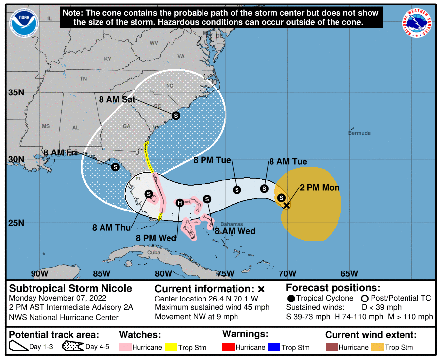
By late Monday morning, Nicole was boasting sustained winds of 45 mph as it churned 495 miles southeast of the northwestern Bahamas. Nicole is a large system with tropical storm-force winds reaching out 275 miles to the east of the storm’s center. The feature is moving at a speed of 9 mph toward the northwest.
Due to its predicted trajectory, authorities have issued a hurricane and storm surge watch for the eastern coast of Florida. In addition, a tropical storm watch is now in effect for the islands of the northwestern Bahamas.
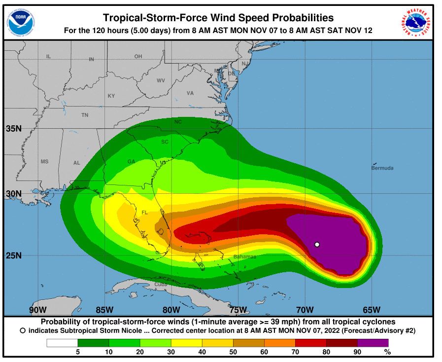
Hurricane experts are warning that Florida will be under the gun for heavy rain and strong winds along the Atlantic coast. Nicole is predicted to move across the peninsula before turning back to the north along the Eastern Seaboard, eventually reaching Atlantic Canada by the weekend. This path will put millions of people in the impact zone.

Before hitting the U.S., Nicole is predicted to bring a general amount of 1 – 2 inches of rain to the Lesser Antilles and the Leeward Islands. This part of the basin will be at a higher risk of flooding and mudslides because it has already been deluged with significant rainfall in recent weeks.
The outer bands of the system should begin to impact the Bahamas and Florida by the middle of the week. This is because the storm is predicted to shift from a northward path to a westward track late in the day Tuesday.
Heavy rainfall and flash flooding are not the only concerns with this system. The strong winds are forecast to begin to pick up in the northern Bahamas and throughout much of Florida late Tuesday and and into Wednesday. The current models show the storm making landfall somewhere along the southeastern coast of Florida late Wednesday or Thursday morning.
All areas along the Sunshine State’s east coast should keep abreast of the developing storm as it approaches in the coming days. Wind gusts of up to 60 mph could move far inland into the peninsula, bringing the potential of downed power lines and trees to Fort Lauderdale, Jacksonville, and as far inland as Orlando.
Forecasters are predicting that the system will devolve into a tropical depression by the end of the week as it continues to interact with land. The latest projections show the system becoming a tropical depression as it moves into the Southeast.
By the end of the week, the depression will likely take a northeastern path. This movement will bring it along the southeastern coast of the U.S, including Georgia and the Carolinas.
Although the feature will continue to lose steam as it moves back out into the Atlantic Ocean, it will still have enough energy to bring rain and winds to much of the Eastern Seaboard and into Atlantic Canada. In addition to the heavy rain and strong winds, the eastern coast of the nation should be ready for widespread coastal flooding, dangerous rip currents, and minor beach erosion.
Despite the official hurricane season coming to an end on November 30, the month has already spawned three named storms with Nicole joining Lisa and Martin on the list.
Did you find this content useful? Feel free to bookmark or to post to your timeline for reference later.

January 21, 2024

January 19, 2024

January 18, 2024