
Heavy Rain, Flooding, and Chance of Severe Weather Staring Down the Southern U.S.
January 22, 2024
Posted: May 3, 2023 3:01 pm


Those tired of the cool weather in the Midwest and the Northeast are in luck. A warming trend is on the horizon for this part of the country, ushering in more seasonable conditions by the weekend.
It has felt more like late winter than the middle of spring for the Midwest and the Northeast over the last few days. Some parts of the Upper Midwest even saw accumulating snowfall to start the week.
However, a change is on the way as warmer air is predicted to move from west to east, delivering weather that is more typical of early May.
The complicated jet stream setup known as an Omega block is expected to break down by the middle of the week. This will encourage a more traditional weather pattern with the mercury on an upward trajectory.
In fact, the temperatures could rebound by as much as 40 degrees when compared to the unseasonably cold readings earlier this week.
When can you expect the warmer temperatures to make their move? The Midwest will begin to see a bit of a warmup on Wednesday. After seeing readings hovering in the upper 40s on Tuesday in Chicago, the temperature will come close to hitting the 60-degree mark Wednesday afternoon.
Those in the Windy City can look forward to temperatures in the upper 60s by the weekend, trending about 5 – 8 degrees above normal for this time of the year.
It will take a little longer for the warmth to reach the East Coast. Temperatures may see the 70-degree threshold by Sunday in New York City with even warmer readings in store for the start of the next work week.
While Boston is not forecast to sniff the 70s, it will still be a pleasant weekend with mostly sunny skies and highs in the mid 60s.
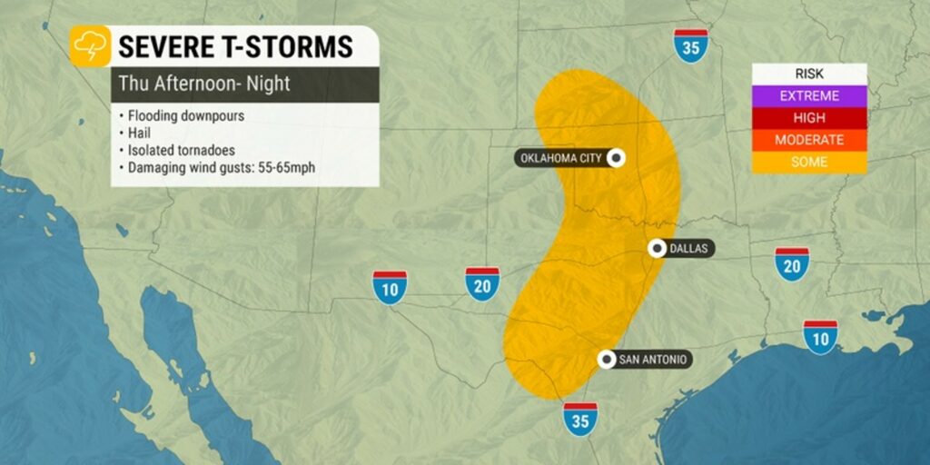
As the Northeast is enjoying a nice weekend, a storm from the West Coast will be making its way into the Plains states. This system will be fed with a steady stream of moisture from the Gulf of Mexico, bringing the chance of thunderstorms in an area from Texas and up through the Dakotas.
Thunderstorms will remain a threat for days for places such as the Dallas-Fort Worth metroplex. The threat of storms may not reach the northern Plains until later in the weekend. For instance, Omaha will enjoy a nice and dry day on Saturday before the storms are forecast to fire up on Sunday.
The constant presence of moisture will also raise humidity levels, sending the real feel readings higher across the central U.S. this week. Be prepared for real feel temperatures to land as high as 90 degrees across some portions of the Ohio Valley and the Great Lakes.
The long-range forecast is calling for more periods of unseasonable warmth across the eastern half of the country through at least the middle of May. This pattern will also deliver a higher chance of thunderstorm development over the nation’s heartland.
While this heightened storm activity presents its own set of hazards, it is also good news for portions of the central U.S. still dealing with ongoing drought conditions.
Local officials have been keeping a close eye on the potential flooding situation along the Upper Mississippi River. Major flooding has been an issue across the Mississippi River along the border of Illinois and Iowa. The flooding is the result of the rapid snowpack melt from a late-season snowstorm in early April.
The good news is that the middle section of the Mississippi River Valley and the Missouri River watershed are not expected to be dealing with flooding issues in the coming weeks. Water levels are predicted to remain at low or normal levels in areas such as St. Louis.
Did you find this content useful? Feel free to bookmark or to post to your timeline for reference later.

January 21, 2024

January 19, 2024

January 18, 2024
