Heavy Rain, Flooding, and Chance of Severe Weather Staring Down the Southern U.S.
January 22, 2024
Posted: August 3, 2023 3:00 pm


The onslaught of daily thunderstorms is set to continue through the central U.S. this week, putting the region on high alert for flash flooding due to the repeated downpours. Here is the latest on this stubborn weather pattern that continues to impact the nation’s heartland.
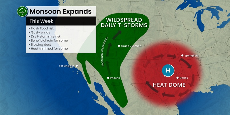
It has been a rocky week for the central U.S. as several storms have popped up along the northern ridge of the heat dome that has been positioned over Texas all week. This mass of energy has been responsible for daily thunderstorms packing high winds, hail, lightning, and heavy rain. Forecasters are also warning that isolated tornadoes may spin up as a result of these disturbances.
Some communities may be hit with multiple rounds of storms through the end of the week, raising the risk of flash flooding. The primary impact zone for the repeated storm activity will be across eastern Colorado, southeastern Wyoming, western Kansas, Nebraska, and southern South Dakota.
This zone includes the Denver area. The Mile High City will be under the threat of storms packing small hail and gusty winds late Thursday. While it will calm down for the weekend, the storm train is forecast to get going again on Monday. This is a typical weather pattern for this time of the year when the monsoon moisture coming from the Southwest starts to ramp up.
While this zone will likely see the worst of the impacts, it is important to note not that every area will see daily storms. In addition, the storms could travel out of this zone.

Another part of the U.S. that needs to be aware of the potential of life-threatening flash flooding is the northern Rockies. While it will dry out in time for the weekend, it could be a soggy Thursday for much of the interior West. Vacationers visiting Yellowstone National Park may see a washout with persistent rain in the forecast.
Jackson, Wyoming is bracing for thunderstorms throughout the day on Thursday. It will also be cool with the mercury topping out in the low 60s for a high. Temperatures will drop to the 50-degree mark after the sun goes down over the Tetons. Although it will be slightly warmer on Friday with a forecast high of 70 degrees, the rain could still be a hindrance to spending time at the parks.
This part of the intermountain West is particularly susceptible to flooding this time of the year because of the steep terrain. It does not take much rain for rapid runoff to overwhelm the many streams in the region. This makes it even more important for park goers to listen to warnings and pay attention to changing weather conditions.
You can expect the storms to push eastward just in time for the weekend. The highest risk of storm activity on Saturday afternoon and evening will stretch into southern Minnesota and across Iowa.
By Sunday, a number of major cities may be under the gun for storms to erupt, including Chicago, Detroit, and Indianapolis. While it is still too early to pinpoint with accuracy, these storms could pack quite a punch. You will want to keep an eye on this developing weather situation if you live in this part of the Midwest or the Great Lakes.
It will be the Northeast that may be dealing with disruptive storms to start the work week. Locally severe storms could ignite across the upper Great Lakes region through the first part of the week.
Flash flooding is going to be the biggest concern with the storms over the next several days. While the winds could lead to property damage or power outages, forecasters are warning that the heavy rain will likely end up being the most significant disruption.
Forecasters will be staying on top of the flooding chances in an area encompassing southeastern Nebraska, much of Missouri, southern Iowa and Indiana, and portions of Kentucky and Tennessee. The flooding risk could extend as far south as northern Georgia and the Carolinas through Saturday.
Cities that could be at risk of flooding include Nashville, St. Louis, Omaha, and more. A general 2 – 4 inches of rain is forecast to fall with this system, however, some isolated areas could see up to 8 inches of precipitation. Complicating the flooding risk will be the fact that the rain could fall quickly over a short amount of time. This is a good time to ensure that all weather alerts have been enabled on your smartphone so that you can stay abreast of any potentially dangerous situations.
Some areas may also be hit with repeated downpours, raising the risk of flooding. The most likely zone to see the torrential rain on more than one occasion includes the southern Appalachians and the middle Mississippi Valley.
The Gulf Coast may also see some of the storm cells drift in their direction into early next week. For instance, Monday is shaping to be a stormy day for New Orleans. Farther to the north, Jackson, Mississippi could get hit with storms on Saturday and again into next week.
The bottom line is that these sporadic storms are going to impact much of the middle of the U.S. well into next week.
Did you find this content useful? Feel free to bookmark or to post to your timeline for reference later.

January 21, 2024

January 19, 2024

January 18, 2024