Heavy Rain, Flooding, and Chance of Severe Weather Staring Down the Southern U.S.
January 22, 2024
Posted: August 6, 2021 1:04 am


NOAA Revises its Hurricane Forecast Upwards as Atlantic Heats Up
Is the Atlantic basin finally coming to life after a traditional mid-summer break from the tropical activity? Forecasters at the National Hurricane Center (NHC) are closely watching a few areas of potential development as the peak of hurricane seasons quickly approaches.

There are a few reasons that are helping to spur an increase in tropical storm development. The dry air masses that have suppressed tropical activity in the Atlantic over the last few weeks have now started to dissipate, ushering in the moist air that is more conducive for development. In addition, the dust that travels off the Sahara Desert and over the Atlantic is also starting to lift, clearing the way for tropical storms to take root. Lastly, the typical hindering wind shear present in July is beginning to break up. Together, all of these factors deliver an environment that is more conducive for tropical activity.
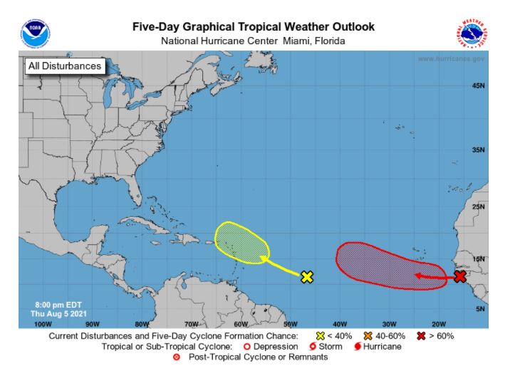
Forecasters have their eyes trained on a tropical feature that has a 70% chance of further development. This wave is now moving off of the coast of Africa in a westerly direction. Assuming that the wind shear continues to diminish as expected, the wave stands a good chance of intensifying over the coming days.
The wave is moving into an area of moist air, delivering the needed impetus for storms to become more organized. The feature is also going to encounter warmer water temperatures through next week. This will serve to support further development if the feature stays on its current trajectory.
In addition to the wave moving off of Africa, there is another feature that is positioned ahead of it. At this point, the closer wave appears weaker in organization and intensity. However, there is a strong chance that this feature will interact with a different non-tropical system in the region, raising the risk of development as it approaches the Lesser Antilles.
Unlike the wave closest to Africa, this secondary development will likely be weakened by wind shear in the area. The presence of dry air may also inhibit its potential for growth.
Fred and Grace are the next two names for the 2021 Atlantic hurricane season.
Although the number of new tropical storms has slowed down in July, the 2021 Atlantic season is still ahead of pace through the month of July. There have been five named storms in the Atlantic so far in 2021. According to historical data from the NHC, there are normally three named storms by mid-August.
Hurricane Elsa formed on July 5, taking four days to fully burn out as it made its way across Florida and up the East Coast. A time of calm followed Elsa’s destruction with no new named storms in the area between July 10 and August 3. It was the first time since 2009 that there were no named storms during this time period.
With the peak of hurricane season still one month away, forecasters warn that now is not the time to get complacent. Most long-range forecasts predict that there will be more direct impacts to the US before the season wraps up.
On Wednesday, the National Oceanic and Atmospheric Administration (NOAA) Climate Prediction Center revised its initial May forecast by increasing its confidence that the season will still end up with more storms than average. The revised forecast now predicts 15-21 named storms. This is an increase from the May prediction of 13-20.
NOAA is also predicting seven to 10 hurricanes, up from the first forecast of six to 10. Of this number, three to five are predicted to be either Category 3, 4, or 5 storms.
The official hurricane season does not end until November 30, leaving plenty of time for these predictions to come to fruition.

January 21, 2024

January 19, 2024

January 18, 2024