
Heavy Rain, Flooding, and Chance of Severe Weather Staring Down the Southern U.S.
January 22, 2024
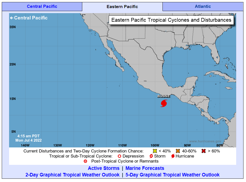
Posted: July 3, 2022 7:26 am


Tropical Storm Bonnie formed near Central America on Friday, kicking off the month of July with a bang in the Atlantic basin.
As the second named storm of the 2022 Atlantic season, Bonnie took a unique path through the southern reaches of the Caribbean before barely skirting the northern coastal areas of South America. The storm is now expected to head toward Nicaragua and Costa Rica with an anticipated landfall sometime late Friday.
Hurricane experts say that the window is quickly closing for the tropical storm to develop into a hurricane prior to landfall. While it has gained strength throughout the day Friday, it will not likely find the fuel that it needs to reach hurricane status.
As of mid-afternoon Friday, Tropical Storm Bonnie was positioned about 150 miles to the east and southeast of Bluefields, Nicaragua. According to the latest data from the National Hurricane Center (NHC), the storm was moving to the west at a fast pace of 20 mph. Bonnie was boasting maximum sustained winds of about 40 mph with these gusts extending about 115 miles outward from the center of the storm.
After meandering around in the Caribbean throughout the week, it took some time for the system to develop into a named tropical feature. Its strengthening was slow as it lost intensity after moving over the northern coasts of South America. However, once it moved past this landmass and into the open and warm waters of the Atlantic, the feature was able to begin to strengthen and officially take on tropical storm characteristics.
Tropical Storm Bonnie is forecast to move across the southern tier of Nicaragua and the northern part of Costa Rica on Friday night. The storm is predicted to move onto land with maximum sustained winds measuring between 50 and 60 mph. A tropical storm warning is in effect for these areas as the storm inches closer.
The region is forecast to see the threat of flooding rainfall and damaging winds well into Saturday. The southern edge of Nicaragua is expected to see the most intense winds with gusts measuring 60 – 80 mph starting late Friday and continuing into the next day.
Rainfall between 8 – 12 inches will inflict a large swath of land between southern Nicaragua and northern Costa Rica. Areas outside of the primary impact zone can expect to see rain totaling about 4 inches. This includes nearly all of Nicaragua and farther into Costa Rica.
Residents and visitors need to be ready for significant flooding as a result of this rain. The region’s higher terrains will be at risk for dangerous mudslides if the rain comes down quickly enough. The good news is that if the storm continues its swift journey, it will be less likely to drop significant amounts of rain that lead to mudslides.
Even as a mere unnamed tropical rainstorm, this feature has disrupted life for parts of Venezuela and the island of Curacao over the last few days. The storm also caused power outages earlier in the week across the islands of Trinidad and Tobago.
Tropical Storm Bonnie is not expected to weaken significantly as it moves over Central America. The storm will eventually emerge in the eastern Pacific some time late Saturday. Because the storm is tracking to the south of the highest terrains of the region, it has a higher chance of staying together. This means that forecasters believe it will remain a tropical storm as it moves into the Pacific Ocean.
Once it reaches this ocean, it will find conditions that are favorable to further development. Forecasters are predicting that the storm will reach hurricane status by early next week as it meanders to the southwest of the coast of Mexico.
This part of the Pacific Ocean has already seen two named hurricanes this season with Agatha and Blas.
Did you find this content useful? Feel free to bookmark or to post to your timeline for reference later!

January 21, 2024

January 19, 2024

January 18, 2024
