
Heavy Rain, Flooding, and Chance of Severe Weather Staring Down the Southern U.S.
January 22, 2024
Posted: June 20, 2023 3:00 pm


The second tropical storm to take root in the Atlantic basin this season is forecast to transition into a hurricane as it crosses into the Caribbean Sea at the end of the week. Here is the latest on Tropical Storm Bret, including what the models are saying about potential impacts to the U.S.
Tropical Storm Bret formed in the central Atlantic on Monday just a few hours after it was designated as a tropical depression. The fast intensification of this tropical feature has attracted the attention of the National Hurricane Center (NHC).
The NHC said that it will continue to move to the west in the coming days, finding a pocket of atypically warm ocean waters as it makes its journey across the Atlantic.
As of Tuesday morning, Bret was churning about 945 miles east of the Windward Islands. The storm is packing maximum sustained winds of about 40 mph as it moves in a westward direction at a speed of 21 mph. The latest round of satellite images of the feature indicate a robust and growing system.
The organized block of showers and storms took on the name Bret when its maximum winds hit 39 mph. The current models project that the system may become the first hurricane of the 2023 Atlantic hurricane season as it approaches the eastern Caribbean in the next few days.
Bret is a bit of an anomaly for this part of the Atlantic basin this early in the season. Originating as a tropical wave coming off the coast of Africa, these systems in the south-central Atlantic typically do not develop until later in the season when the ocean waters become warmer.
Tropical Storm Bret will likely find favorable conditions to grow as it makes the trek across the Atlantic. The current ocean water temperatures in the zone stretching from the Cabo Verde Island to the Windward Islands are running between 80 and 82 degrees, slightly over the minimum threshold needed for tropical development to occur.
Bret is also moving into an area with a substantial amount of hot air to further fuel its development. These elements will provide the necessary ingredients for the storm to organize and potentially hit the designation of a hurricane.
One wild card expected to impact the storm’s progress is the amount of wind shear that it encounters. Low levels of wind shear support intensification of tropical features while high amounts of wind shear hinder their development.
As of now, forecasters are unsure what degree of wind shear levels will be in place as Bret jogs through the Atlantic.

The closest major landmass in the path of Bret at this point is the area around the eastern Caribbean islands. Residents and travelers to this part of the Atlantic will want to keep a close eye on the progress and direction of Bret.
Forecasters say that there is a chance that the jet stream dips off the coast of the U.S to a degree that it brings Bret to the north. Should this dip in the jet stream not take place, Bret will continue in a line straight to the west.
The Windwards and Leewards will see the first major impacts, beginning late Thursday and into Friday. These eastern Caribbean islands will want to be aware of the potential of heavy rain and winds strong enough to bring down tree branches and power lines.
Depending on how quickly and to what degree this storm intensifies, it could also create flash flooding concerns in low-lying areas. Rough surf conditions are also likely with a storm of this magnitude.
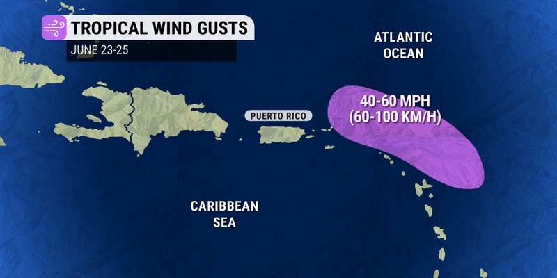
Wind gusts are expected to top out at about 100 mph for islands in its path. The rainfall totals are expected to hit up to 8 inches in areas such as Hispaniola and Puerto Rico. However, hurricane experts caution that it is too early to determine how much rain this system will produce and where the worst impacts will land.
Tropical Storm Bret is not the only tropical feature that has drawn the attention of the NHC. A different tropical wave right on the heels of Bret is also being monitored for future development this week.
As of now, the NHC puts the odds of this cluster of storms developing into a tropical depression or storm at a medium chance. The next name on the list of monikers for the 2023 Atlantic hurricane season is Cindy.
In addition to these features in the eastern Caribbean and beyond, another area of low pressure spinning near Central America is also being studied. The NHC said that a more organized system may spring up from this area later in the week, sending tropical moisture northward and to the Florida peninsula.
Lastly, an area in the East Pacific basin off the coast of southwestern Mexico has also been generating a large zone of showers and thunderstorms. While there is still a chance that this disturbance could take on tropical characteristics, those odds are waning with each passing day. It is also not likely headed toward any major areas of land.
Did you find this content useful? Feel free to bookmark or to post to your timeline for reference later.

January 21, 2024

January 19, 2024

January 18, 2024
