
Heavy Rain, Flooding, and Chance of Severe Weather Staring Down the Southern U.S.
January 22, 2024
Posted: August 24, 2023 3:00 pm


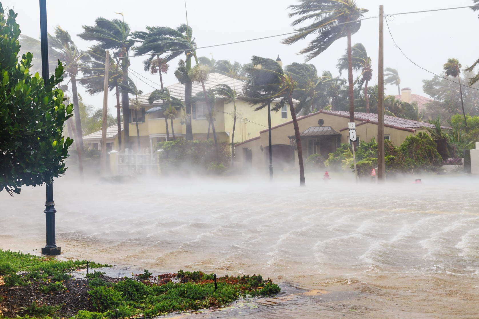
It is going to continue to be a busy time in the Atlantic basin as tropical weather activity sees a significant uptick. Tropical Storm Franklin came to life earlier in the week, dumping heavy rain across portions of Puerto Rico and Hispaniola. What is next for this feature and what else does the Atlantic have up its sleeve heading into the peak of the 2023 hurricane season? Read on for all of the details.
Experts at the National Hurricane Center (NHC) will be kept busy in the coming days monitoring areas for potential development across the basin. The typical peak of the season is September 10, meaning that it is not unusual for this part of the Atlantic to see heightening amounts of activity. There have been three named systems churning in the Atlantic at two separate times in the past week alone.
Franklin is expected to survive after weakening over the higher terrains of Hispaniola. The mountains towering up to 10,000 feet across the Dominican Republic worked to break apart the circulation associated with Franklin. However, forecasters believe that Franklin will stay intact long enough to find the right environmental conditions needed to strengthen again as it moves to the north of the Caribbean.
While it is likely that Franklin will weaken into a tropical depression or rainstorm over the next day or two, it may also reorganize and intensify by the weekend as it cruises over the open waters of the Atlantic.
Franklin is also predicted to slow down and start to move more to the northwest. The storm could hit the official designation of a hurricane as this happens late Friday and into Monday. The current models also indicate that a lesser amount of wind shear starting this weekend could support further development, possibly sending Franklin up to the status of a Category 2 hurricane or higher.
At this point, Franklin is forecast to skirt well west of the Bermuda islands. However, the unpredictability of these features means that interests in and around Bermuda should keep a close eye on the track of this storm. Franklin’s speed and timing of the turn to the northwest will influence how close it comes to Bermuda.
This track will depend on a number of other unrelated weather events. This includes the arrival of a cool front pushing across North America and the position of an area of high pressure anchored over the central portions of the Atlantic. It may not be until this weekend until the track becomes more clear. For instance, should Franklin move farther to the east, Bermuda could feel the impacts in the form of torrential rain and high winds.
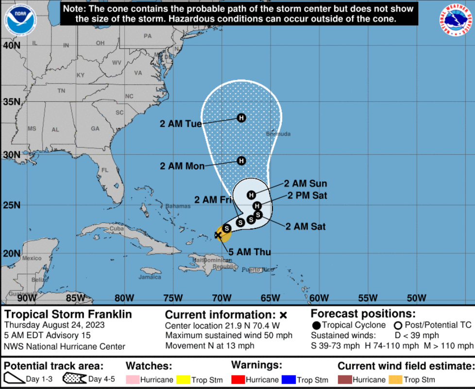
The most recent forecast indicates that the U.S. will dodge all of Franklin’s major impacts. This forecast is dependent on Franklin continuing on its journey to the north, passing well east of the U.S. coastline. Minimal impacts to the U.S. will likely only be building surf conditions and the possibility of dangerous rip currents.
These conditions are predicted to impact the coastline from the Carolinas and up through Massachusetts starting this weekend and lasting through early next week. Outlying areas such as Cape Cod will be the most at risk of experiencing these high waves and the extreme outer bands of wind.
There is an outside possibility that a southward dip in the jet stream could bring in Franklin closer to the New England coastline and up into Atlantic Canada. Should this happen, it would likely happen on Tuesday or Wednesday.
Although the chances of significant impacts to the U.S. from Franklin remain low, there is a good possibility that the Northeast and New England could see an uptick in rain showers and isolated thunderstorms. As always, it is prudent to stay abreast of any new developments.
A number of additional disturbances are currently making some noise in the Atlantic this week in addition to the news of multiple tropical waves expected to emerge off the coast of Africa. The unseasonably warm waters of the Atlantic Ocean this year are serving as the fuel for these disturbances to develop and take on tropical characteristics.
There is also the potential of a former tropical storm coming back to life. Tropical Storm Emily formed on Sunday in the central Atlantic before weakening into a tropical rainstorm. However, Emily’s remnants have hung on long enough to potentially regenerate and take on a new name.
Forecasters are cautioning that even more disturbances could form by the end of the month due to the expected environmental conditions. The most likely zone for tropical weather events to fire up will be across the western Caribbean and through the eastern Gulf of Mexico. This would put the coastlines of Florida, the eastern Gulf Coast, and the southern Atlantic coast in the line of fire through the Labor Day Weekend.
Did you find this content useful? Feel free to bookmark or to post to your timeline for reference later.

January 21, 2024

January 19, 2024

January 18, 2024
