
Heavy Rain, Flooding, and Chance of Severe Weather Staring Down the Southern U.S.
January 22, 2024
Posted: August 16, 2021 1:29 pm


The danger of Fred is not over. Meanwhile, Tropical Storm Grace has now resulted in warnings for Puerto Rico and beyond. Here is the latest on the tropical activity in the Atlantic basin.
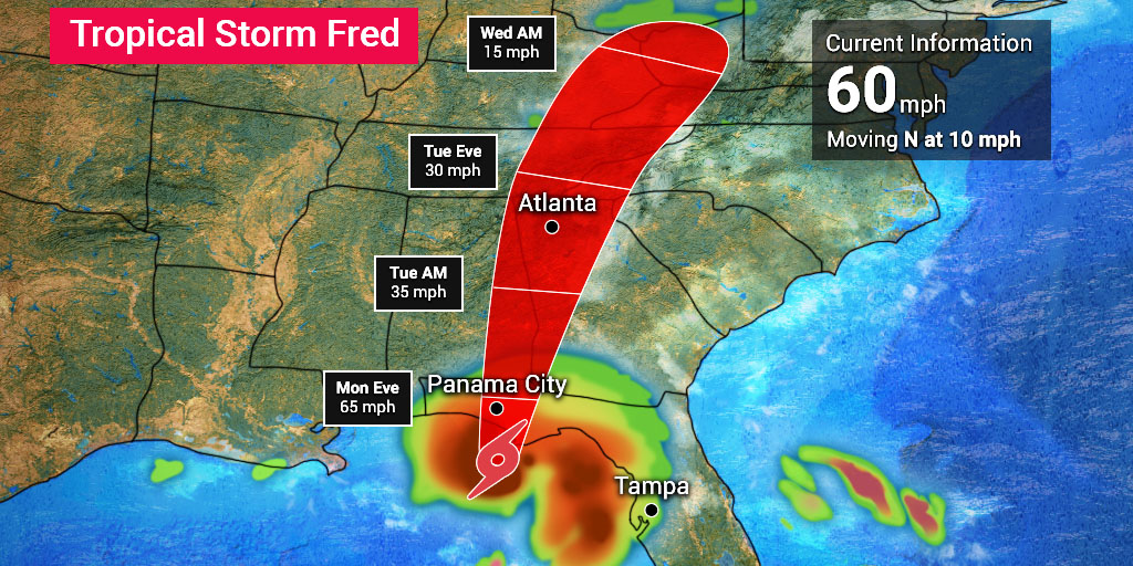
Tropical Storm Fred is bearing down on the Florida Panhandle as it nears hurricane strength. Fred lost some of its earlier intensity as it moved through the Caribbean and encountered land and increasing wind shear. However, the system regained its tropical storm status on Sunday morning as it continues to track toward the border of Alabama and Florida for an estimated Monday landfall.
Fred is currently moving to the northwest at a speed of 8 mph. Fred is expected to stay well off land for the rest of the weekend. However, the moisture in the outer bands will continue to impact Florida for the next few days. The majority of the rainfall and the threat of severe weather will remain to the east of Fred’s center.
On Sunday, Fred was staying with its predicted path moving into the warmer waters of the interior of the Gulf of Mexico. These favorable environmental conditions may help to give Fred a little boost prior to its landfall. The storm will move to the northwest for the remainder of the weekend. The system is predicted to take a turn to the north, putting the coastal areas near the border of Alabama and Florida in the crosshairs for landfall.
Forecasters with the National Hurricane Center (NHC) are warning residents of this region of the Gulf Coast to be on alert for rapidly changing weather over the next 48 hours. Strong surf conditions are expected as the storm moves closer to the Florida Panhandle.
Cities that need to be prepared for a potential landfall and its effects include Panama City, Pensacola, and Tallahassee, Florida.
As with most tropical events, winds are expected to be an issue as Fred makes its approach. The strongest wind gusts are forecast where the eyewall coms onto the shore. Widespread power outages are a risk throughout the Florida Panhandle and into Alabama.
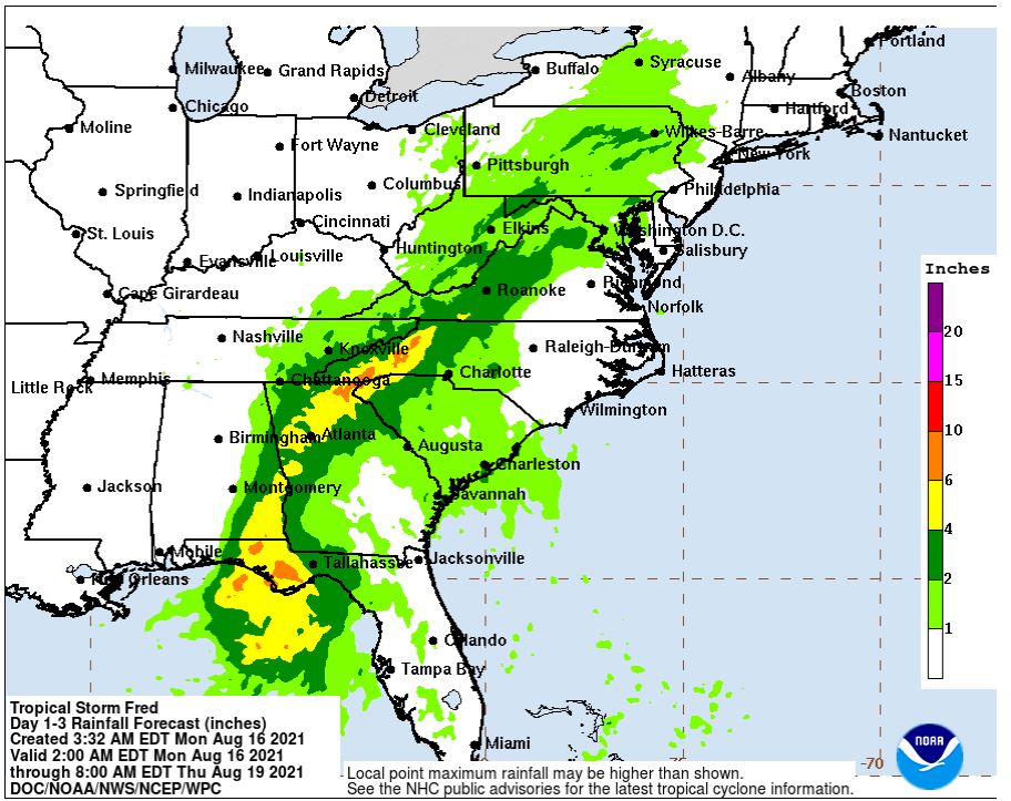
The highest rainfall amounts will likely be measured in the far western corner of the Panhandle and southern Alabama. Up to eight inches of rain may fall in some locations. The good news is that Fred’s relatively fast speed will prevent consistent rainfall that socks in a region.
Flash flood watches are currently in effect for the Florida Panhandle, southwestern Georgia, and southern Alabama.
Fred will bring a chance of heavy rainfall to the Southeast throughout the first part of the week. The storm’s bands will begin to turn to the northeast once it makes landfall, bringing its effect to the Tennessee Valley and the southern Appalachian region.
Tropical moisture will dump as far east as Mississippi. The remnants of Fred will be far-reaching with rain forecast in Georgia, the Carolinas, and as far north as West Virginia. Over four inches of rain may fall in western North Carolina, northern Georgia, and eastern Tennessee through Wednesday. This forecast puts cities such as Birmingham, Alabama at risk of flash flooding.
Coming in behind Tropical Storm Fred is Tropical Storm Grace. This developing system strengthened into a tropical storm on early Saturday morning. By early Sunday morning, the storm was moving to the west and northwest 16 mph as it spun about 60 miles east-southeast of the Caribbean island of St. Croix. Grace is packing sustained winds of 40 mph.
As of mid-day Monday, Grace has been downgraded to a tropical depression after reaching tropical storm status. According to the NHC, Grace is nearing the Barahona Peninsula of the Dominican Republic as it moves to the west at 15 mph.
The threat of tropical weather in Haiti is particularly worrisome as officials continue to grapple with a massive 7.2-magnitude that rocked the island nation on Saturday morning. At least 700 fatalities have been reported with authorities warning that the death toll will climb even higher in the coming days. The arrival of Grace will certainly hamper rescue and recovery efforts.
Most models predict that Grace will keep with its westward track over the next few days. This track is similar to Fred’s journey during its early days. However, current atmospheric winds will bring Grace on a different path as it continues to move through the Caribbean.
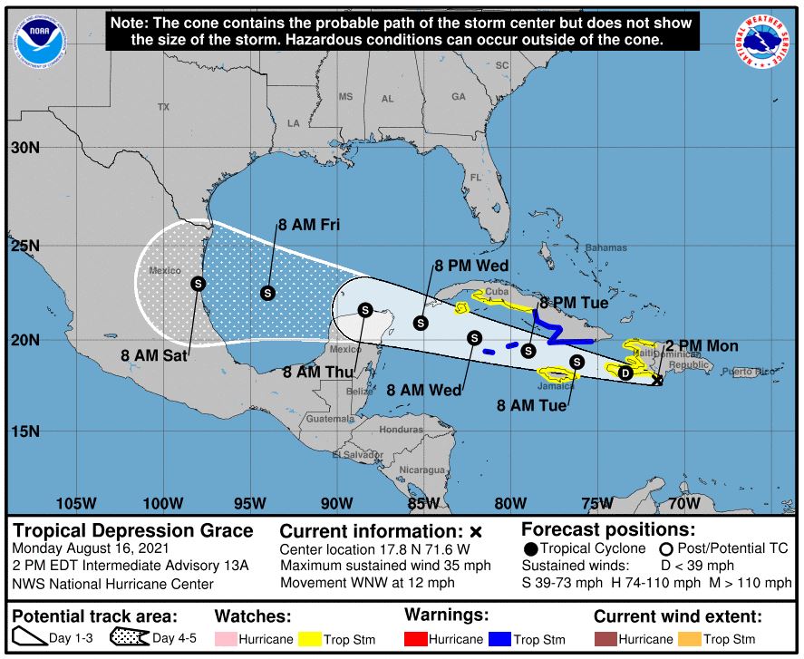
Wind shear and dry air will likely limit how much Grace can intensify and organize as it moves into the Gulf of Mexico. The current path shows Grace finally moving onto land near the southern portions of Texas next weekend. However, as anyone who follows tropical weather knows, this trajectory can change a number of times before then.

January 21, 2024

January 19, 2024

January 18, 2024
