
Heavy Rain, Flooding, and Chance of Severe Weather Staring Down the Southern U.S.
January 22, 2024
Posted: August 11, 2021 2:02 pm


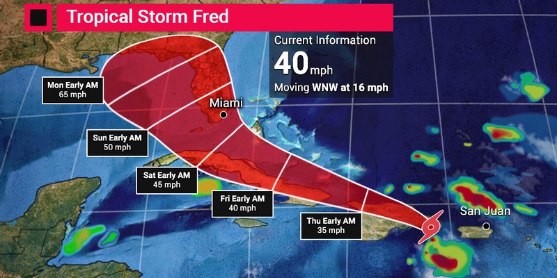
Tropical Storm Fred is here. The sixth-named storm of the 2021 Atlantic hurricane season officially formed on Tuesday night at about 11 pm local time just south of Puerto Rico. The storm is on course to potentially bring significant impacts to Florida and beyond.
As of late Wednesday morning, Fred was located just south of the eastern edge of the Dominican Republic, approximately 25 miles south-southeast of the capital city of Santo Domingo. The storm is moving to the west-northwest at 16 mph with maximum sustained winds of 45 mph. Tropical Storm Fred has seen an increase in wind speeds through the morning hours, indicating strengthening of the system.
Fred is predicted to stay on a west-northwest path for the next few days. This trajectory will take it over the islands located in the northern part of the Caribbean Sea through Wednesday and Thursday. On Friday, the storm is forecast to turn toward the northwest and north. This path would bring the storm on a crash course with Florida. The timing of the expected northward turn will determine if the storm makes a direct hit on Florida or if it moves farther to the west and strikes the Gulf Coast instead.
Although the tropical storm warnings have been discontinued for Puerto Rico, the storm has already taken out power in parts of the region. This island is vulnerable to outages after 2017’s Hurricane Maria uprooted the power grid. Officials in Puerto Rico have opened at least eight shelters to house storm evacuees.
A tropical storm warning is still in place for the majority of the coastline surrounding the Dominican Republic. In addition, a tropical storm watch is now in effect for the Turks and Caicos, parts of Haiti and Cuba, and the southeastern corner of the Bahamas.
The Dominican Republic will likely see the heaviest of the rains in the Caribbean with up to five inches predicted. This heavy rain will naturally raise the threat of flash flooding and mudslides.
Other parts of the Caribbean, including the Turks and Caicos, Haiti, and the eastern parts of the Bahamas and Cuba, may see up to three inches of rain by the time that Fred makes its exit.
Most forecasts are in agreement that Tropical Storm Fred is likely to weaken a bit late Wednesday and into Thursday. This will happen when the storm moves over the mountainous terrain of Hispaniola as it also encounters stronger wind shear to break it up.
By Friday, Fred will be moving closer to Cuba and the southeastern Bahamas. The warm waters of this part of the ocean may help it to reorganize and strengthen. However, Fred could also weaken again if it meets up with more wind shear or if its path takes it over Cuba instead of just its surrounding waters.
As of Wednesday, the National Hurricane Center (NHC) predicts that Fred will intensify when it reaches the warm waters near the Florida Keys. It is important to note that this forecast can change dramatically if steering winds take Fred in a different direction.
Even if Fred does not make a direct hit on Florida, its outer bands will likely bring rain and wind to the Sunshine State throughout the weekend. The rain and wind will not move out until early next week, delivering a soggy weekend for most of the state and into the Southeast or the Gulf Coast.

January 21, 2024

January 19, 2024

January 18, 2024
