
Heavy Rain, Flooding, and Chance of Severe Weather Staring Down the Southern U.S.
January 22, 2024
Posted: August 20, 2021 3:08 pm


Hurricane Grace Gearing Up to Strike Mexico a Second Time
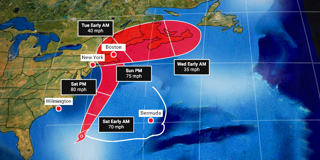
Tropical Storm Henri continues to look as if it is on a crash course with New England this weekend, potentially strengthening into a hurricane before it makes its landfall.
According to the National Hurricane Center (NHC), Henri is a strong tropical storm as of late Friday morning. The storm is packing maximum sustained winds of 65 mph with the tropical-storm-force winds extending out approximately 90 miles from its center. This compact storm is positioned about 340 miles south-southeast of Cape Hatteras, North Carolina, moving to the west and northwest at a speed of 7 mph.
Hurricane watchers are warning that this storm poses the greatest threat of tropical activity that the New England area has seen in 30 years. Earlier in the week, it had appeared as if the storm would move out to sea and not threaten the US. However, a trek to the west is putting New England in the crosshairs of the potential hurricane.
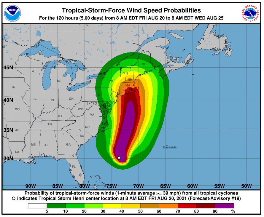
As of now, forecasters predict that the storm will make landfall as a hurricane in Rhode Island near Narragansett Bay. The storm will likely come ashore sometime on Sunday evening.
The NHC issued a slew of watches in anticipation of the storm. A hurricane watch is now in effect for the coastline reaching from the South Shore of Long Island, New York, up to Nantucket, Martha’s Vineyard, and Block Island, Massachusetts. In addition, a tropical storm watch is now in effect for some areas of New York City.
Heavy rain and flash flooding will be a concern as Henri inches near. Widespread tropical rainfall will be the story on Sunday in the area stretching from Long Island up into southern Maine. Up to eight inches of rain may drench vacationers trying to squeeze the last out of summer in Cape Cod and Martha’s Vineyard.
This rain will come just as the area starts to see relief from the effects of Tropical Rainstorm Fred. The already saturated ground may have a difficult time taking on even more moisture.
Henri will also bring wind gusts of 40 – 60 mph as it moves closer to land. The strongest wind gusts will sweep through southeastern New England with the most damaging gusts whipping around to the east of where the storm makes landfall. Gusts of up to 80 mph will be possible in this area on Sunday afternoon and evening. These winds could cause minor structural damage and downed power lines.
Henri will move into New England just as the full moon begins to rise on Sunday. This pairing could lead to higher tides in the region, raising the risk of coastal flooding. A storm surge of up to three feet is in the forecast from southern New Jersey up the coast of New England and into Nova Scotia through early next week.
A surge of 3 – 6 feet is expected for the area stretching from eastern Long Island to Boston. This could bring dangerous conditions for beachgoers in Cape Cod, Martha’s Vineyard, and Nantucket.
Elsewhere in the Atlantic basin, Grace is back to hurricane strength as it gears up for a second landfall in Mexico. The storm first made landfall on the eastern Yucatan Peninsula on Thursday as a Category 1 hurricane.
While Grace lost some of its strength while moving across land, it intensified once again on Friday morning as it moved back into the warm waters of the Bay of Campeche in the Gulf of Mexico. Forecasters expect that Grace will hold onto its hurricane strength as it closes in on another landfall predicted for late Friday or early Saturday.
There is also a chance that Grace could jump up to a Category 2 storm status prior to landfall. Hurricane warnings are currently in effect for a stretch of coastline expanding from Puerto Veracruz to Cabo Rojo. Landfall is expected near the town of Tecolutla.
Wind gusts of up to 90 mph are expected near the site of the landfall. Winds of this magnitude have the potential of causing widespread power outages along with structural damage. These winds will also lead to a storm surge of three to six feet, raising the risk of flash flooding.
Along with the damaging winds, rainfall amounts of 8 – 12 inches are predicted near the center of Grace. This heavy rain also raises the risk of mudslides in the mountainous terrain. The locations most likely to see these heavy rains include Central Veracruz, Hidalgo, Tlaxcala, and Puebla.
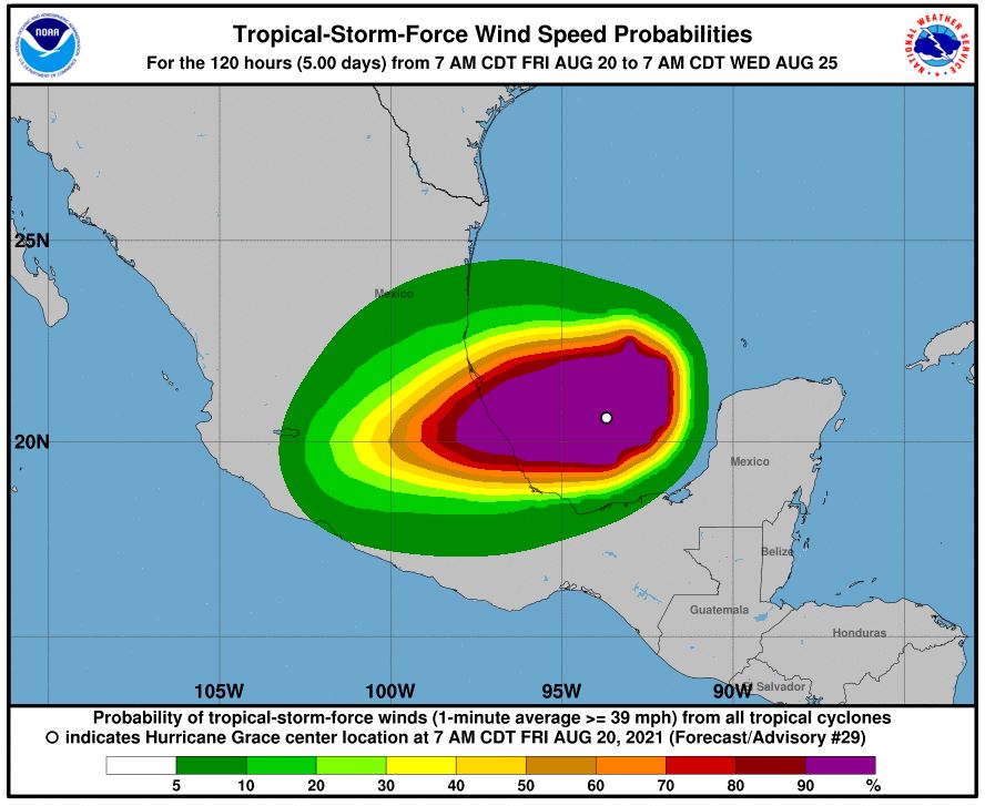
Grace will lose intensity as it moves to the west across Central Mexico. However, even areas as far inland as Mexico City may see rain of up to two inches by Saturday. Grace is forecast to become a tropical rainstorm by Sunday. The storm will probably still have enough steam to re-emerge in the eastern Pacific by the end of the weekend.
Once it reaches these warm waters, there is also the chance that it could reorganize once again. Should what is left of Grace develop into an organized tropical weather event, it would take on the name of Marty, the next name on the list of storms in the Pacific for 2021.

January 21, 2024

January 19, 2024

January 18, 2024
