Heavy Rain, Flooding, and Chance of Severe Weather Staring Down the Southern U.S.
January 22, 2024
Posted: August 27, 2021 11:10 am


Both Atlantic and Pacific Experience Significant Tropical Activity
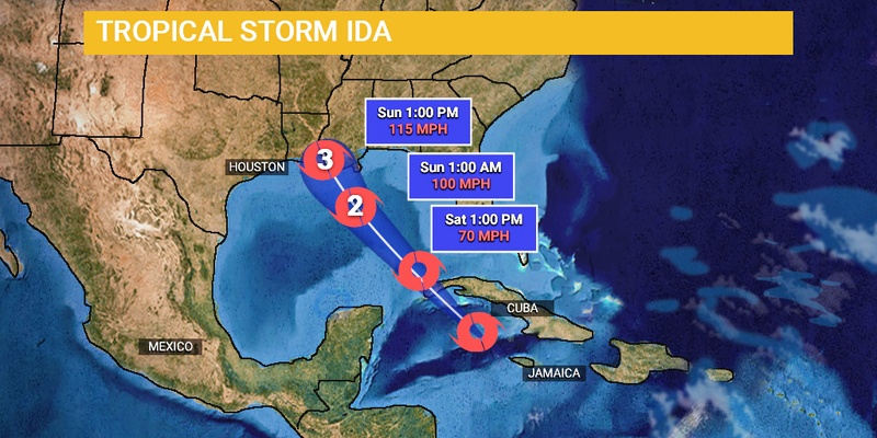
While just Wednesday it looked like the latest tropical feature in the Caribbean would move across Mexico, it now looks like the US Gulf Coast will be the one to take the direct hit. Tropical Storm Ida formed on Thursday afternoon, becoming the ninth named storm of the 2021 Atlantic hurricane season.
Forecasters at the National Hurricane Center (NHC) have been monitoring this tropical feature since early this week when it first emerged as a disorganized group of showers and thunderstorms in the southwest Caribbean. The feature quickly intensified into a tropical depression by mid-day Thursday. It was just hours later that Ida the tropical storm was born.
As of late Thursday, Ida was traveling at a speed of 13 mph in a northwesterly direction. Ida is quickly approaching the islands of Jamaica and Grand Cayman Island. The storm will skirt over the Caribbean over the next day or two before moving out into the open waters of the Gulf of Mexico where more intensification is in the forecast.
During the initial model runs, the storm was not forecast to impact the US. However, the area of high pressure that is positioned near the coast of the Carolinas is expected to weaken in the coming days, steering the storm more to the northwest and closer to the US. The circulation that is left around this high should be enough to push the storm along through the Caribbean Sea and into the Gulf of Mexico. This trajectory is leading the storm toward the western and central Gulf Coast as opposed to the first forecast of landfall in southern Mexico.
It is still too early to predict what exact path Ida will take once it reaches the Gulf of Mexico. Forecasters are cautioning residents along the Gulf coast stretching from Texas through Louisiana, Mississippi, Alabama, and into the Florida Panhandle to be monitoring the storm over the weekend. Current models show a landfall along the Gulf Coast late Sunday or early Monday.
The first bands of rain could move into the central Gulf Coast by late Saturday night or early Sunday. Ahead of the rain, rough seas will begin to affect the coastal areas of this region.
Warmer than average sea surface temperatures in the Gulf of Mexico will be conducive for further strengthening in the coming days. Forecasters warn that the storm could strengthen into a major hurricane of Category 3 or higher if it encounters the right conditions.
If Ida maintains its current steady speed, it is forecast to drop between four to eight inches of rain closest to the center of the storm as it moves onshore. However, if the speed slows down, the rainfall amounts will likely be much higher.
While there have been five named storms that have made landfall in the US this year, none of these have arrived as hurricanes. Danny, Elsa, Fred, Claudette, and Henri have all stormed through the US this year as tropical storms. Will Ida be the first?
Ida is not the only system that forecasters are watching in the Atlantic. An area of low pressure is spinning over the central Atlantic about 650 miles east of Bermuda. This area is delivering disorganized rain showers and thunderstorms. The upcoming forecast shows environmental conditions friendly to intensification, making forecasters almost certain that a tropical depression will form over the weekend. The feature is predicted to move to the east over the next few days with a turn to the northeast forecast for Sunday.
Additionally, a tropical wave is positioned about halfway between the Cabo Verde Islands and the Lesser Antilles. This wave is pumping out rain and thunderstorms with more development and organization expected over the next several days. This disturbance is expected to also form into a tropical depression sometime this weekend. However, it is forecast to meet stronger wind shear and cooler waters after this, potentially causing it to weaken.
Over in the Pacific Ocean, Tropical Storm Nora has the potential of strengthening into a hurricane in the next day or two. Tropical Storm Nora is currently located several hundred miles to the southwest of Mexico in the eastern Pacific. However, it is forecast to potentially near the Baja Peninsula of Mexico by late Sunday or early Monday, bringing heavy rainfall throughout the weekend.
Even if Nora does not make direct landfall on the Baja Peninsula, the region will begin to see the impacts of the rain and winds by the weekend. Most models predict that Nora will become a hurricane by early Saturday.
The heaviest rainfall is forecast for western Michoacan, Colima, and Jalisco beginning late Friday and continuing through Saturday. The greatest risk of damaging wind gusts will be in central Jalisco.

January 21, 2024

January 19, 2024

January 18, 2024