
Heavy Rain, Flooding, and Chance of Severe Weather Staring Down the Southern U.S.
January 22, 2024
Posted: October 8, 2022 9:41 am


There is a new named storm in the Atlantic basin, proving that the 2022 season is far from over. Tropical Storm Julia formed near the coast of Columbia on Friday, taking aim at Central America in the coming days. Here is what you need to know about the latest threat in the tropics.
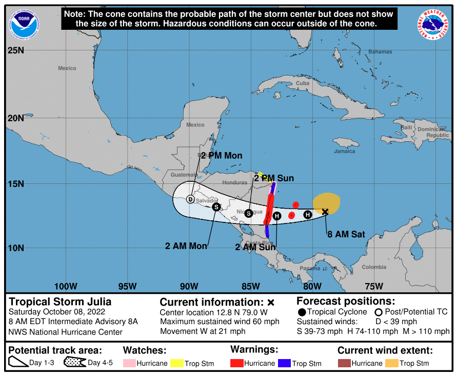
Forecasters with the National Hurricane Center (NHC) have had their eyes on this disturbance for over a week. The system was categorized on Tuesday as a tropical rainstorm, becoming a tropical depression on Thursday night. The feature had picked enough characteristics to be labeled a tropical storm by the middle of Friday.
As of late Friday, Julia was moving to the west at a speed of 18 mph. The storm was packing maximum sustained winds of 40 mph, positioned about 400 miles east of Isla de Providencia, Colombia, and approximately 140 miles north-northeast of Barranquilla, Colombia.
The NHC is warning that Julia will likely strengthen into a hurricane over the weekend. As such, hurricane watches and warnings have been issued for the islands located off the coast of Columbia as well as some portions of the Nicaraguan coastline.
The storm has already brought heavy rain and flooding to the Windward Islands, including Tobago and Trinidad. This torrential rain eventually made its way to the northern coast of Venezuela and across the ABC Islands.
![[Image of probabilities of 34-kt winds]](https://www.nhc.noaa.gov/storm_graphics/AT13/refresh/AL132022_wind_probs_34_F120+png/115150.png)
While its proximity to South America mitigated its ability to organize and intensify over the last few days, the feature is now moving into the warmer waters of the southwestern Caribbean. This placement will make it more likely that it will find the conditions that it needs to develop into a hurricane.
The current models show the storm making landfall somewhere along the central coast of Nicaragua. The area can expect wind speeds to pick up and sea conditions to worsen on Saturday with the storm making a landfall on Sunday morning.
Even if the storm only strengthens into a Category 1 hurricane, Julia will bring wind gusts of up to 80 mph. This power is enough to knock out power and cause minor property damage. The rough seas will be a detriment to fishing and shipping interests in the region. There is also the chance of life-threatening storm surge to the north of where the storm comes on shore.
Forecasters are calling for 8 – 12 inches of rain throughout central and western Nicaragua and into the southern tier of Honduras. Eastern El Salvador may also see substantial moisture out of this developing system. Rain in these amounts will undoubtedly trigger flooding and a high risk of mudslides over the higher terrains.
The torrential rain, flooding risk, and strong winds will eventually move to the west and north into southern Mexico by the end of the weekend and into early next week. If the eye of the storm stays together as it moves across Central America, it could grow again in the southwestern Gulf of Mexico or the eastern Pacific. It would only change names if the eye dissipates before forming again.
There is also the chance that Julia could completely break up by the beginning of next week. Be sure to keep an eye on this tropical feature if you live in the potential impact zone.
Heading into next week, the NHC will be closely monitoring the southern Gulf of Mexico and the central Caribbean Sea for the potential of new tropical threats. A new front is expected to move into this area of the Atlantic Ocean. While the position of this front could create wind shear, it also may trigger the spin that contributes to tropical development.
The north-central Atlantic Ocean will also be under the microscope for new developments in the coming weeks. Although the 2022 Atlantic season is nearing its meteorological end, the conditions are still ripe for more tropical development.
Did you find this content useful? Feel free to bookmark or to post to your timeline for reference later.

January 21, 2024

January 19, 2024

January 18, 2024
