
Heavy Rain, Flooding, and Chance of Severe Weather Staring Down the Southern U.S.
January 22, 2024
Posted: September 7, 2023 1:02 pm


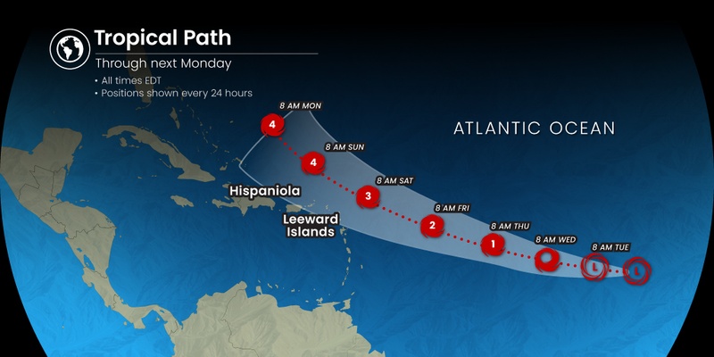
Tropical Storm Lee formed in the Atlantic basin on Tuesday with forecasters predicting that it is likely to become a major hurricane by this weekend. Here is what you need to know about this potentially dangerous storm.
The northeastern Caribbean is bracing for a major hurricane to churn through its waters in the coming days. Tuesday was a busy day in this part of the Atlantic. The National Hurricane Center (NHC) designated a disturbance as Tropical Depression 13 during the morning hours. By 5 pm EDT, this depression had strengthened into a tropical storm.
Lee is forecast to move through the basin throughout the week, gradually transforming into a hurricane. The storm will be able to strengthen quickly thanks to a number of supportive environmental conditions. A lack of dry air, low amounts of vertical wind shear, and exceptionally warm sea surface temperatures will all work together to support this development into the weekend.
The only factor that looks to potentially stymie the intensification of this feature will be the presence of sinking air. The downward motion of these sinking air masses would mitigate the formation of clouds within the system. At this point in the forecast, the experts are predicting that some areas of sinking air present in the Atlantic could slow down the growth of this storm in the early days.
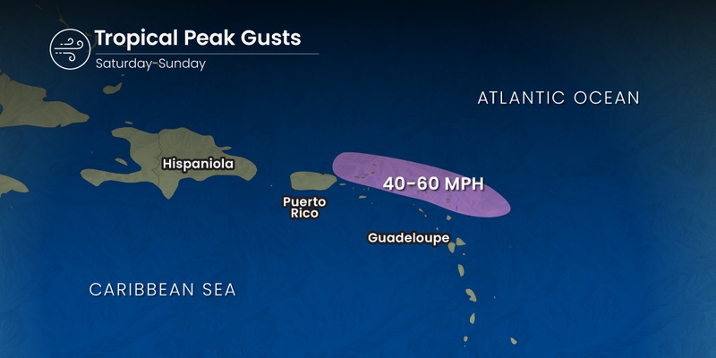
The big question at this point is where is Lee headed? The current models show that Lee is going to continue to move in a westerly direction into the weekend. This track will take it into the eastern Caribbean and just to the north of Puerto Rico and the northern tier of the Leeward islands. Islands that could see some of the impacts of Lee include Anguilla, Antigua, the British Virgin Islands, and Barbuda.
The outer bands of Lee are expected to deliver rainfall amounts of 1 – 2 inches for the northern Leeward Islands over the weekend. Tropical gusts could hit up to 60 mph during this time.
The steering winds over this part of the Caribbean could take Lee to the northeast of the Bahamas as it slows down its speed. It will then likely move into a portion of the Atlantic that is seeing slightly cooler ocean waters due to the recent tropical activity. However, forecasters are warning that these temperatures could increase by the time that Lee arrives, setting the stage for a greater chance of intensification by early next week.
These same steering winds will influence if Lee impacts the U.S. next week. It is too far out in the forecasting models to predict with certainty if the U.S. will take a direct strike or if the storm will stay far from the coast.
Regardless of Lee’s eventual path, there is a good chance that the beaches up and down the East Coast will feel the impacts in the form of dangerous surf conditions and rip currents. The anticipated impacts to the U.S. and up into Atlantic Canada will fall between September 13 and 16. This is right in line with the statistical peak of the Atlantic hurricane season, falling on September 10.
September is typically a busy time for tropical weather development in the Atlantic. Past September storms include hurricanes Maria, Ike, Isabel, Irma, and Rita. Hurricane Irma is distinguished as the first Category 5 storm to hit the Leeward Islands. And nobody will soon forget last year’s Hurricane Ian that proved to be deadly in Southwest Florida.
The name Lee has also been associated with a number of potent tropical events. While it remained at sea, Hurricane Lee reached the status of a Category 3 storm in 2017. In 2011, Tropical Storm Lee came onshore in Louisiana before moving up into the mid-Atlantic and the Northeast, triggering mass flooding throughout the region.
Did you find this content useful? Feel free to bookmark or to post to your timeline for reference later.

January 21, 2024

January 19, 2024

January 18, 2024
