
Heavy Rain, Flooding, and Chance of Severe Weather Staring Down the Southern U.S.
January 22, 2024
Posted: October 31, 2022 2:49 pm


There is a new menace in the western Caribbean thanks to the recent formation of Tropical Storm Lisa. This storm officially formed on Monday with parts of Central America in its path. Here is the latest on the tropics as the calendar flips to the last month of the official 2022 Atlantic hurricane season.
As of late Monday morning, Tropical Storm Lisa was churning approximately 175 miles south of Kingston, Jamaica. This location also put it about 365 miles southwest of Grand Cayman Island. The system was moving at a speed of 14 mph in a westward direction with maximum sustained winds of 40 mph, just over the threshold for a tropical storm. A tropical storm watch has been issued for the island of Jamaica.
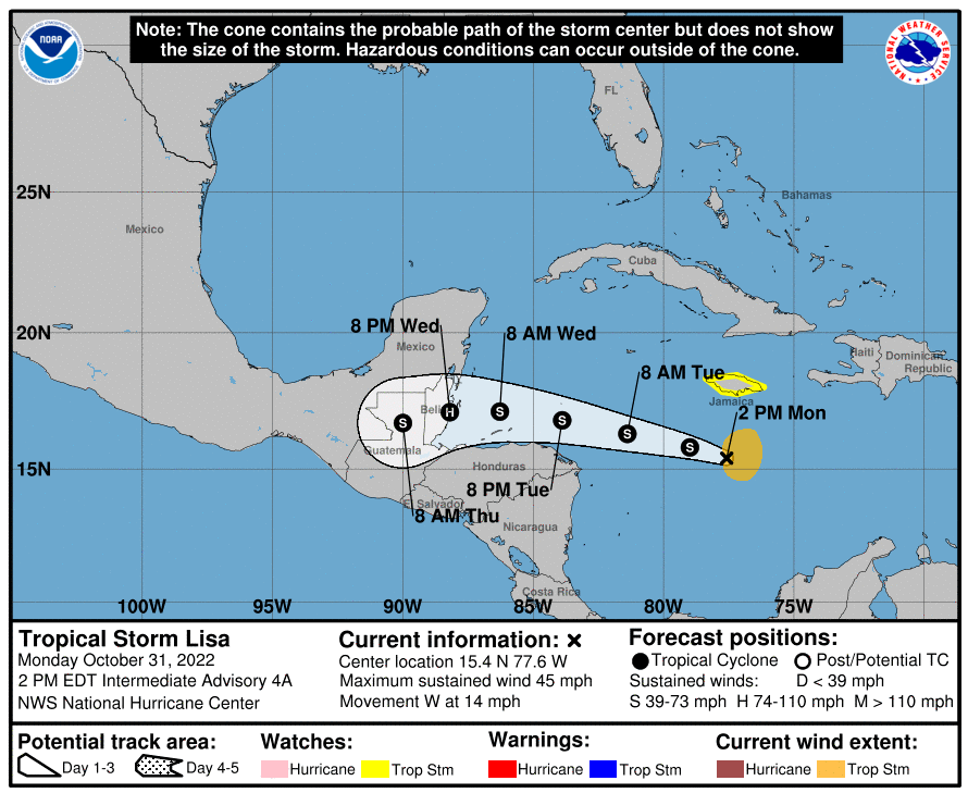
This storm did not come out of nowhere. Experts with the National Hurricane Center (NHC) had been warning for the last few weeks that a system could take root in this part of the Caribbean during this timeframe. The NHC officially designated the rapidly organizing system as a potential tropical cyclone on Sunday evening when it became clear that this feature was not going to dissipate.
According to meteorologists, the worst of the thunderstorms associated with this system will be located to the east of the storm’s center. The odds of it becoming a hurricane will be lower if it takes longer to organize and intensify over the coming hours.
The latest models show the storm making landfall in Belize on Wednesday night. This part of Central America will begin to feel impacts in the shorter term as the winds and rough seas approach the coast.
There is also the chance that the storm could move in a straighter line to the west rather than the northwest. Should this happen, it would be Honduras that is in the primary impact zone. However, this track would also make it less likely that the system develops into a hurricane.
Although this particular feature is smaller in size than some of the typical storms that have come out of this region, it could ramp up quickly if it finds the right environmental conditions. Keep in mind that this part of the Caribbean still offers exceptionally warm ocean waters to trigger rapid intensification. In addition to water temperatures in the 80s, the northwestern Caribbean is also expected to see lower amounts of wind shear. Together, these factors could trigger rapid intensification.
The storm is predicted to deliver heavy rainfall to parts of Central America by the middle of the week. A general 4 – 8 inches of rain will drop along the storm’s direct path. As much as 12 inches may fall in more localized areas.
Rainfall of this magnitude will almost certainly lead to urban flooding as streams and rivers rise rapidly. Mudslides are another serious concern in the hillsides of Central America. Inland areas of Guatemala and Honduras will be subject to some of the most dangerous impacts of this tropical feature.
Depending on its intensification over the next few days, winds may approach up to 90 mph. These winds may reach as far as 100 miles from the center of the storm, potentially bringing down trees and power lines.
Heading into the end of the week, Lisa is predicted to devolve into a tropical depression or rainstorm by Thursday or Friday. Like two previous systems this year, there is a chance that Lisa could survive the journey across the southern tier of Mexico or Guatemala and emerge into the eastern Pacific. There has never been a year in recorded history when three different storms were strong enough to retain their name as they moved across land from the Atlantic into the Pacific.
It was Tropical Storm Bonnie that survived the trip in early July, lasting for over 6,600 miles and eventually becoming a major hurricane when it reached the Pacific. Hurricane Julia also made it clear across Central America keeping its name before spending a few hours in the eastern Pacific as a tropical storm.
Looking ahead, forecasters continue to predict that the southwestern Atlantic Ocean and the Caribbean are still boasting the conditions that can provide the impetus for tropical activity heading into November. This includes an area within a few hundred miles of the coast of Florida. The most likely time for development in this corner of the Atlantic would be during the second week of November.
The Atlantic hurricane season will come to its calendar end on November 30.
Did you find this content useful? Feel free to bookmark or to post to your timeline for reference later.

January 21, 2024

January 19, 2024

January 18, 2024
