
Heavy Rain, Flooding, and Chance of Severe Weather Staring Down the Southern U.S.
January 22, 2024
Posted: November 8, 2022 2:51 pm


The storm system moving through the Caribbean on a crash course with Florida has now strengthened into a tropical storm, putting much of the East Coast on alert. Here is the latest on this quickly developing storm and what you can expect in the coming days.
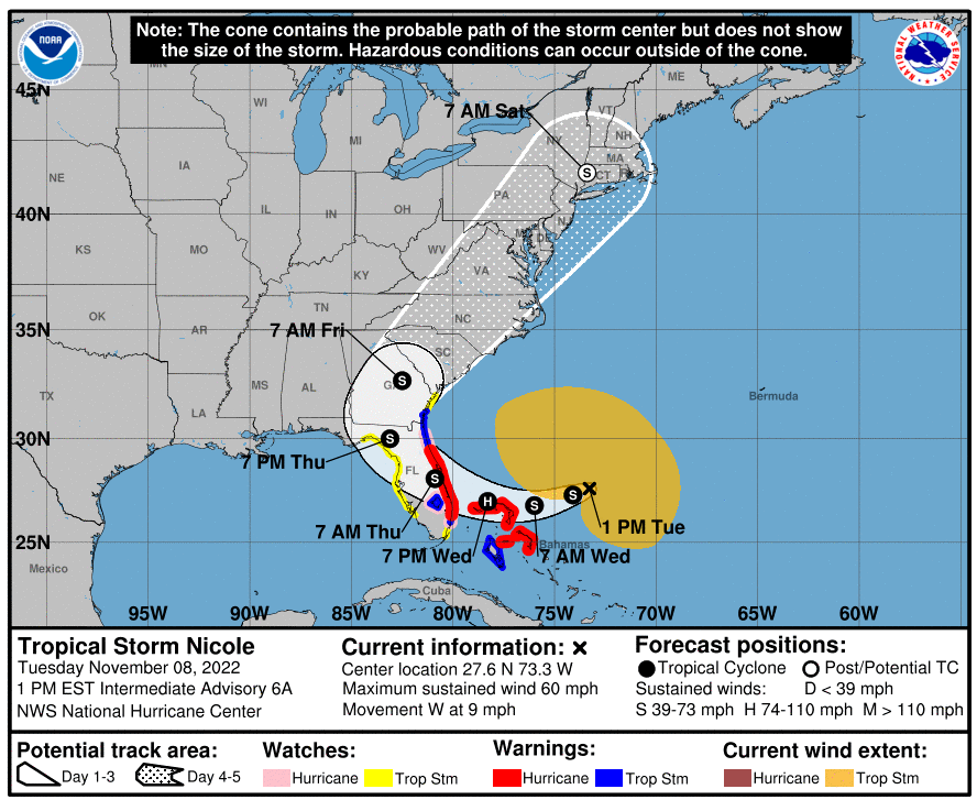
Nicole has officially transitioned from a subtropical system into a tropical storm. Nicole is packing sustained winds of 50 mph as it moves to the west at a speed of 9 mph. As of the middle of the day Tuesday, Nicole was located about 450 miles east of West Palm Beach, Florida.
Hurricane warnings are now in effect along the central portions of Florida’s east coast as the storm continues to show signs that it will strengthen in the hours to come. The large storm is forecast to gain enough intensity to hit the eastern coast of Florida as a likely Category 1 hurricane before taking a journey up the Atlantic Seaboard.
A hurricane warning is also in effect for the northwestern Bahamas. In addition, an area stretching from the northeastern Florida coast up through parts of Georgia are under a tropical storm warning.
Florida Gov. Ron DeSantis moved to declare a state of emergency for the Sunshine State in advance of the storm’s landfall. Nicole is predicted to make landfall sometime late Wednesday or early Thursday.
The timing of the full moon will likely heighten the impacts of Nicole as it pounds the coast of Florida. The storm is predicted to come in at a perpendicular angle right through the heart of the peninsula. The effects of a full moon and the easterly winds coming in from the Atlantic Ocean will serve to increase the risks associated with this storm. The greatest area of impact is expected to be in a stretch of coastline from West Palm Beach up through St. Augustine.
Because of the full moon, the tides will be above normal on Wednesday and into Thursday. This translates to a water level rise measured in feet as Nicole moves inland. Storm surge between 3 – 6 feet is in forecast from West Palm Beach northward to Savannah, Georgia. The Space Coast of Florida up through Daytona Beach may see storm surge in excess of 6 feet.
Nicole will also bring tropical-storm-force winds for up to 48 hours. This is longer than most tropical systems hang around, increasing the risk that the storm will bring a higher chance of coastal erosion.
Complicating the issue is that many of the beaches in Florida were destroyed as a result of Hurricane Ian. This means that they will be particularly vulnerable to Nicole’s impacts.
Forecasters caution that there is still a chance that the center of Nicole could move farther to the north or south. This would bring greater impacts to populated areas such as Fort Lauderdale, Miami, or Jacksonville, depending on the exact location of landfall.
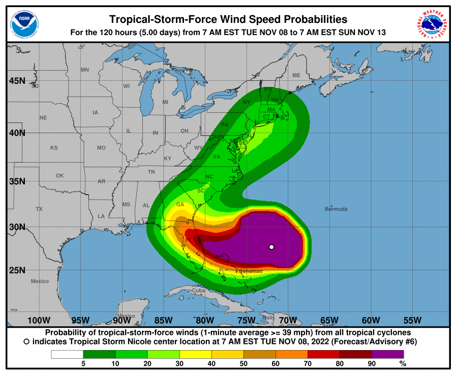
The sustained tropical-storm-force winds of at least 40 mph or greater are predicted to hit the eastern coast of Florida by Wednesday night. The region may experience sporadic gusts of this intensity beginning late Tuesday. This is because the storm is large in size, making the winds extend over a bigger area than is typical.
In fact, forecasters are predicting that the tropical-storm-force winds may extend to almost three-quarters of a million square miles, speaking to the great impact of this large storm. For example, the gusty winds and rough seas will stretch from southeast of Bermuda, into the Bahamas, and toward the southeastern corner of the U.S. There is even the possibility that these impacts will be felt in the eastern Gulf of Mexico as the system moves to the west through Florida before making another turn to the north.
The highest wind gusts are expected to peak at about 60 to 80 mph across the eastern coast of Florida. The good news is that the hurricane-force-winds will churn up in a much more compact area.
The southern and central portions of Florida will also be at risk for isolated tornadoes and waterspouts as Nicole churns up the atmosphere.
Nicole is predicted to stay on a westward trajectory after making landfall. This will put much of the peninsula under the gun for the impacts, including the areas that were hit hard by Hurricane Ian in late September. Nicole will then take a turn to the northeast later in the week.
There is a slight chance that the westward path will continue long enough to bring Nicole out into the Gulf of Mexico near Tampa. Should this happen, the storm would find environmental conditions that favor further strengthening. However, the storm will begin to weaken as it makes its turn up the Eastern Seaboard if the center does not move into the Gulf.
Florida will feel the greatest impacts on Thursday and Friday. A general 4 – 8 inches of rain will drop near the center of the storm. This will likely trigger flooding concerns. Cities such as Orlando and Tampa will see the worst impacts through Thursday night.
After exiting Florida, Nicole is predicted to move parallel to the East Coast until it reaches Atlantic Canada this weekend. This will bring the impacts to millions of people in its path.
The impacts will be lesser if Nicole stays a bit farther from the coast as it runs parallel. A number of unrelated atmospheric conditions will influence this path. For example, a dip in the jet stream will be the driving force behind the path of the storm and whether it not its worst impacts stay out to sea.
While it is still too early to predict with accuracy, it is likely that there will be meaningful impacts along the coastlines of Georgia, the Carolinas, and southeastern Virginia.
It is not typical for tropical features to affect the east coast of Florida this late in the season. Nicole is the 14th named storm of the 2022 Atlantic hurricane season, set to officially end on November 30.
Did you find this content useful? Feel free to bookmark or to post to your timeline for reference later.

January 21, 2024

January 19, 2024

January 18, 2024
