
Heavy Rain, Flooding, and Chance of Severe Weather Staring Down the Southern U.S.
January 22, 2024
Posted: September 17, 2022 10:02 am


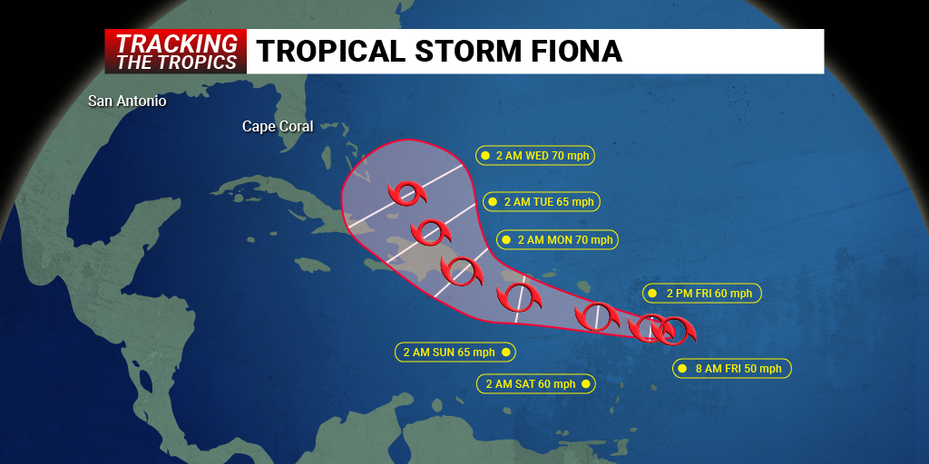
Tropical storm warnings were issued for the U.S. Virgin Islands and Puerto Rico on Friday ahead of the anticipated wrath of Tropical Storm Fiona. Here is the latest on this developing storm and what impacts the U.S. may see in the coming days.
As of late Friday, Tropical Storm Fiona had moved past the Leeward Islands as it tracked deeper into the heart of the Caribbean Sea. The storm system was packing winds of at least 60 mph with the wind stretching outward up to 140 miles, an increase from the 125-mile range reported earlier in the day.
Fiona is chugging along at 14 mph in a westward direction. In addition to the current tropical storm warnings, the British Virgin Island and Dominica remain under a tropical storm watch.
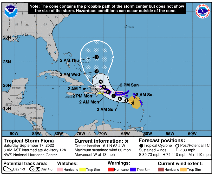
Puerto Rico will be under the gun for Fiona’s impacts over the weekend as the storm moves to the west. By late Sunday, forecasters are predicting that Fiona will turn directions and move to the north. This path will take it over Hispaniola, delivering heavy rain and damaging winds to the Dominican Republic and Haiti.
![[Image of probabilities of 34-kt winds]](https://www.nhc.noaa.gov/storm_graphics/AT07/refresh/AL072022_wind_probs_34_F120+png/145703.png)
With Puerto Rico boasting mountains rising 4,000 feet and Hispaniola’s mountains towering up to 10,000 feet, the storm is predicted to weaken for a bit as it crosses over this terrain. The high mountains tend to drag down storm systems while bringing dry air into the fold, reducing the intensity and size.
However, winds are still expected to stay at a tropical storm designation, ranging between 40 and 60 mph. This means that some of the most vulnerable areas of these islands can expect to see power outages and some level of damage.
The storm is also packing a significant amount of moisture. Because of the slow-moving nature of this particular system, some parts of western Puerto Rico and the eastern half of the Dominican Republic may see 8 – 12 inches of rain.
There is also the chance that Fiona could pick up in intensity early next week if the mountainous terrain does not completely break up the storm. Once it crosses over Hispaniola, the system will move into an area of the ocean with warmer waters and lower amounts of wind shear. These favorable conditions would support further development as the storm moves to the north and northwest toward the Bahamas.
The position of the jet stream will dictate where Fiona journeys by next week. If the jet stream dips to the south, this movement could send Fiona over the western and northern portions of the Atlantic.
A second potential scenario has the dip in the jet stream not hanging on long enough to push Fiona out to sea. Should this happen, Fiona may be able to crawl closer to the Eastern Seaboard by the end of the next week. Forecasters will continue to monitor the influencing weather patterns to discern where Fiona is likely headed in the coming days.
As of now, the National Hurricane Center (NHC) is predicting that the storm will gradually intensify into a Category 1 hurricane as it moves closer to the U.S. Be sure to stay tuned to the latest projections over the weekend as its track becomes clearer.
Did you find this content useful? Feel free to bookmark or to post to your timeline for reference later.

January 21, 2024

January 19, 2024

January 18, 2024
