
Heavy Rain, Flooding, and Chance of Severe Weather Staring Down the Southern U.S.
January 22, 2024
Posted: June 28, 2022 3:11 pm


Despite the presence of numerous road blocks in its path, a mass of showers and thunderstorms has formed into a tropical rainstorm with the chances of it gaining even more intensity growing by the day. Will the Atlantic basin see a named feature as the calendar transitions into July?
Tropical Rainstorm Moving Into More Favorable Conditions for Strengthening
This tropical feature initially did not look like it would survive the journey across the Atlantic Ocean last week. In addition to facing dry and dusty air, the feature also encountered a good amount of wind shear to try to break it up. However, the feature has now moved into waters that are more conducive to tropical development. Less wind shear and unseasonably warm ocean water are forecast to fuel the organization of this storm in the coming days.
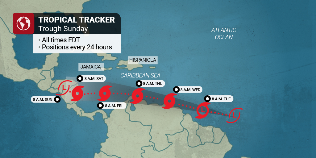
The system is predicted to move into the southern Windward Islands and Trinidad and Tobago by late Tuesday. There is a chance that the rainstorm could emerge as a tropical storm by Tuesday night or Wednesday morning. Should the system reach maximum sustained winds of 39-73 mph, the feature would take the name of Bonnie. The next name on the list is Colin.
Predicted Weather Impacts of This Feature
Even if the feature does not organize into a named storm, it will still deliver an increased risk of tropical downpours, high winds, and rough surf conditions by the middle of the week to the islands in its path. For instance, forecast rainfall amounts in the southern Windward Islands and through the northern coastal areas of South America is forecast to land around 2 – 4 inches.
In addition, wind gusts of 40 – 60 mph are in the forecast. Although the heavy rain may trigger isolated flooding, the impacts are not predicted to be severe in nature.
Forecasters are predicting that the system will move to the west at a speed of about 15 – 20 mph over the next few days. How quickly it intensifies and to what degree largely depends on how it interacts with the continent of South America. For example, it could weaken if it encounters too much friction from the landmass in its path.
Regardless of how this system develops, it is uncommon for this part of the Atlantic basin to see this type of tropical feature so early in the hurricane season. Developments this far to the south typically do not take root until September or October.
If the system stays on its current path, it is predicted to near Central America by Friday or Saturday. This could bring significant impacts to the eastern edges of these countries. Over 25 inches of rain could fall in the higher elevations of this region if the system does not dissipate. About six inches of rain could fall across a large area, triggering the possibility of numerous mudslides, flash flooding, and travel disruption.
The countries most likely to see these disruptions include Nicaragua and Honduras. This region may also see impacts from the strong winds that come on shore with this system.
![[Image of probabilities of 34-kt winds]](https://www.nhc.noaa.gov/storm_graphics/AT02/refresh/AL022022_wind_probs_34_F120+png/174453.png)
Experts at the National Hurricane Center (NHC) are continuing to monitor additional tropical waves that have been coming off the coast of Africa. One wave in particular has been flagged as having a slight chance to evolve into a tropical system by the end of the week or next week. The presence of these waves will almost certainly increase the regularity of tropical downpours in the Caribbean for at least the next week.
Although it has been quiet in the tropics over the last few weeks, we are at the time of the year when anything can develop, making it important that you keep a close eye on the forecast if you live in this region or have travel plans to the area.
Did you find this content useful? Feel free to bookmark or to post to your timeline for reference later!

January 21, 2024

January 19, 2024

January 18, 2024
