
Heavy Rain, Flooding, and Chance of Severe Weather Staring Down the Southern U.S.
January 22, 2024
Posted: April 4, 2023 9:30 am


Over a dozen states in the central U.S. will once again be dealing with severe storms. Forecasters are warning of a high risk of severe weather to strike on Tuesday, just days after the same part of the country experienced a rash of deadly tornadoes. Is your community in the line of fire? Read on for all of the details.
States at risk of seeing heavy rain, large hail, destructive winds, and tornadoes include Arkansas, Iowa, Indiana, Kansas, Illinois, Missouri, Texas, Oklahoma, Mississippi, Louisiana, Tennessee, Kentucky, Nebraska, Michigan, Wisconsin, and Nebraska. Like last Friday’s outbreak, Tuesday’s severe weather will be the result of the merger of an area of low pressure positioned over the Upper Midwest with a mass of warm and moisture-rich air filtering up from the Gulf of Mexico.
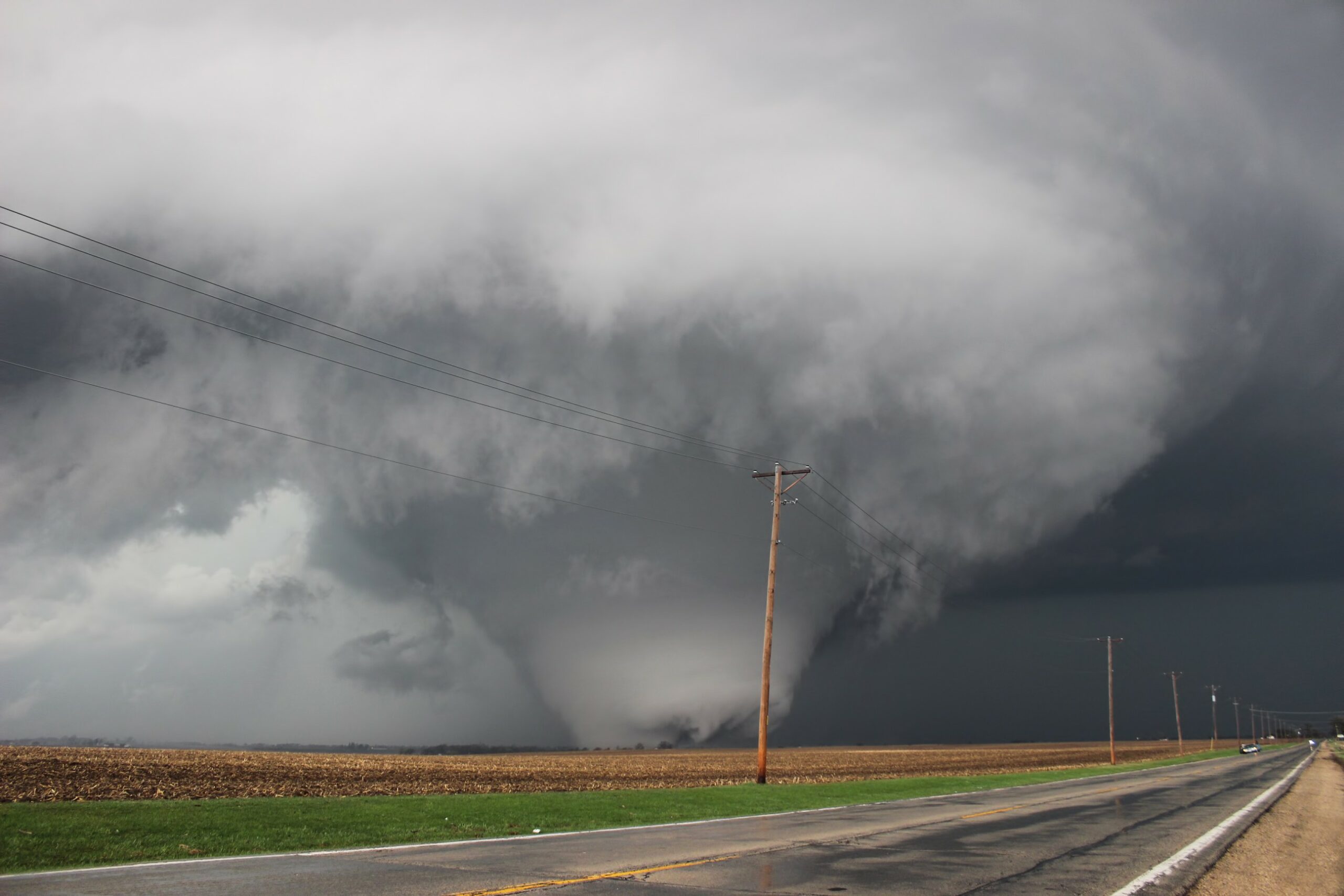
The National Weather Service (NWS) is still working to confirm the dozens of preliminary tornado reports from Friday and Saturday. By Monday, the agency had confirmed 66 of these reports as tornadoes. In addition to at least nine EF3 tornadoes packing winds between 136 and 165 mph, there was at least one EF4 twister in the southeastern corner of Iowa.
Saturday’s outbreak had not even dissipated before forecasters were warning of a new risk popping up on Tuesday. This threat level was raised on Monday morning, indicating a higher confidence in the likelihood of a major outbreak in the coming hours.
According to the NWS Storm Prediction Center (SPC), almost 50 million Americans are in the potential impact zone for Tuesday’s storms. By the time the line of storms pushes to the east on Wednesday, the number of impacted Americans could exceed 100 million.
Unfortunately for those people in this part of the country, the highest risk will come after dark Tuesday and into the pre-dawn hours Wednesday. Nocturnal twisters are typically more dangerous because they occur when many people are sleeping and unaware of the developing weather.
Like most thunderstorm development, the morning hours will likely begin calm and tranquil. The normal heating of the day will spur the development of severe weather in the afternoon and evening.
Weather experts are also warning that Tuesday’s conditions will provide a fertile ground for the breeding of strong tornadoes. Because these twisters will have the capability of moving at speeds of over 40 mph, there will be less warning time for those in their path. This is why it is vital to enable all weather alerts on your smartphone if you live in the potential zone of impact.
Tornadoes will not be the only weather threat for Tuesday and Wednesday. Straight-line high winds will come up from the storm cells, hitting gusts of up to 80 mph. Large hail could also be an issue.
The threat of the severe weather will push to the east on Wednesday, bringing the impacts to the eastern half of the Ohio Valley and the eastern Great Lakes. This risk may move as far east and south as the central Appalachians.
The South will also also be under the gun for locally severe storms. This includes the upper coast of Texas, across to southern Louisiana, and up into northern Kentucky. While this activity is not as likely to produce tornadoes, large hail and strong winds could be a major issue for the Gulf Coast up into the Tennessee Valley.
You should expect travel disruptions if traveling by air on Tuesday and Wednesday. Cities that may be impacted by potential ground stops include Chicago, St. Louis, Kansas City, Milwaukee, Cincinnati, Memphis, Little Rock, and Des Moines.
The storms will continue to move toward the Atlantic coastline on Thursday. While these storms are not expected to be severe in nature, they could bring heavy rain for a large area stretching from southern New Jersey, through the mid-Atlantic, and down into Georgia.
One last threat of this week’s weather will be the start of spring flooding across the Upper Midwest. Tuesday’s severe weather will push rain northward into areas of the country that experienced snowfall just last week. This includes parts of central Minnesota and the northern portions of Wisconsin and Michigan. The rainfall will hit the snowpack and trigger the melting process, raising the risk of flooding in streams and rivers.
This week’s moisture may also initiate a surge of water across the northern tier of the Mississippi River in locations north of St. Louis. The lower Mississippi River Valley has already started to see water levels surge this spring. Additionally, some parts of the Ohio River have seen moderate flooding happen across a handful of its tributaries.
Did you find this content useful? Feel free to bookmark or to post to your timeline for reference later.

January 21, 2024

January 19, 2024

January 18, 2024
