Heavy Rain, Flooding, and Chance of Severe Weather Staring Down the Southern U.S.
January 22, 2024
Posted: July 31, 2023 3:00 pm


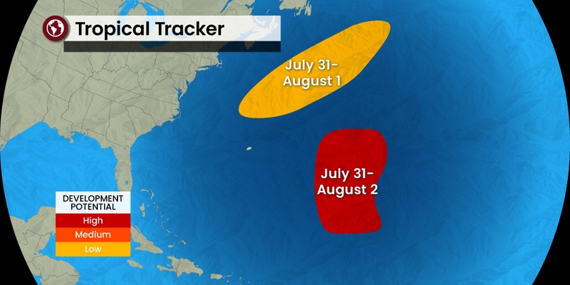
The National Hurricane Center (NHC) is carefully monitoring the Atlantic basin for two areas of potential tropical development this week. Right on time, the tropics are beginning to heat up just as July transitions into August. Here is a look at what is putting the NHC on high alert.
It has been relatively quiet across the Atlantic Ocean over the last few weeks, typical of the regularly scheduled mid-summer break from the tropical activity. After a fast start to the season with the formation of Tropical Storm Arlene at the beginning of June, Tropical Storm Bret formed less than two weeks later.
Just as the calendar flips to August, the waters are beginning to heat up and pave the way for more development in the coming days. The first area of concern is located near the East Coast of the U.S. Hurricane experts warn that this disturbance could form a tropical low that could bring impacts to the southeastern coast of the country this week.
While there are no direct impacts to land expected due to the distance from the coast, beach conditions could rapidly deteriorate in an area stretching from the Outer Banks of North Carolina and up through Massachusetts. Potential impacts include rough surf conditions and dangerous rip currents. Be sure to pay attention to any warnings if you are headed to the beach in this region this week.
This disturbance is expected to continue on a path to the northeast, pulling it away from the shore in the process. This means that Atlantic Canada should be spared any direct impacts this time around.

Another area of concern is located in the central portion of the Atlantic Ocean. This disturbance is moving to the northwest, finding warm waters and low amounts of wind shear. These are two of the most conducive ingredients needed for tropical development and intensification.
This tropical low could transition into a tropical storm by the middle of the week. However, the steering winds are expected to bring this storm to the north and away from North America and Bermuda. Unless these models change, the low is not expected to bring any major impacts to land.
Should either of these disturbances intensify into a tropical system this week, it would be the fifth named feature of the 2023 Atlantic hurricane season. The average date for the fifth named storm to take root is August 22, meaning that this season will stay on course for development that is earlier than normal. The peak of the Atlantic hurricane season happens around September 10.
The named next storm in the Atlantic basin will be called Emily.
The East Pacific is also showing signs of life this week. A tropical low is currently spinning in the East Pacific to the southwest of Mexico. This part of the Pacific has seen three named storms this year. The next name on the list for this basin is Dora.
Should this low take on tropical characteristics, it would likely happen by Wednesday. The current models show the feature moving to the west, avoiding direct impacts with land. The greatest impacts will come along the southern coastline of Mexico with the potential of rough sea conditions through the middle of the week.
The waters have been trending exceptionally warm in this part of the East Pacific. These conditions have put hurricane watchers on high alert for potential tropical development in the area just south of Mexico.
Did you find this content useful? Feel free to bookmark or to post to your timeline for reference later.

January 21, 2024

January 19, 2024

January 18, 2024