Heavy Rain, Flooding, and Chance of Severe Weather Staring Down the Southern U.S.
January 22, 2024
Posted: April 27, 2023 9:31 am


A duo of spring storms are set to move into the Northeast in the coming days with the second of the pair predicted to bring the biggest impacts to the region. Here is what you need to know heading into the weekend if you live in this corner of the U.S.
The first storm will begin to impact the Northeast by Friday. This is the same weather maker that buried parts of the Colorado Rockies under snowfall measured in feet over the middle part of the week.
This is projected to be the weaker of the two storms.
Prior to arriving in the Northeast, the system will bring rain to the Southeast on Thursday. The storm will then track into the central Appalachians, mid-Atlantic, and up through the Great Lakes before reaching the Northeast on Friday.
The southern U.S. will see a number of impacts from this multi-faceted weather system, including localized heavy rain, the chance of urban flooding, and severe storms.
This threat of severe weather will hang on in the Southeast through the end of the work week.
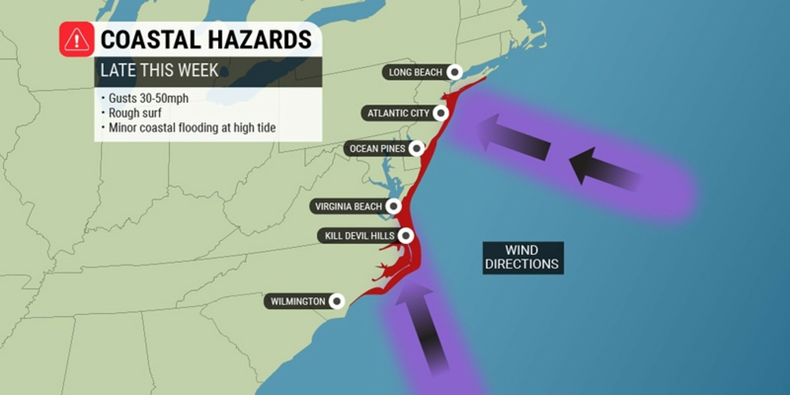
Winds will pick up along the Eastern Seaboard in an area stretching from North Carolina through New Jersey. The strongest gusts are expected Friday night into Saturday morning.
These winds will be enough to churn up the seas and create rough surf conditions.
The mid-Atlantic coastline should be prepared for winds clocking in at 15 to 25 mph with gusts up to 50 mph. This will generate a good chance of minor coast flooding and beach erosion, particularly during times of high tide.
Heading into Saturday, the Southeast and mid-Atlantic will begin to dry out as the Northeast begins to experience the height of the impacts from the second storm. Forecasters are warning that this storm has the potential to develop into a bomb cyclone late Sunday into Monday.
As residents who have been through these bomb cyclones understand, weather of this severity will undoubtedly bring a host of hazards. This system began to form early in the week over the North Pacific in the Gulf of Alaska.
The storm is now tracking through the Canadian Rockies and will stretch as far south as the southern Plains by the end of the week.
There are a number factors that will determine when and with what intensity this storm system hits the Northeast. Most notably will be the potency of the jet stream as the two elements collide.
As of the middle of the week, forecasters are predicting that at the very least, the storm will bring significant rain and strong winds across the Midwest and into the Southeast to end the weekend.
The impacts will then move into the Northeast by late Sunday and into Monday.
This is when the storm may find enough fuel to develop into a bomb cyclone. There is also a small chance of snow developing along the back edge of the storm system late Saturday. The most likely region to see this snow will be the Upper Midwest.
Forecasters are also keeping an eye out on the potential of an atmospheric river taking root in the Caribbean and up through the Atlantic into the Northeast.
Should this form, the region will be in for heavy rain as it draws up an immense amount of tropical moisture from the south. This could translate to up to 3 – 4 inches of rain over a period of just hours across the mid-Atlantic coastal regions.
Another round of strong winds will be in the cards for the Eastern Seaboard in a zone from Delaware up through Maine. Coastal flooding, beach erosion, and rough surf will be likely beginning late Sunday and lasting through Monday.
The epicenter of these inclement conditions is currently forecast for the coast of Massachusetts south of the Boston area.
The combination of gusty winds and saturated grounds could bring down trees and power lines in the coming days. In addition to those inclement conditions, a mass of cooler air will accompany the storms.
Real feel temperatures may struggle to get out of the 30s in the northern edge of the storm system.
Travel delays are likely along the northern portion of the mid-Atlantic on Sunday afternoon through Monday morning. The delays may also be an issue up into New England.
Ponding on roadways and poor visibility could be an issue for motorists across several states.
There is also the chance of airline disruptions across some of the nation’s busiest hubs. Sunday’s delays will be most likely in the Southeast and up through the Great Lakes, including airports in Atlanta, Chicago, and Detroit.
The Northeast hubs may see the delays hit later Sunday and into Monday. This includes the major hubs in New York City, Boston, Philadelphia, and Washington, D.C. You will want to check with your airline if you have travel on Sunday and Monday.
The colder overnight lows will also deliver the threat of frosts or freezes to portions of the Midwest and the Northeast. Unfortunately, forecasters are predicting that the unseasonably chilly weather will hang on through the early part of May.
The silver lining of the cooler temperatures and the wet conditions will be that the current risk of wildfire danger in the Northeast will be suppressed.
Did you find this content useful? Feel free to bookmark or to post to your timeline for reference later.

January 21, 2024

January 19, 2024

January 18, 2024