
Heavy Rain, Flooding, and Chance of Severe Weather Staring Down the Southern U.S.
January 22, 2024
Posted: July 26, 2023 12:38 pm


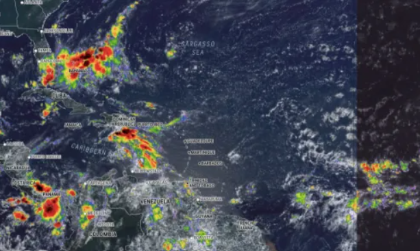
The tropics are beginning to see more action heading into the last weekend of July. The National Hurricane Center (NHC) is watching an area of potential development near the Bahamas with concerns that it may bring impacts to the Southeast in the coming days. Here is what you need to know about what is going on in the Atlantic basin.
Hurricane experts have been kept busy this week monitoring three different tropical waves moving across the Atlantic as the tropics begin to heat up. One particular disturbance could bring heavy rain to the Southeast later this week and into the weekend. This feature was positioned a few hundred miles to the northeast of the Bahamas by late Tuesday, packing rain showers and thunderstorms.
The disturbance is finding ample amounts of moisture to tap into as well as exceptionally warm ocean water measuring up to 88 degrees, two conditions needed for tropical development. In addition, a lack of mitigating wind shear in this part of the Caribbean is helping to support its growth.
The current models show that this disturbance will inch closer to Florida and northern Georgia by Friday. However, the system may also find greater amounts of wind shear as it moves closer to the U.S. mainland, leading to potential weakening. Meteorologists believe that the window for further intensification is closing, however, the system could still deliver significant impacts as it reaches the warm waters in the Gulf Stream.
The forecast is calling for an increase in heavy rain and gusty thunderstorm activity as the feature moves closer to the U.S. late Thursday and into Friday. The northern edge of the system will usher in the most significant effects, putting Georgia and the Carolinas in the bullseye.
The disturbance may reach as far as the western edge of Florida and into the inland portion of the Carolinas. Even if the feature does not intensify significantly, it will likely bring rough surf conditions and the danger of rip currents to the coastal areas of the Southeast. You will want to keep an eye on this development if your weekend plans call for a trip to the beach in this part of the U.S.
There is also the chance that the disturbance could remain to the south. This would bring greater impacts to Florida in the form of flash flooding for some of the most populated cities, including Fort Lauderdale and Miami. This rain could begin to pick up in intensity across Florida as early as Thursday.
Another tropical wave that has been under the microscope of the NHC since last week is beginning to show signs of weakening as it counters hostile conditions in the Caribbean. This wave was moving to the west near the Lesser Antilles on Tuesday, finding increasing amounts of wind shear and drier air.
However, the bathwater warm ocean temperatures in this part of the Caribbean could keep it going for a few more days. The heavy rain and thunderstorms associated with this wave could hit Central America by Friday or Saturday.
August will almost certainly bring more chances of tropical development when compared to what July brought. Meteorologists expect that there will be more tropical waves coming off the coast of Africa in the coming weeks, providing the beginning ingredients for development.
Water temperatures in this part of the Atlantic tend to trend the highest of the year during the late summer and early fall. These temperatures are more likely to support the development and growth of tropical features.
The next named tropical event in the Atlantic is set to be called Emily.
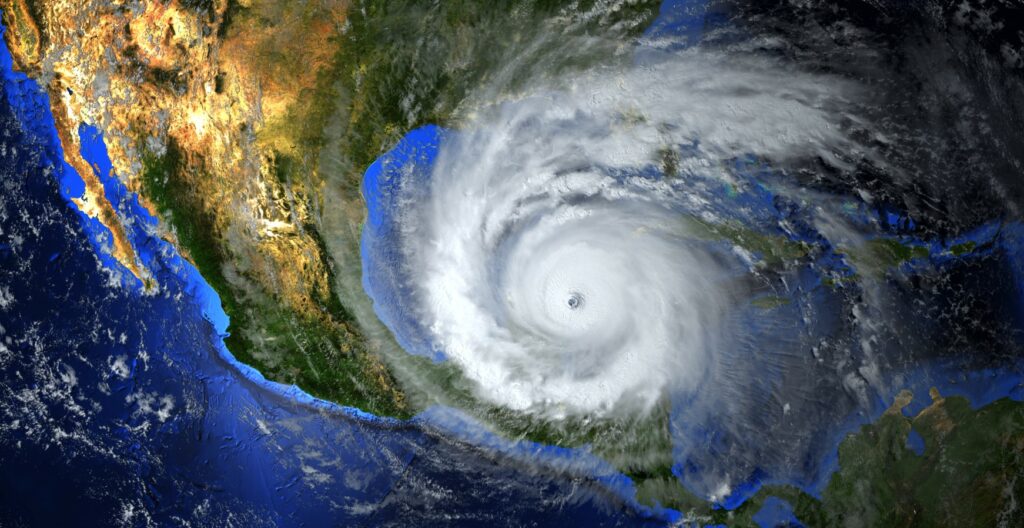
Meanwhile, on the other side of the world, Typhoon Doksuri is getting ready to brush past Taiwan after skirting past the Philippines. As of late Tuesday, the storm was the equivalent of a Category 3 hurricane, translating to the potential of severe impacts to those in its path.
The typhoon is continuing to intensify as it churns through the warm waters of the Pacific Ocean in this corner of the globe. Doksuri had strengthened into a super typhoon on Monday before losing a bit of intensity on Tuesday. Forecasters warn that Doksuri may strengthen more as it moves to the northwest in the direction of the Philippines.
Local officials in the Philippines moved to close schools and government offices across the largest and most congested island of Luzon. Evacuations have been ordered for thousands of residents in the coastal province of Cagayan. In addition, marine interests have brought in ships and suspended operation in the northern fringe of the island chain.
After skirting past the Philippines, the typhoon is forecast to move closer to southern Taiwan. It is not likely that it will make landfall in Taiwan, however, the impacts will be felt on a widespread scale on Wednesday night and into Thursday local time.
The most likely place of landfall will be in China in the eastern Guangdong or the Fujian province.
The northern Philippines will be under the gun for widespread rainfall amounts totaling up to 4 inches. Up to 12 inches may fall in northern Luzon and through the Batanes and Babuyan Islands.
Rainfall of this magnitude will create the chance of flash flooding and mudslides. The terrain of the Philippines makes it particularly susceptible to mudslides.
Taiwan is also forecast to see 4 – 8 inches of rain from Doksuri with 8 – 12 inches in the forecast for the southern tier of the country. You will find similar rainfall amounts in the impacted areas of China starting Thursday and lasting through Saturday. Moving to the western Guangdong province, rainfall amounts will total between 1 and 4 inches.
Gusty winds will also be an issue with this tropical event. Gusts of up to 140 mph are on the table across southern Taiwan and into the Batanes and Babuyan Islands through Thursday. The gusts will be strong enough to easily bring down trees and power lines, increasing the risk of widespread power outages and structural damage. Shanghai could see gusts up to 60 mph by the end of the week.
Hurricane experts monitoring the western Pacific said that the environmental conditions will be in place over the next several days for more tropical development in the Philippine Sea.
Did you find this content useful? Feel free to bookmark or to post to your timeline for reference later.

January 21, 2024

January 19, 2024

January 18, 2024
