
Heavy Rain, Flooding, and Chance of Severe Weather Staring Down the Southern U.S.
January 22, 2024
Posted: December 28, 2022 8:18 am


A much milder weather pattern will thaw out the frozen East Coast heading into the new year, bringing relief to those that have been battling the extreme cold over the last week. The Arctic air invasion sent the mercury plummeting up to 30 degrees in just a few hours right before Christmas with the bitter cold hanging around through the holiday. Things are about to change as temperatures are already on the upswing in many areas.
It was the coldest Christmas in nearly four decades up and down the East Coast. For instance, Philadelphia only hit 18 degrees for a high on Christmas Day, breaking the previous record of 21 degrees from 1989. The frigid air also infiltrated the South with cities such as Knoxville, Tennessee struggling to climb out of the low 20s for a high.
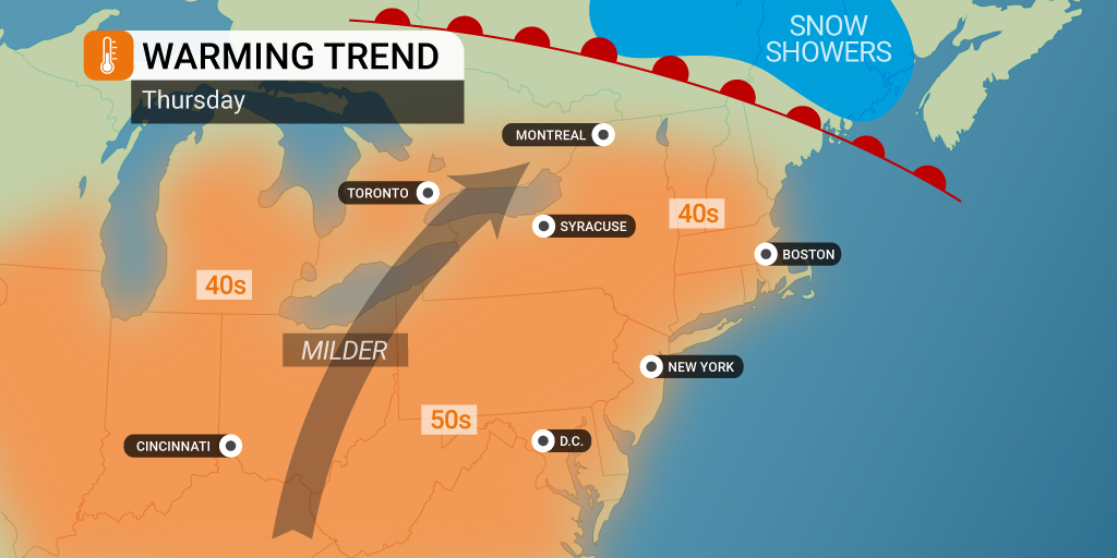
While the temperatures are slowly starting to inch up throughout the region, it has still been downright chilly throughout the eastern half of the nation. The good news is that the warming trend will pick up in the last days of the year. The warmer weather will come at the hands of a northward lift in the jet stream across the Plains states and into the Atlantic coast. This bulge will usher in warmer air from the Gulf of Mexico, sending it all the way to the Great Lakes for the last half of the week and into the weekend.
The nation’s heartland will see the warmer temperature readings by the middle of the week. For instance, cities such as Chicago, Kansas City, Oklahoma City, and St. Louis will enjoy temperatures that are up to 10 degrees above normal by Wednesday. Kansas City is forecast to hit the low 60s by Thursday, a significant change from the below zero readings just one week prior.
It also will be downright balmy to the south in Dallas with a high of about 70 degrees on tap for the middle of the week. Little Rock will hover in the upper 60s on Thursday despite clouds and rain moving through the area.
The dramatic warmup will hit the Ohio Valley by Thursday with metro areas such as Indianapolis and Pittsburgh seeing readings that hit the 50s. This will translate to a change of about 40 degrees from what the region saw on Christmas Day.
The Eastern Seaboard will finally see the temperature rebound on Friday. New York City and Boston are forecast to soar into the 50s with Washington, D.C., Baltimore, and Raleigh climbing all the way into the 60s.
All of this is good news for those headed out for New Year’s Eve festivities. It should be a great year to be outside in Times Square for the countdown to midnight. The current forecast shows temperatures around 50 degrees with a small chance of rain.
Florida will not be left out of the warmup. While tourists in the Sunshine State were understandably disappointed to be dealing with highs in the 40s throughout much of the region, the mercury will continue its upward trajectory heading into the new year. Highs will be back in the 70s and 80 throughout Florida by the weekend.
However, forecasters are cautioning that much of this warm weather will be accompanied by significant amounts of rain. It will be particularly soggy for the Southeast with the moisture likely making it as far north as the Midwest and into the Northeast as the calendar flips from 2022 to 2023.
Be sure to stay tuned to the local forecast if your plans to ring in the new year include being outside. There is also a chance that persistent fog could complicate travel. This is bad news for the thousands of travelers that are still stranded from the chaos of the Christmas winter storm.
Did you find this content useful? Feel free to bookmark or to post to your timeline for reference later.

January 21, 2024

January 19, 2024

January 18, 2024
