
Heavy Rain, Flooding, and Chance of Severe Weather Staring Down the Southern U.S.
January 22, 2024
Posted: February 21, 2023 3:34 pm


Southern Side of the Storm Will See Potential of Severe Weather
The same storm system that is hammering parts of the intermountain West to start the week is on a mission to bring the same inclement conditions across a stretch of over 2,500 miles, disrupting travel and life for much of the northern U.S. this week. Here is the latest on this developing winter storm system and how it may impact your life this week.
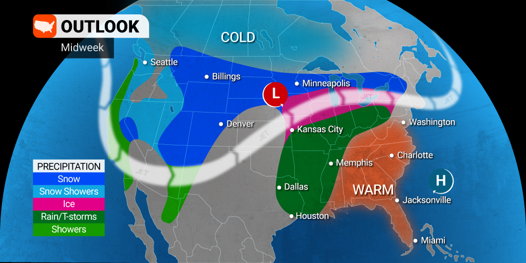
Winter storm warnings are in effect for a large swath of the Cascade Mountains in the Pacific Northwest as well as through a good portion of the Rocky Mountains and eastward. Some areas of Wyoming, Montana, South Dakota, and Minnesota are also under blizzard warnings due to the high winds that will accompany the arrival of the snow.
It is no surprise to learn that forecasters are predicting significant travel disruptions in the coming days. Snowfall in the amount of 1 – 2 feet will spread from South Dakota through central portions of Minnesota and into northern Wisconsin and Michigan. The snow in this part of the northern Plains and Upper Midwest will begin on Tuesday and hang around through Thursday.
Minneapolis will be in the primary impact zone for the worst of the snow. The Twin Cities are expected to see about 18 inches of snow this week. In fact, the February record of 13.8 inches of snow in one single event is forecast to fall.
Snow of this magnitude may shut down Minneapolis – St. Paul International Airport for a brief time. There will almost certainly be a high amount of flight cancelations and delays that create a ripple effect of air travel disruptions across the country.
The potential of blizzard conditions will trigger issues for motorists across portions of interstates 29, 35, 90, and 94. Heavy blowing and drifting snow may force the temporary closures of some stretches of highway during the worst of the storm.

In addition to the heavy snow, the region will also be under the gun for a dangerous icy mix. The widespread ice is forecast to fall near the border of Iowa and Nebraska up through the northern corner of New England.
Forecasters are predicting a zone of about 1,300 miles of ice setting up near Omaha, Nebraska and expanding through the coastal areas of New Hampshire. Cities in this impact area include Chicago, Des Moines, Milwaukee, and Detroit. The ice may accumulate in the amount of 0.25 to 0.50 of an inch, creating significant power outages and making roads impassable.
The ice will also likely lead to airline delays at major airports in Chicago and Detroit as crews are forced to take time for deicing operations. The most likely time to see these delays will be beginning Wednesday and lasting through early Thursday. Do not forget to check the status of your flight if your plans take you through any of these airports.
Moving to the east, the region will see a mix of rain, snow, and ice, depending on the temperature at the time that the moisture starts falling. The ice is not likely to be as thick across the Ohio Valley and into the lower Hudson Valley in New York. Ice in this area may only present problems on elevated surfaces. However, it is always better to be safe rather than sorry when heading out on the roads for the first time.
You can expect snowfall of about 12 – 18 inches in northern England, including across parts of Maine, Vermont, and New Hampshire. The coastal areas of Maine and upstate New York are predicted to pick up about 6 – 12 inches. While not entering record-breaking territory, the snow will be enough to cause a number of headaches.
The weather maker will bring frigid air to the north with much warmer air settling to the south. A mass of warm air will be pushed into the southeastern U.S. and beyond thanks to an area of high pressure tethered near Bermuda in the Pacific Ocean.
The warm side of the storm will see the chance of severe storms. The storms are forecast to fire up on Wednesday across portions of the Ozarks, the Ohio Valley, the central Appalachians, and the mid-Atlantic.
Rain will also be the story for a number of East Coast cities, including Washington, D.C., New York City, and Philadelphia. The moisture will also affect cities in the Midwest, including St. Louis, Cleveland, and Cincinnati.
Will this week’s snow and ice storm be the last gasp of winter? Forecasters are calling for more snow and ice throughout the Upper Midwest and the Northeast to bring February to a close. This wintry precipitation is likely to stick around intermittently in early March.
Over on the West Coast, Southern California is setting up to receive heavy rain and snow in the higher elevations starting Thursday and continuing through the early part of the weekend. Be sure to keep an eye on this forecast as it becomes more precise in the following days.
Did you find this content useful? Feel free to bookmark or to post to your timeline for reference later.

January 21, 2024

January 19, 2024

January 18, 2024
