
Heavy Rain, Flooding, and Chance of Severe Weather Staring Down the Southern U.S.
January 22, 2024
Posted: December 7, 2022 2:50 pm


Warmer Temperatures Likely to Block Snow From Interstate 95 Corridor
A large portion of the northern U.S. will be the target of widespread snow beginning Thursday. The wintry precipitation is part of the same weather maker that dumped rain and snow throughout much of the West last weekend before moving into central portions of the country this week.
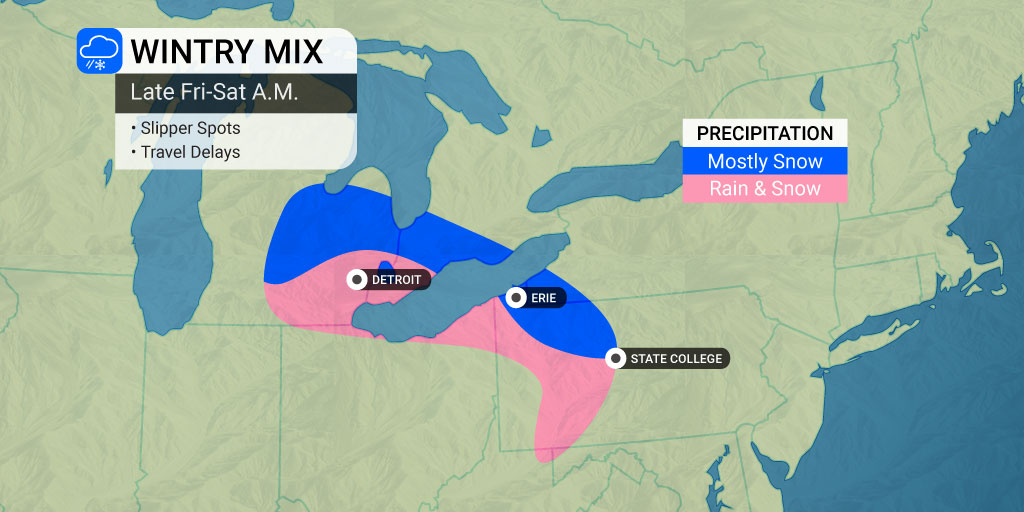
The chance of accumulating snow is in the forecast for a swath of over 1,000 miles stretching from Nebraska into New York. Major cities that should prepare for snow include Chicago and Detroit. While the system is not expected to produce heavy snowfall, accumulation of up to a few inches of snow will be enough to snarl traffic and disrupt life for some of the metropolitan areas in the path.
What cities see the bulk of the snow is largely dependent on how cold the air is as it swoops down from Canada and if an area of high pressure moving up from the Gulf of Mexico puts up a fight against the competing air mass from the north.
Forecasters are continuing to become more certain of the prediction of snow in a narrow zone stretching from western Nebraska and into southern Wisconsin. A secondary impact zone includes northern Illinois through Michigan’s lower peninsula and up through the higher terrains of Pennsylvania and New York.
Despite temperatures expected to hover slightly above the freezing mark, the snow may come down at a fast enough clip to stick to the roads for a time. As such, motorists should practice extra caution if heading out in the inclement conditions.
The worst travel conditions in the central U.S. will happen on Thursday night into early Friday. This includes the potential of hazardous travel for eastern portions of Nebraska and South Dakota through northern Iowa and the southern part of Minnesota.
The northern suburbs of Chicago will be the mostly likely area of the Windy City to see meaningful accumulation. Milwaukee and Madison, Wisconsin are also forecast to pick a few inches of snow out of this system. The Friday afternoon commute could be dicey for those in Detroit and across the Lower Peninsula such as Lansing and Grand Rapids.

A mass of dry air anchored over the Northeast could limit the moisture supply of the storm system. In addition, another storm spinning off the coast in the Atlantic Ocean may absorb some of this energy by early Saturday.
These factors will translate to a lower chance of snow throughout the Appalachians. Little to no precipitation is expected in the mid-Atlantic and southern New England coastal areas.
Warmer temperatures in the forecast for Pittsburgh, Philadelphia, New York City, and Washington, D.C. will also keep any moisture falling as rain.
The greatest odds of a wintry mix in the Northeast will be centered in a narrow area across northern and central Pennsylvania up into southern New York. Motorists will want to check road conditions before heading out on interstates 76, 79, 80, 81, 86, 88, and 90. A few inches of snow with the possibility of ice is in the forecast for this region Friday night and early Saturday.
Forecasters are also calling for a parade of winter storms through the central and eastern portions of the country in the days leading up to the holidays. This series of storms is expected to move to the northeast originating in the Mississippi Valley and traveling into the Upper Midwest, Great Lakes, and coastal Northeast.
Did you find this content useful? Feel free to bookmark or to post to your timeline for reference later.

January 21, 2024

January 19, 2024

January 18, 2024
