
Heavy Rain, Flooding, and Chance of Severe Weather Staring Down the Southern U.S.
January 22, 2024
Posted: July 14, 2023 4:13 pm


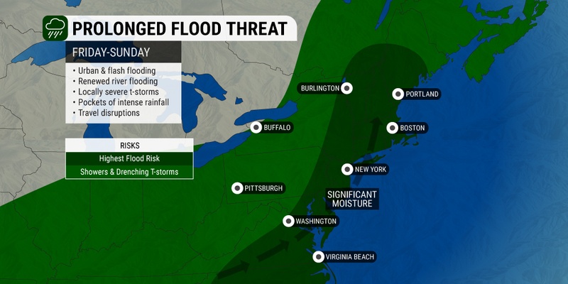
An atmospheric river is set to send a massive amount of precipitation across the Northeast in the coming days, creating the risk of life-threatening flooding. This is the second week in a row that this part of the country has been under the gun for flash flooding concerns.
The risk of flooding will increase with each new round of rain, particularly in areas that get hit by repeated downpours. Much of the ground throughout the Northeast and into New England is already saturated beyond what it can take on for additional moisture.
Atmospheric rivers are known for their fire hose effect, spreading significant amounts of moisture over a lengthy period of time. It is this same type of weather event that was the culprit behind the flooding that ravaged California earlier in the year.
The forecast is calling for local rainfall amounts of 1 – 3 inches per hour. This rain may quickly overwhelm storm drains that are already filling to capacity because of the recent parade of storms. This amount of rain may also disrupt travel throughout some of the region’s most populated cities, including New York City and Boston.
Some portions of southeastern New York state and New England could tabulate 2 – 4 inches of rain. Western and central portions of New England will see the heaviest amounts of rain with up to a foot possible over the course of the next few days.
Philadelphia, Washington, D.C., and Baltimore may also get in on the torrential rain. Because the rain will come on quickly at times, the potential of dangerous flood flooding will also be in place in these cities farther to the south. The threat of flooding could stay in place through Wednesday of next week.
An area north of New York City stretching into southern New England was already seeing some of the first episodes of stormy activity on Friday. Saturday is set to bring a brief bit of relief to the storm weary region with some drying out expected.
This will be the best day of the weekend to get outside. However, small amounts of moisture circulating in the atmosphere could still create stray rain showers and thunderstorms to start the weekend.
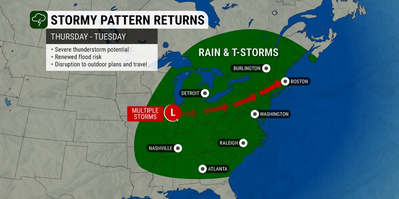
A new storm system setting up across the Midwest on Saturday will move to the northeast on Sunday, bringing another shot of heavy rain to the area to close out the weekend. The energy from this system will bring in tropical moisture from the Atlantic Ocean to create yet another deluge of rain.
This atmospheric river is set to unfold in a zone stretching from eastern Pennsylvania, into New Jersey and southern New York, and up through New England.
Sunday’s disturbance is forecast to be larger and stronger than the system that swept through the area on Friday. This intensity will translate to the chance of some overflow of the region’s major rivers, including the Merrimack, Charles, and Connecticut.
The odds of urban flash flooding and river flooding will be the highest in the part of the Northeast and New England that saw the bulk of the activity last Sunday and Monday. Some parts of upstate New York, Vermont, and western Massachusetts saw a widespread 5 – 10 inches of rain during last week’s event.
Local officials are continuing to warn motorists to exercise caution when driving during this type of rain. You should never attempt to traverse a flooded road. Those heading out for outdoor activities such as hiking should also be aware of the risk of small stream flooding that could happen instantly.
More rain is in the forecast through at least Wednesday before the storm finally pushes out to sea. However, the weather maker is likely to pull in more moisture when it reaches the coastal areas, meaning that it will not exit without a bang.
The long-range forecast is calling for a brief break from the moisture on Thursday and Friday of next week before the weekend ushers in yet another round of precipitation for the Northeast and beyond.
Did you find this content useful? Feel free to bookmark or to post to your timeline for reference later.

January 21, 2024

January 19, 2024

January 18, 2024
