
Heavy Rain, Flooding, and Chance of Severe Weather Staring Down the Southern U.S.
January 22, 2024
Posted: July 12, 2023 1:25 pm


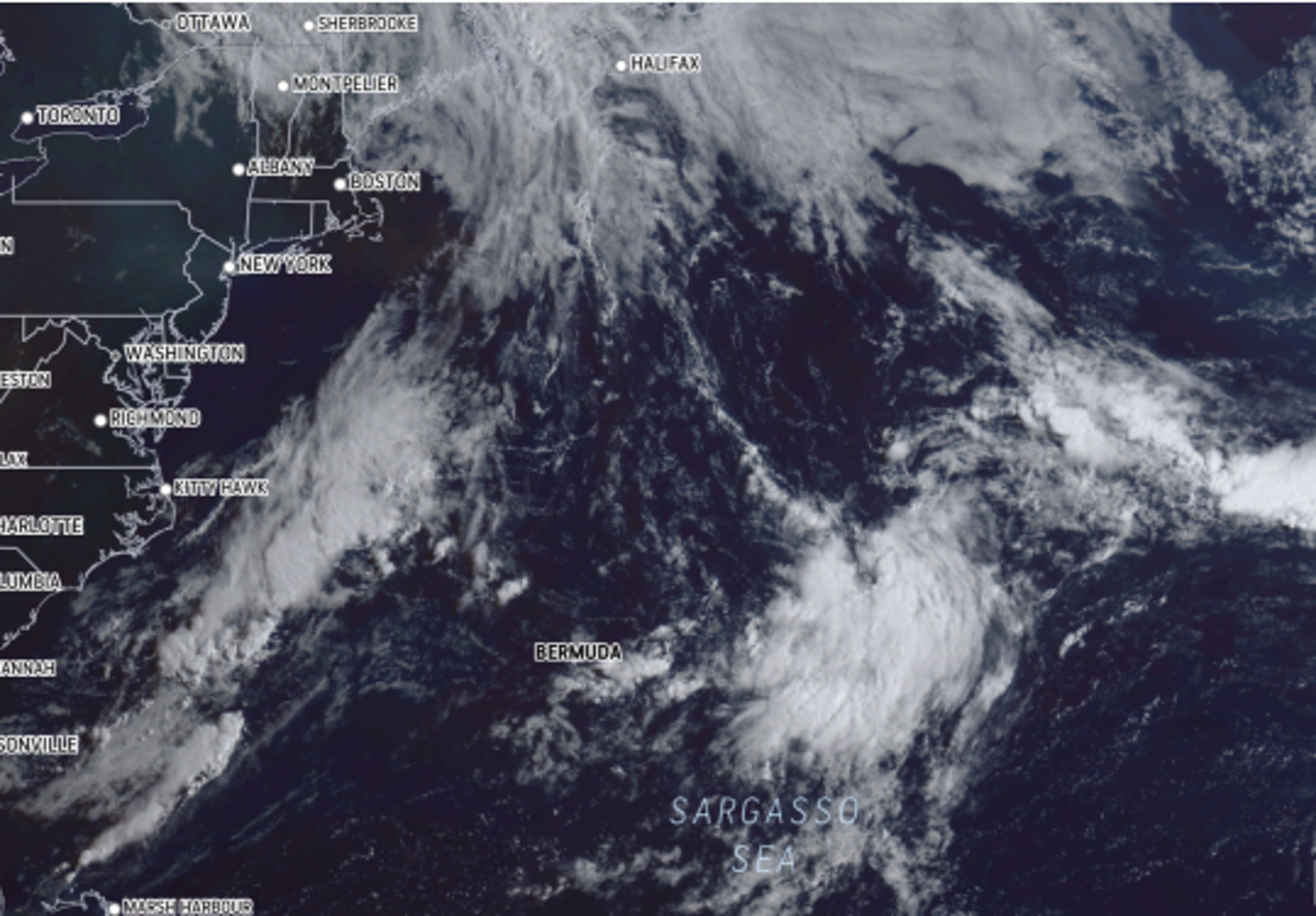
It has been awfully quiet in the Atlantic basin lately. There have been no named features in this part of the ocean since late June, however, forecasters are warning that signs of tropical development are picking up.
The Atlantic basin has been calm and tranquil thanks to a large area of Saharan dust that has blown across the region in recent weeks. Originating in Africa’s Saharan Desert, this cloud of dust works to mitigate the opportunities for tropical systems to develop.
The lull in activity may change in the coming days as a disturbance circulating in the central Atlantic Ocean has the potential of taking on tropical characteristics later this week.
The last named storm to move across the Atlantic basin was Tropical Storm Cindy. This feature did not bring any significant impacts to the U.S. or any islands in the Caribbean.
The only impacts felt by Cindy were an increase in heavy rain from the outer bands across some of the Leeward Islands and into Bermuda. What was left of Cindy then went on to bring rain to Atlantic Canada as it moved to the north.
The latest disturbance that has raised eyebrows is still positioned far from any major land masses. The area of storms and showers is moving several hundred miles to the east and northeast of the Bermuda islands on Tuesday morning. While there is a good amount of moisture associated with this system, the feature is not showing any signs of organization or formal spin.
The weather maker is set to move over an area of warm ocean waters that will encourage its further development. In addition, an absence of wind shear will help to support its strengthening. The greatest threat of development will happen on Thursday or Friday. The feature is likely to create rough surf conditions throughout the Azores this weekend.
Should any formal tropical development occur, it will likely fade away quickly when the system moves into cooler ocean waters over the weekend. The next name up on the 2023 list of Atlantic tropical system names is Don.
The waters look quiet throughout the rest of the Atlantic basin. The continuing presence of the Saharan dust cloud will work to further mitigate the chances of new development heading into next week. But hurricane experts are warning that activity could pick up in the Atlantic by the end of July.
Looking ahead to the rest of the Atlantic hurricane season, the National Hurricane Center (NHC) is monitoring the marine heat wave that has set up off of the coast of Florida. Sea surface temperatures are registering in the 90s in some parts of the water off the coast of South Florida.
Not only will these unusually warm water temperatures negatively impact the ecosystem in this part of the Atlantic but it could also set the stage for tropical weather growth. While water temperatures typically surge this time of the year, the readings are higher than normal by this point in the summer.
A marker located near Bob Allen keys, Florida hit a reading of 96.3 degrees earlier in the week. These temperatures generally hover in the upper 80s in July. Moving closer to Miami, the water temperatures are hitting the 90-degree mark with regularity.
These abnormally warm waters work as fuel for tropical development as the systems approach land. What is most worrisome to climate experts is that these marine heat waves tend to hang on for months or even years, relying on a significant change in the weather pattern to lower the readings. This means that these warmer than average water temperatures are likely to stick around throughout the rest of the 2023 hurricane season.
The presence of Saharan dust combined with a higher than average amount of wind shear has so far worked to inhibit the development of tropical systems in the Atlantic this year. However, once these inhibiting factors ease, the marine heat wave could spur the development of multiple named storms as the season kicks into high gear.
The latest research from the National Oceanic and Atmospheric Administration (NOAA) indicates that marine heat waves are increasing around the world. In addition to the Florida marine heat wave, a large mass of warm water is currently circulating near Peru off the coast of South America.
Did you find this content useful? Feel free to bookmark or to post to your timeline for reference later.

January 21, 2024

January 19, 2024

January 18, 2024
