
Heavy Rain, Flooding, and Chance of Severe Weather Staring Down the Southern U.S.
January 22, 2024
Posted: May 23, 2023 3:00 pm


The official kickoff to the Atlantic hurricane season is right around the corner with a start date of June 1. And right on time, forecasters are keeping a close eye on the potential of a homegrown tropical event that could pop up along the southeast coast of the U.S. in the coming days.
Here is the latest on this area of concern.
The development of this tropical feature could put a damper on Memorial Day weekend plans. Beachgoers planning for fun along the southeastern Atlantic coast may spend the holiday weekend dealing with heavy rain and rough surf conditions.
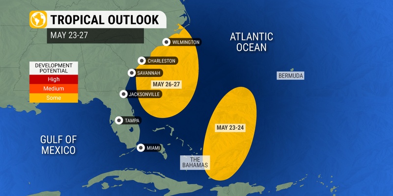
Forecasters will be monitoring two separate areas of potential development this week and heading into the weekend. Warm waters off the southeast coast of the U.S. are providing the groundwork for tropical development to fire up.
This warm water will make it easier for a front to move in and harness the conditions to trigger what experts refer to as a homegrown storm.
The first area of concern is located just east of the Bahamas. This vast area of tropical moisture has already been creating heavy rain and flooding for parts of Bermuda and Puerto Rico. Hurricane experts warn that this feature could take on a defined area of circulation in the coming days.
However, this feature is likely to dissipate as it moves to the north and meets with drier pockets of air and an increase in the amount of wind shear. Both of these factors tend to greatly inhibit tropical development.
In addition, the absence of significant low pressure located at the middle levels of the atmosphere will likely stifle further development. While there is plentiful low pressure located at the surface of the water, tropical systems need this development to move vertically in order to take root and intensify.
Should the feature find the fuel it needs, its projected path will take it well east of the U.S. mainland. This will limit its impact to Americans regardless of how it develops.

The second zone of possible development is more concerning to hurricane forecasters. This zone is developing closer to the Southeast, raising the chance of impacts to the U.S by the weekend. Some models are forecasting that a group of storms may try to come together in the Gulf Stream over the next few days.
This stream is a thin zone of atypically warm ocean water temperatures. The current temperature in the Gulf Stream is coming in at about 80 degrees, above the minimum mark of approximately 77 degrees needed to support tropical development.
The biggest question mark for this system is if it will have enough time to feed on these warm ocean waters to strengthen before it tracks inland and weakens.
The current forecast is skeptical that the system will have sufficient time to develop enough to cause significant concerns. However, this is not an exact science and conditions can change quickly.
Should a tropical storm form, it would take on the name Arlene. The second name on the list of names for the 2023 Atlantic hurricane season is Bret.
Even if this homegrown system does not take on official tropical characteristics, it is still expected to bring inclement conditions to the southeast coastline this weekend just as the Memorial Day holiday gets going.
A dip in the stream is not expected to lift this week, bringing down unseasonably cool temperature readings for the Southeast.
Storms will fire up early in the week for parts of Georgia, South Carolina, and into the northeastern corner of Florida. Tuesday afternoon and evening could be potentially disruptive with the forecast of heavy rain and strong winds.
Calmer conditions will return to the interior Southeast by Wednesday while the stormy activity remains along the coastal areas. The worst of this week’s storms will hit the coastal areas from central Florida heading up into the Carolinas by the end of the week and into the weekend. Times of high tide could also bring minor coastal flooding and beach erosion.
Forecasters warn that if the system approaches the coast, beachgoers may be beholden to severe thunderstorms, moderate coastal flooding, damaging winds, isolated waterspouts or even a tornado.
You will want to keep a close eye on this developing forecast if your three-day weekend plans have you visiting this stretch of coastline.
It is also possible that this heavy rain and gusty winds expand into the mid-Atlantic over the weekend. Pockets of subtropical moisture may also move as far west as the central Appalachians.
While it is still too early to count on with certainty, the dry air and pleasant conditions may hold on through the Northeast and New England over the holiday.
Did you find this content useful? Feel free to bookmark or to post to your timeline for reference later.

January 21, 2024

January 19, 2024

January 18, 2024
