Heavy Rain, Flooding, and Chance of Severe Weather Staring Down the Southern U.S.
January 22, 2024
Posted: August 30, 2023 9:37 am


Hurricane Idalia will not be done after it cruises through Florida. The storm is expected to continue on its path to the northeast, bringing a host of impacts to a large portion of the southeastern U.S. Forecasters also warn that Idalia could pass through the Southeast two separate times. Here is the latest on what the experts predict will happen with Idalia after it makes landfall in Florida.
While there is no doubt that the west coast of Florida will likely see the worst of the impacts, that does not mean that other areas will be spared. Despite losing wind intensity as it interacts with the land, Idalia will still deliver a blow to many communities on the other side of Florida and as far north as Virginia.
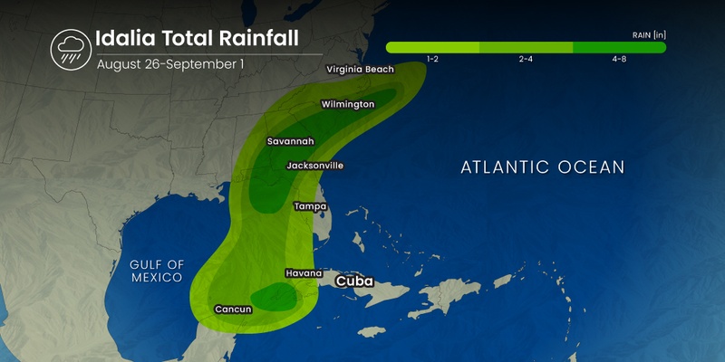
Tropical downpours are in the forecast for portions of Georgia and the Carolinas beginning on Wednesday. This massive amount of moisture will create the risk of flash flooding throughout much of the Southeast as it merges with a stationary frontal boundary currently parked over the region. This preexisting frontal boundary has already been responsible for dumping a significant amount of rain late Tuesday. The addition of new moisture into the area will only serve to heighten the risk of flooding.
How much rain can you expect?
Forecasters are warning that rainfall amounts of 4 to 8 inches will fall in eastern Georgia and up into the Carolinas through the end of the week. It could be a soggy start to the Labor Day weekend for this part of the country. Cities under the gun for significant amounts of moisture include Raleigh and Myrtle Beach.
The good news for the higher terrains of the Appalachians is that the heavy rain is expected to fall to the south of this mountain range, mitigating the risk of mudslides.
Heavy rain will not be the only meaningful impact with Idalia’s approach into the Southeast. The storm is also forecast to bring in strong winds that create some degree of damage as far as 100 miles inland across the Southeast. Peak wind gusts of up to 60 mph are in the forecast for the eastern portion of the Carolinas.
The central coastal areas of South Carolina and coastal Georgia are bracing for the strongest gusts, potentially hitting as high as 80 to 100 mph. This impact zone includes the historic city of Savannah, Georgia.
Now is the time to secure outdoor furniture, barbecue grills, and other loose items that could become projectiles with high winds. Conditions are expected to worsen throughout the day Wednesday, making it important to cross these tasks off of your list as early as possible.

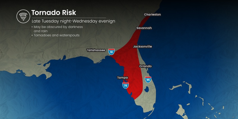
As is typical with these tropical weather events, tornadoes and waterspouts are most likely to spin up in an area to the north and the east of the center of circulation. Tornadoes are particularly dangerous during times of tropical weather because the funnel clouds can be hidden by the heavy rainfall. This makes it even more important to enable all of your weather alerts on your smartphone.
Cities that will see a high risk of tornadoes on Wednesday include Jacksonville, Savannah, Charleston, and Wilmington.
There is also an outside possibility that Idalia may make two passes at the Southeast. The latest forecast models show that Idalia could meander near the coastline once it cuts a path inland. The forecast of weak steering breezes positioned off the coast of the Southeast could translate to Idalia not moving off into the open sea at a fast clip.
Should Idalia linger off the coast of the Southeast, there is a chance that it could come back around and threaten the U.S. later in the weekend. The east coast of Florida would be the most likely place for Idalia to re-emerge.
Even if Idalia does not make a second landfall in the U.S., the coastal areas from Florida and up through Virginia are going to be dealing with rough surf conditions and rip currents throughout much of the holiday weekend.
Did you find this content useful? Feel free to bookmark or to post to your timeline for reference later.

January 21, 2024

January 19, 2024

January 18, 2024