
Heavy Rain, Flooding, and Chance of Severe Weather Staring Down the Southern U.S.
January 22, 2024
Posted: July 5, 2023 11:11 am


Storms will continue to impact a large portion of the central U.S. this week, bringing a number of impacts to the Rockies, the Midwest, and the Plains states. Is your community in the line of fire? Here is what you need to know about the developing storm systems.
July is off to a stormy start for the nation’s heartland. The start of the week brought widespread reports of damaging hail and winds throughout Wyoming, South Dakota, Minnesota, and Iowa. The Fourth of July saw this trend continue with more storms rumbling around and ruining the outdoor festivities for several areas.
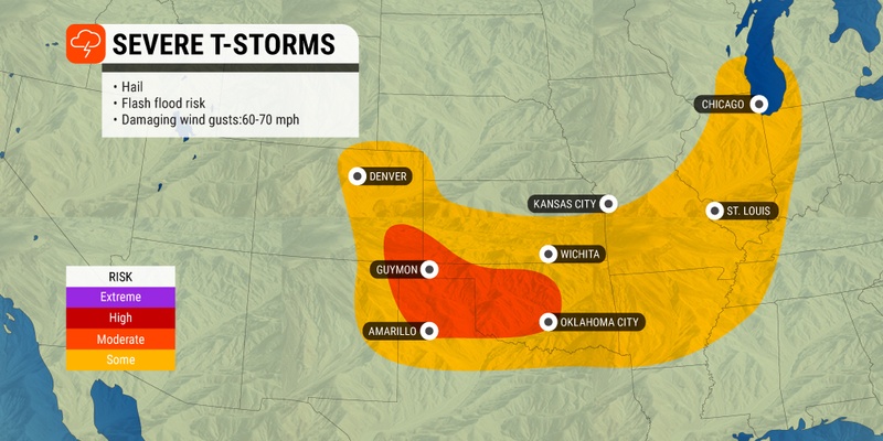
The same area that was in the impact zone for Tuesday’s storms will once again see the threat of severe weather on Wednesday and Thursday. For instance, the city of Denver could see storms ignite for three straight days.
The line of storms is forecast to move to the southeast on Wednesday, bringing more cities and towns into the fold. Wednesday’s risk of storms will stretch from the northeastern corner of New Mexico up into eastern Colorado and across to Kentucky, Indiana, and beyond. The major threat of these storms will be strong wind gusts measuring up to 70 mph.
Road trippers headed home from holiday festivities may encounter slow conditions along portions of interstates 25, 35, 40, 44, 55, and 70 due to reduced visibility and ponding on the roadways. Major cities such as Oklahoma City, Wichita, Kansas City, St. Louis, and Chicago may see the impacts from these storm cells on Wednesday afternoon and evening.

The greatest threat of storms will shift to the north on Tuesday, ushering in the chance of severe weather for the northern and central Plains. The most likely areas to see storms develop on Thursday afternoon include eastern Wyoming, the southwestern corner of South Dakota, western Nebraska, Kansas, Oklahoma, and the northern tier of Kansas.
Like Wednesday’s activity, these storms could produce small hail, damaging winds, and isolated tornadoes through the evening and overnight hours on Thursday. Forecasters are warning that nocturnal tornadoes could be a possibility. Be sure to enable your weather alerts if you live in this general area.
While the severe weather will certainly present some challenges, the rain is good news for the parts of Kansas and Nebraska that are still dealing with drought conditions. According to the latest report from the U.S. Drought Monitor, this part of the country is experiencing some of the most worrisome drought conditions in the country.
For example, nearly 75% of the state of Nebraska is under a designation of at least a moderate drought. More concerning is the report that more than 13% of the state is under an exceptional drought categorization.
Unfortunately, heavy rain paired with dry soil increases the risk of flash flooding. This is because too much rain over a short period of time is difficult for dry soil to absorb.
Yet another storm is set to move through the Plains by the end of the week. Friday’s stormy activity is likely to hit areas of eastern Colorado, Kansas, Missouri, and Oklahoma. Stay tuned to the forecast as meteorologists fine tune the potential impact zone.
The ongoing storms are also forecast to remain in the central Plains through the weekend. While there will be some periods of dry and pleasant weather, you will want to keep an eye on the hourly forecast if you have outdoor plans over the next several days.
Did you find this content useful? Feel free to bookmark or to post to your timeline for reference later.

January 21, 2024

January 19, 2024

January 18, 2024
