
Heavy Rain, Flooding, and Chance of Severe Weather Staring Down the Southern U.S.
January 22, 2024
Posted: September 5, 2023 9:45 am


Experts at the National Hurricane Center (NHC) are warning that a new named storm is on the horizon, set to take on the name Lee. The storm is likely to impact parts of the northeastern Caribbean in the coming days. Here is the latest on this potential new development as the 2023 Atlantic hurricane season heads toward its statistical peak.
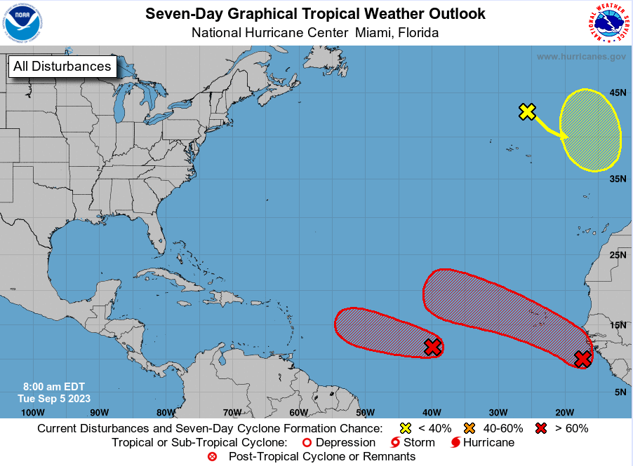
The tropical wave is currently moving through the central portion of the Atlantic basin. The NHC has designated this feature as Invest 95L. The feature is forecast to travel into favorable environmental conditions this week, supporting its further growth and intensification. It may even find the conditions needed to develop into a hurricane.
As of mid-day Monday, the disturbance was located several hundred miles to the southwest of the Cabo Verde Islands. The feature is moving to the west into a part of the basin that will encourage further organization. These supportive factors include exceptionally warm ocean water temperatures, an abundance of moisture, and a lack of vertical wind shear.
All three of these conditions are forecast to remain in place over the next week, meaning that any disturbance that wanders into this part of the Atlantic will have a good chance of surviving and thriving. The only factor currently in place that could inhibit this growth is the presence of sinking air. This element could work to mitigate the formation of clouds, slowing down tropical development.
Forecasters believe that the sinking air may slow down the development of this feature but it may not be enough to prevent it from taking on tropical characteristics.
The tropical wave will continue on its westward journey through the Atlantic, eventually tracking into the eastern Caribbean. At this point, the storm is predicted to move to the north of the northern Leeward Islands and Puerto Rico. The timing of the track has it in this part of the Caribbean by the end of the week and into the weekend.
Other areas under the gun for potential impacts by the weekend include Antigua, Barbuda, Anguilla, and the U.S. Virgin Islands. While none of these island groups are expected to take a direct hit at this time, you cannot rule out heavy rain and strong winds from the outer bands of the weather maker.
The forecast for early next week indicates that steering winds in this part of the Atlantic will send the system to the northeast of the Bahamas as it slows down to a crawl. It will then find a part of the Atlantic that has seen a considerable amount of tropical weather activity over the last few weeks. Although the water has been cooled due to the churning of the seas as of late, the temperatures are forecast to inch back up by the time the storm arrives to feed on this heat.
It is too early to tell if this storm will impact the U.S. and Atlantic Canada. The steering winds will largely dictate where the feature drifts over the next week. While there is a chance that the U.S. will dodge this storm completely, other models indicate that it could hit anywhere along the East Coast or into Atlantic Canada. Any potential landfall would likely happen between the dates of September 13 and 16.
This storm is right on time to impact the Caribbean at the peak of the Atlantic hurricane season, considered to fall on September 10. Meteorologists will stay on top of this developing situation in the coming days. Anyone on the East Coast of the U.S. or the Caribbean should be prepared for potential impacts.
Did you find this content useful? Feel free to bookmark or to post to your timeline for reference later.

January 21, 2024

January 19, 2024

January 18, 2024
