
Heavy Rain, Flooding, and Chance of Severe Weather Staring Down the Southern U.S.
January 22, 2024
Posted: June 12, 2023 3:00 pm


A multi-day severe weather event is setting up across the East Coast and the South starting Monday afternoon. Here is what you need to know about this developing weather situation.
The East Coast will be first up to see the storm development as the system that triggered nasty conditions in the central U.S. over the weekend is pushing eastward to start the work week.
While widespread significant disruptions are not in the cards, the storms could put a damper on outdoor activities stretching from New Jersey down into the Gulf Coast region.
The primary hazards of this weather maker will be strong winds and frequent strikes of lightning. Small hail and isolated tornadoes can also spring up in some of the most potent storm cells.
Cities under the gun for the late Monday storms include Philadelphia, Washington, D.C., Charlotte, Charleston, Atlanta, and Mobile.
The storms will first fire up during the afternoon hours. You can expect the activity to begin to break up later in the night as drier air moves into the area.
The moisture will not be enough to mitigate the drought conditions that have begun to set up across parts of Pennsylvania, Delaware, Virginia, and Maryland. It was a particularly dry spring for this part of the Northeast and the mid-Atlantic.
While Monday’s storms will not pack a lot of moisture, more rain is in the forecast for later in the week.

Also this week, more storms are on tap for the central and southern portions of the country. Several rounds of storms are predicted this week as competing air masses collide over the nation’s heartland.
Warm air and plenty of moisture will set the stage for this development over the Plains states and into the Mississippi Valley in the coming days as atmospheric energy builds.
This week’s storms will follow a rocky Sunday across the Plains and the Southeast. According to the National Weather Service (NWS) Storm Prediction Center (SPC), almost 300 reports of damaging winds and large hail were recorded in an area from Colorado down into the Carolinas.
Hail as large as baseballs pummeled parts of Denton County, Texas on Sunday. This heavily populated area is located in the northwest corner of the Dallas-Fort Worth metroplex.
The storms migrated to the east, cutting power in places in Alabama and Tennessee. Approximately 10,000 customers were still in the dark on Monday morning thanks to the violent storms the night before.
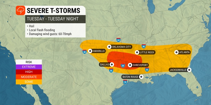
Storms in this part of the U.S. will continue to cause problems heading into the new week. Monday’s biggest threats will pop up in the Plains states, stretching from eastern Colorado, southwestern Kansas, the Oklahoma Panhandle, northern Texas, and much of the Gulf Coast and Southeast.
Once again, the Dallas area will be ground zero for the worst of the storms.
These storms will bring the usual impacts of torrential rain, hail, strong winds, and isolated tornadoes.
The rain will be welcome in western Oklahoma and Kansas, an area of the heartland grappling with the worst drought conditions in the nation.
According to the U.S. Drought Monitor, 91% of Kansas is under a designation of abnormal dryness to an exceptional drought. The same situation is developing across the panhandle of Oklahoma with most of this region under a classification of a severe drought.
The greatest chance of severe weather will move to the east by the middle of the week. For instance, Wednesday’s threat will center on the Southeast, bringing cities such as Atlanta and Montgomery, Alabama into the fold.
The southern U.S. will likely be the part of the country that will experience the most severe weather impacts as the work week comes to a close. Be sure to stay on top of the developing forecast if you live in this area.
Did you find this content useful? Feel free to bookmark or to post to your timeline for reference later.

January 21, 2024

January 19, 2024

January 18, 2024
