
Heavy Rain, Flooding, and Chance of Severe Weather Staring Down the Southern U.S.
January 22, 2024
Posted: May 10, 2023 9:29 am


The severe weather pattern that has been impacting the central portion of the U.S. over the last week is forecast to continue in the coming days with Texas taking the brunt of the stormy conditions.
Here is what you need to know about these risks and how they may hit at a particularly inopportune time near the Texas border with Mexico.
Local officials in Texas are warning that the severe weather may strike just as border restrictions are eased and more migrants cross the border into the country. The severe weather will create a significant chance of flooding throughout the region by the weekend.
Tuesday brought a number of severe weather threats to a large portion of the nation, stretching from the Gulf Coast, up through the central Plains states, and across into coastal Carolina. While the Plains states will remain under the gun for severe weather on Wednesday, the impacts are forecast to be less widespread.
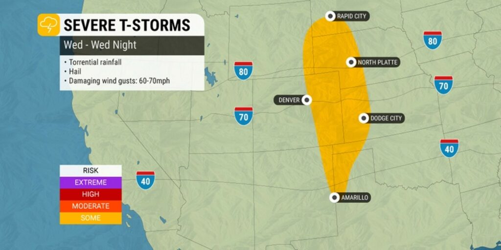
The next risk is a slow-moving storm system that is coming together over the Front Range of the Rocky Mountains. This weather maker will affect the central U.S. and into the southern Plains on Wednesday and Thursday.
Cities that may see storms pop up as this system moves through includes Denver, Amarillo, and Rapid City. Wind gusts of up to 60 mph are a possibility with this particular storm system.
The line of storms is expected to move eastward on Thursday, bringing cities such as Kansas City, Omaha, Wichita, Sioux Falls, and Oklahoma City into the mix. Thursday could mark the third straight day of dangerous storms for some communities in the nation’s heartland.
You will find a number of hazards associated with these mid-week storms. Risks include large hail, damaging winds, and widespread tornado activity.
This is a good time to check your weather alerts to make sure that everything is enabled on your smartphone as these storms could come on suddenly and with little warning.
The storms are expected to drop meaningful moisture across a part of the region that could use the rain. However, forecasters warn that too much rain over a short period of time could trigger flash flooding as the dry ground is not able to absorb moisture of this magnitude.
You will want to exercise caution if you are traveling across the major highways in the central U.S. over the next few days.
The threat of flooding will lessen in the northern and central Plains by the end of the week. But the risks will persist in locations to the south. Texas will be in the bullseye for torrential rain ending the week and heading into the weekend.
The heaviest rain will likely fall in the central portions of the Lone Star State in what is known as Hill Country.
Rainfall amounts of 8 – 12 inches are in the forecast for south-central Texas, including the area just to the west of San Antonio and Austin. The flooding could pose problems as state officials prepare for a surge of migrants in the coming days.
The Trump-era Title 42 restrictions are set to expire on May 11, making it easier for migrants to cross the border.
The heavy rainfall and threat of flooding will extend down into the state’s border with Mexico, potentially creating a severe humanitarian problem as vulnerable populations enter the U.S. with no housing or other safety nets.
The highest potential of flash flooding near the Rio Grande River is forecast for the busy ports of entry into the U.S. in Eagle Pass and Laredo. The timing of the worst of the rain and potential flooding will be late Friday into Saturday.
Did you find this content useful? Feel free to bookmark or to post to your timeline for reference later.

January 21, 2024

January 19, 2024

January 18, 2024
