
Heavy Rain, Flooding, and Chance of Severe Weather Staring Down the Southern U.S.
January 22, 2024
Posted: May 31, 2023 3:00 pm


The official start to the 2023 Atlantic hurricane season kicks off on June 1. And just in time, the tropics are beginning to heat up. Hurricane watchers are keeping an eye on an area of potential development across the Gulf of Mexico in the coming days.
Forecasters are warning that parts of Florida will feel the impacts of this weather maker even if it does not take on tropical characteristics.
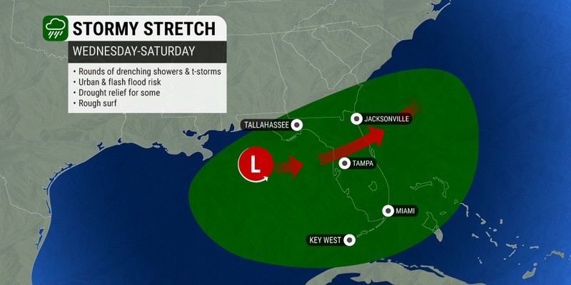
The area of thunderstorms is predicted to fire up in the next week as it moves over the Sunshine State. Should the storm intensify into a named system, it will go by the name of Arlene.
The latest satellite images indicate an area of thunderstorms coming together over the central Gulf of Mexico. The current forecast predicts that the system will not organize until Thursday at the earliest.
The sea surface temperatures across the central and eastern Gulf are coming in between the mid 70s and the low 80s. These readings need to be in the upper 70s in order to support tropical development.
This part of the Gulf of Mexico was previously earmarked as a place of potential tropical development to start the month of June. The warm ocean waters circulating in this part of the basin is the primary reason for this concern.
In order to take on the designation of a tropical depression, the area of low pressure needs to feature thunderstorms moving around the center of the low. The feature will be upgraded to a tropical storm if wind speeds within this area hit at least 39 mph.

The steering breezes that are present in this part of the Gulf will send the zone of development moving to the east with Florida in its sights. The Gulf Coast of the state will see heavy rain and winds prior to the storm’s arrival.
This means that the stormy conditions could fire up as early as Thursday for western portions of Florida. At this point, forecasters are not certain about how long the wet and raw weather will linger across the peninsula.
This is the time of the year that typically sees storm development in the afternoon hours. However, it has been an exceptionally dry start to the rainy season for all of Florida with the exception of the southeastern corner of the peninsula.
The driest part of the state is the west-central portion. For instance, Tampa has only measured a bit over 50% of the historical average of rain for the year thus far.
How much rain can Florida expect out of this weather maker? The current forecast is calling for 1 – 2 inches of rain across the northern half of the state beginning Wednesday and lasting through Saturday. The southern tier will likely pick up a general 2 – 4 inches over this same period.
However, a shift in the storm’s track could altar these measurements. For example, the Florida Panhandle could see greater impacts if the system takes a more northerly journey across the Gulf.
In addition, a strengthening of this system into a tropical depression or storm would trigger significantly higher amounts of moisture.
Water temperatures are also trending warmer across the western Atlantic Ocean east of Florida. However, increasing winds in this part of the Atlantic will likely limit tropical development in the coming days.
Higher amounts of wind shear spinning between the Bahamas and Bermuda is already working to mitigate thunderstorm development in this region.
Conversely, the wind shear in the Gulf of Mexico has not yet been strong enough to prevent tropical development. This is why the National Hurricane Center (NHC) has raised the alarm about potential development in this corner of the basin.
This is not the first time this year that the NHC has been monitoring the Atlantic basin. Just last weekend, a system picked up steam off the coast of the Carolinas as it approached the coastal areas of the Southeast.
The system came onshore and lost intensity before it was able to take on enough tropical characteristics to earn it the designation of a depression or tropical storm. That said, the weather maker was potent enough to wash out the Memorial Day weekend festivities for the Carolinas and into Virginia.
Passengers on a Carnival Cruise ship also were dealing with rough seas over the weekend. The Carnival Sunshine was inundated with water, frightening passengers and delaying the travel from the Bahamas to South Carolina.
Did you find this content useful? Feel free to bookmark or to post to your timeline for reference later.

January 21, 2024

January 19, 2024

January 18, 2024
